Olga and Bob's Most Excellent Adventure

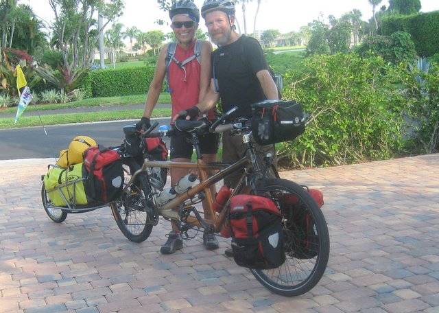
Olga (our trusty tandem bike) and BOB (our trailer) will take us from Maine to Florida along the Adventure Cycling Associations' East Coast Route. The trip begins on August 30th and will end sometime in early November. We'll be blogging along the route so check back often for the latest posting. If you want to read this in chronological order, start from the bottom and work your way up. Otherwise, it may not make sense. See you on the trail!

Name: Matt and Mary Ellen

Saturday, January 27, 2007

The End of the Journey

 Posted by Picasa

Wednesday, November 15, 2006

A New Beginning

Generally speaking, a tandem bike doesn’t require any more maintenance than a bicycle built for one. Cables are longer, there are more chains to fuss with, and brake pads do wear more quickly. Other than that, the differences begin to blur. Oh yes, there’s one more thing...the rear tire wears out faster on a tandem. Knowledgeable bike folks recommend that the tires be rotated (front to back) at about 1000 miles and be replaced at the next “service interval”. Matt had commented more than once that we should probably rotate the tires, but things had been going so well for us that he just kept putting it off. Life teaches you that it pays to do preventive maintenance with any mechanical device as sooner or later you are going to have to deal with it. So it should come as no surprise that we awoke to find that our rear tire had gone flat once again.

Common decency and decorum prevent us from repeating what was said at the time. We had one new tube and one that had been patched from the previous day. It seemed peculiar that we rode for a full day with not even a hint of a leak, but there we were, confronted with the brutal reality of a tire flatter than a pancake. Not knowing what was wrong, it was time to throw in the towel and get a new tire. The problem of course was that the closest bike shop was about 8 miles down the road in Palm Beach. Matt put air back into the tire again and it seemed to hold. Maybe he had forgotten to tighten the valve and the air leaked out overnight. It’s amazing what you can talk yourself into when you engage in wishful thinking. Since our “pump and ride” method worked so well a few days before, we decided to give it a go. If we could cycle 3 or 4 miles, stop and pump it up, we’d be at the bike shop without the hassle of changing the tire again. It certainly was worth a try.

We rode over the causeway into Riviera Beach and made it 5 miles before we needed to refill. And that was a good thing because while Riviera Beach is located next to one of the swankiest communities in the US, it is not a place you want to be hanging around, even in the morning. By now Matt had gotten the pump routine down, putting in 150 strokes to get the tire back to normal. Feeling pretty sure that we pushed on and entered West Palm Beach. There’s an old saying that “De Nile just ain’t a river in Egypt“. We were definitely in denial about our rear tire.

This time, we didn’t even go a mile before the tire went totally flat. We stood by our wounded bike and reviewed our alternatives. The closest bike shop was maybe two miles away across another bridge. We could push the bike and walk. Or, we could hitch a ride from some kind stranger. Hailing a cab was also a consideration. After a few minutes we decided to remove the tire one more time and see if anything could be salvaged. We still had one good (albeit patched) tube, and if we could just stay inflated for 15 minutes or so, our day would be considerably brighter. Once again we disconnected BOB, unhooked the panniers, and flipped Olga over on her saddles so Matt could remove the rear wheel. This time he inspected the tire with great deliberation and care. After a minute or two of silence he had a “Eureka” moment. Rubbing his thumb slowly over the inside of the tire, he discovered that the tire casing had worn through, and what he thought to be a shard of metal or piece of wire was actually the tire unraveling on itself. That explained why it kept going flat. The poor tire had reached the end of its service life and should have been replaced hundreds of miles ago. So what to do now?

All things considered, if you were going to have a meltdown, we were in a relatively convenient location. Worse case scenario was a few hours hassle, but we still would get to Mom’s house by the end of the day. Matt spent some time rummaging through our spare part/tool kit to see if there was anything he could come up with to eek a few more miles of life out of the tire. The solution was anything but elegant, and we would advise that you don’t try this at home. We had brought along replacement foam insert pads for our helmets that had been long forgotten and stayed hidden away in a zip lock bag. Matt conjured up a plan to put the pads on the inside of the tire wherever he could feel and uneven surface, refill the tire with our remaining tube, and pedal like hell to the bike shop. Why not?

We rode like demons across the Flagler Bridge into downtown Palm Beach. Some of the names may have changed but the very essence of this highly coveted 14-mile-long strip of paradise has not. In the old days, Palm Beach was the backdrop of an ultra-elite social season originally only 10 weeks long - mid-December to Feb. 23, the day after the George Washington Birthday Ball at Henry Flagler's mansion. When the social season ended in Palm Beach, it shifted and scattered north to New York (the Hamptons), Massachusetts (Nantucket, Martha's Vineyard), Rhode Island (Newport) and Maine (Bar Harbor), and to the mid-western mansions of the world's most affluent leaders of industry. And while changing times and the advent of air conditioning have quadrupled the length of the season, now from November to April, Palm Beach has kept pace.

Henry Flagler (remember him from St. Augustine?) saw a golden opportunity to develop the east coast of Florida. After visiting the area, he became enamored with its temperate climate and saw that hotels and a good transportation system would lure winter visitors. In 1893 he purchased 140 acres on the Atlantic Ocean of what was then called Palm Beach, named because of the many cabbage palms that grew along the beach. In 1894, Henry Flagler opened his first Palm Beach resort, The Royal Poinciana, on Lake Worth. At the time, it was the only oceanfront hotel south of Daytona Beach. Two years later, he built the Port of Palm Beach, consisting of a pier 1,000 feet long to accommodate steamships traveling to Nassau, Havana, and Key West. To keep his golfing guests happy, Henry Flagler then added the first 9 hole course in Florida, along with The Poinciana Golf Clubhouse. Today, it is the location of the Centennial restaurant in The Breakers Hotel, the name taken on by The Royal Poinciana. Legend has it that guests kept requesting a room “by the breakers”, referring to the oceanfront accommodations.

By the turn of the century, Palm Beach was celebrated as the winter vacation grounds for the wealthy. The Royal Poinciana resort was enlarged to twice its size. In 1903, The Breakers Hotel burned to the ground. Mr. Flagler rebuilt it, larger and more attractive. He even had his railroad come right to the hotel's entrance. In 1925, the hotel burned down again. In less than a year, the Flagler heirs reconstructed it into the complex that exists today. Between 1920 and 1927, the population of Palm Beach increased four fold. The community saw new schools, an increase in farming, sugar businesses, hotels, theatres, and services. Hurricanes in 1926 and 1928 brought considerable property damage. To make matters worse, the stock market crashed in 1929, reducing property values in half. It took many years to regain the loss. World War II brought the military into place along Florida's coastline to watch for enemy submarines and U-boats. During the 1950's, veterans from the war began moving into the area. This began a new era in the development of Palm Beach and neighboring communities.

For a while, life was quiet and the heady days of lavish parties and exclusive gambling was a thing of the past. However, it never died. It was just asleep, waiting for the new social climate to awaken, and it has. Today, a revitalization program for the downtown district is nearly complete. Mansions built by industrial magnates in the 1920's are museums. Whitehall is a magnificent example of the opulence of the era. Many of the smaller neighborhood homes are now charming bed and breakfasts. Grand hotels cater to both the business and pleasure traveler. Worth Avenue is once again an exclusive shopping boulevard, lined with restaurants, art galleries, antique stores and boutiques. Palm Beach is still the winter vacationland of many, whether wealthy or not so wealthy. Visitors flock to this historic city all year long. The price of real estate is skyrocketing again.

We located the bike shop on Sunrise Ave., next to the French Bakery and around the corner from a number of highly fashionable haberdasheries and jewelry stores. Finally Olga got some new shoes. Within 15 minutes we were back on A1A cruising past the remarkable Mediterranean inspired mansions... astonishing for their size, landscaping, architecture and sheer grandeur. This wasn’t how the “other half” lives. We were seeing the creme de la creme, with each home more spectacular than the next.

We turned past Mar-A-Lago, the enormous Moorish-Mediterranean estate of Margery Merriweather Post that now belongs to Donald Trump. It's an ultra exclusive club; membership is $750,000 a year. That's just to get in. Every service and activity is extra. If you have to ask, you can’t afford it. We rode on through a corridor of high rise apartments and homes of the well to do, with a golf course or beach park interspersed along the way. Although the towns had different names, they were indistinguishable from one another.

Since we didn’t have to stop anymore to pump life back into the tire, we were making good time. We’d be at Mom’s house by 3 PM, just as we had planned at the start of the day. It was now our turn to find out what it felt like to finish a 70 day bike trip.

We were often asked along the way if we had ever done anything like this before. While we’ve toured over the years, our longest trip up to this point had been 10 days. But by now we didn’t feel that what we were doing was extraordinary. We can still remember people in Bar Harbor shaking their heads in disbelief when we told them we were headed to Florida on a bike. The further we went, the more believable it became and we knew after a few weeks that baring injury or a calamity beyond our control, we’d reach our goal. There never was any doubt in our minds. When folks wondered what it was like to ride day after day, our response became “it’s like eating an elephant one bite at a time.” You take it slow, live in the moment, and don’t fret over things you can’t control.

For Mary Ellen, the trip began the day after she retired as administrator of Head Start in Helena. She felt it was a perfect way to ease into her life beyond work. Matt, on the other hand, will be returning to his job on December 11, working through August of next year before moving on to new challenges. For him, the trip was a culmination of a process that began some 30 years ago when he made an early course correction in his life as well as the fulfillment of an affirmation he had made with himself some 5 years ago.

At the start of the blog we shared some of the reasons as to why we wanted to undertake this journey. We’ve learned once again that ordinary people are capable of doing remarkable things. Both of us feel that it we are most fortunate. We enjoy good health, have adequate financial resources, are blessed with supportive friends and family, live in a great country, and after 31 years of being together and sharing 70 days of 24/7 in exceptional circumstances, we love and respect one another.

It’s been a rare and special privilege to ride with Olga and BOB. We had often thought of what it would feel like at trails end. As we talked about it, we have come to understand that while this trip may be over, the journey into the next phase of our lives has just begun. At the end, there’s a new beginning.

The odometer read 2882.2 miles when we put on the brakes for the last time in Mom’s driveway . We were all smiles when she came out to greet us. Parking Olga and BOB next to the garage, we started to unload our gear. That celebratory pina colada we had been fantasizing on for over 2 months was sure going to taste good.

Tuesday, November 14, 2006

The World is Flat

Around 1PM we crossed over the Indian River and the intracostal waterwayb once again . The route makes a jog that looks like a squared off “U” on the map to get you from Orchid Island back onto Hutchinson Island and A1A. We decided to take a slight detour into the downtown area to search for a cold refreshment to have with our lunch.

Traversing through the side streets of the docks and industrial area, we rode across railroad tracks a number of times. We had researched tires extensively before the trip and opted on Schwable Marathon Plus. These are German made tires and include an interesting feature known as “Smart Guard”, which is a plastic band imbedded into the tire. The Smart Guard feature is not billed as being puncture proof, but it certainly is added protection. Throughout the course of our journey, we had encountered various road hazards (potholes, broken glass, metal shavings, thorns, rocks, shredded logging tires, bridge grating, etc.) with nary a problem. One of the most common questions we were asked since Maine was “how many flats have you had”, and for 2775 miles we could answer “None”. Considering the load we were carrying and the road conditions, we deemed this to be quite a feat, and had no reason to believe that our good fortune would come to an end.

We had just crossed the train tracks for the third time when Matt started to notice that the rear end was wobbling. At first he thought it was because Mary Ellen was shifting her saddle position. When the stoker moves on a tandem, the bike does shift a bit, so this was not an uncommon feeling. Mary Ellen also noticed that it “didn’t feel right”, and as we rounded a corner, we both came to the realization that there was something amiss. We pulled to the side of the road to figure out what had gone wrong. Matt’s gut reaction was that BOB had sprung a leak. But upon further review it became clear that Olga’s rear tire was loosing air. It hadn’t gone totally flat, but it was no longer road worthy. As we were near the waterfront, we decided to escort Olga on foot for about 1/2 mile where we would have lunch and fix the flat. We had brought two tubes along, so changing a flat while inconvenient, was not going to be a big deal.

Matt removed the tire and inspected it closely, proclaiming that we must of picked up a piece of wire or metal when crossing the tracks. The tire tread was worn but appeared to be adequate for another 100 miles or so of use. With new tube in place, we were ready to go in about 20 minutes. Problem solved, and we were on our way.

Between Fort Pierce and Stuart, there are a number of county beach access parks along A1A. We were in no rush and as it was a warm, clear day, decided to stop about 10 miles south of Fort Pierce and stroll along the beach. The access roads were sand, necessitating that we walk the bike back to the highway. Mounting up we took just one or two pedal strokes and immediately noticed that there was something awry. The rear tire was still loosing air, even with a new tube! This was most unsettling and perplexing. We had ridden a good 10 miles since changing the tube without incident, and now this. Matt was scratching his head, trying to determine what in the world was happening. We still had another new tube as well as a patch kit to fix the other, but it would do no good to change tubes without resolving what was causing the flat in the first place.
Anyone who has had a problem with a car or bike knows the helpless feeling of being on the side of the road 10 miles from anywhere with a bad tire. We started to review our option. It was now about 3 PM, and we had 2, maybe 2 1/2 hours left of good light for riding. The town of Stuart was around 20 miles away and had a bike shop. We weren’t sure if we could make it there before the shop closed, but we could stay the night in a motel and take care of it in the morning. But how were we going to get to Stuart?

Matt pumped the tire up, and decided that what we had was a “slow leak”. Instead of changing tubes, he suggested that we ride as far was we could and when the tire became “squishy”, stop and fill it back up again. Since we had come 10 miles since the first incident, this seemed to be a reasonable resolution to our dilemma. Problem solved again...or was it?

Three miles down the road the back end started to sway. It was going to be a long afternoon. Ultimately we came up with a regime in which we rode as fast as we could for 10 minutes, stopping to pump the tire up and repeat the process over again. It was 5:30 by the time we arrived at the causeway over the intracostal. Stuart was still 5 miles away, our nerves were frayed, the intervals between pumping were getting shorter. It was time to call it quits and find a place to stay, but there was little in the way of choice. We dusted off the credit card and spent the evening at the Marriott resort. It was way beyond our budget but at this point it didn‘t matter. We made full use of the facilities, enjoying the hot tub and sitting around the pool in their terrycloth bathrobes.

Matt removed the rear wheel and took it up to the room where he carefully inspected the tire to see if it was salvageable. Once again he found a small piece of protruding wire that was in contact with the tube. He carefully filed it down, put a patch on the tire, repaired the tube and filled it. It looked like it was fixed but at this point we were a bit gun shy. We decided to wait until the morning, ride it around for while and see if indeed the issue was resolved. Upon reflection, we encountered virtually no mechanical issues on our trip so the saga of our tire was truly just a minor inconvenience. Everyone should be so lucky.

On the following day we continued down the coast without incident. Traffic was moderate to heavy, and sometimes we rode through a corridor of high rise apartments or roadways crowded with beach goers. We were officially in South Florida, and as we crossed the line into Palm Beach county near Jupiter the magnitude of what we accomplished was beginning to sink in. Only one day to go. That night we splurged once again, staying at the Sailfish Marina in Palm Beach Shores. Sipping our beers at the outdoor cafe, we enjoyed our last sunset of the sojourn. We prepared supper in the motel rooms kitchenette and dined by candlelight along side the pool. Fittingly, it was a clear, balmy night. Reggae music drifted across the waterway from the bar on Peanut Island. We sat alone together. It was another memorable day in an adventure of a lifetime.

Down Here vs. Up There

We stopped for breakfast in Cocoa and soon came to realize that once again our world had dramatically changed. This was the Florida of the chamber of commerce brochures...streets lined with palms, ritzy shopping, a plethora of restaurants, waterfront condos and tanned, smiling inhabitants living the good life. It appeared that many (although not all) were of retirement age. While we were still around t 200 miles north of Boca Raton, it was looking more like the south Florida that we had grown accustomed to when visiting Matt’s Mom.

The route took us through the outskirts of Melbourne and then crossed the intracostal where we would ride A1A for the next 50 miles to Fort Pierce. We spent the better part of two days cycling between one resort/retirement community to the next. Obviously everyone in Florida is not retired, but it did seem like the folks we met were from somewhere else. In the grocery store, in restaurants, hotels, campgrounds, beaches...take you pick...we found it difficult to meet a Florida “native”. Peoples accents, which had become progressively more difficult for us to understand as we moved southward now had that distinctive New Yorkish twang. The southern drawl and “How y’all doin?” was being usurped by the staccato bark of “How ya doin, How ya doin” that we last heard some 1500 miles ago. We found this to be fascinating and started to ask the individuals we met where they had come from before arriving in Florida. While this may be a gross generalization, we observed that many of the folks on the east coast of Florida have migrated down from the New York metropolitan area. And, we were told that those who choose to settle on the west coast of the state seem to hail from the Upper Midwest (Michigan, Illinois, Minnesota, etc.). This massive in migration of people has had a profound impact on all of the coastal communities, and has changed this part of Florida forever. Nearly all the newcomers speak in glowing terms of their new home. Hurricanes aside, they talk as if they have found their nirvana. One 30 something man who had recently moved to Florida from New Jersey put it this way...”I like it Down here because the people are mostly from Up there, but the pace of life and weather is so much better”.

Down here, Up there. Hmmm. We don’t know what the natives from Down here think, but our guess is that they feel like they’ve been invaded and conquered by the aliens from Up there. It probably started slowly at first before picking up momentum, but now the demographic shift is pronounced and quite apparent. Florida has becoming a melting pot of people from other states and countries. There's no going back.

Other than the occasional state park or nature preserve, the coastline consists of one town after another. Those patches of private land that have yet to be built on are either for sale or in the process of being cleared. It was an eye opener for us. We’d venture to say that if you looked at a satellite picture of the eastern seaboard, it would consist of a nearly unbroken string of human habitation, generally of the well to do. The ocean has a strong pull on people.

Sebastian Inlet State Recreation area was to be our last night of camping on the trip. Further south, campgrounds either were problematic to get to (far off route) or simply didn’t exist. Camping had been one of the highlight for us. After a full day of riding it was nice to wind down, eat a snack, drink a beer, set up camp and ease into the evening. Our equipment had performed admirably, and cooking dinner was one of the best parts of our day. We’ve both had experiences camping, but never as prolonged as this, and it was something that we were going to miss.

We spent our last evening taking a stroll along the inlet, seeing the tide go out and studying the contrasting styles of the seabirds as they swooped down for the sky to nab their evenings meal. We also watched numerous fishermen going through their machinations in their never ending quest to snare “the big one“. Fishing seems to grab hold of people. Age, nationality, socio economic status doesn’t seem to matter. The fish don’t seem to know or care if the person on the other end of the line is rich or poor. Everybody is equal with their rods in their hands casting one more time into the dimming twilight.

With just a few days left we found ourselves slowing the pace down, trying to wring every moment we could out of the experience. We dawdled before packing up at 9:30 or so, figuring we would stop for a hardy breakfast in Vero Beach. In this stretch , A1A has a good bike lane, and we were starting to see other cyclists on a regular basis. Most give you a nod or a wave as they pedal by. We’ve found this to be the case throughout the trip with one notable exception. It seems that bicyclists who are dressed in matching lycra outfits, pedaling racing machines, and riding in groups of 3 or more do not acknowledge the existence of other cyclists. This was true in New Hampshire (where we first encountered it) and it held form here. It was our custom to either wave, nod, smile, ring our bell or call out "Howdy" when encountering others on the road. Most everyone replies accordingly, but from these folks there was no response, no eye contact, nada. We really don’t have an answer as to why this was so, but our gut feeling is that these folks are so self absorbed in what they are doing, they don’t even see anyone else. Hey, everybody rides for different reasons, but one of the nicest aspects of bicycling for us is that it is so “human”. You get to see, feel, observe so many different things, it is difficult to understand how someone can choose to tune that out.

But who are we to judge? We were having the time of our lives and with only 100 miles to go, nothing was going to take the air out of our tires. Then again, we didn’t count on that railroad crossing in Fort Pierce...

Spaced Out

Shortly after leaving New Smyrna, we found ourselves pedaling along a 30 mile stretch of US1. Generally speaking, the ACA route keeps you off of major highways unless there are either no other options, or else the road has good accommodations for bicyclists. On the whole, we had been impressed with Florida’s efforts to integrate bicycles into their transportation network. In many communities there are excellent bike lanes and signage. Most bridges that we crossed (and we went over a heck of a lot of them) had either wide bike lanes or pedestrian/bicycle walkways. To be sure, the system is far from perfect. Often times you’ll be merrily riding along in your own lane, only to find that it comes to an abrupt end, dumping you back out into the traffic. For sure, there’s work to be on the system, but it is better than most. Bicycle-vehicle collisions are a concern anywhere, and we learned that bicyclists in Florida have been dealing with a number of issues in this regard. We were told that the Florida legislature enacted a law that requires motorist to approach no closer than 3 feet when there is no bikeway. Our experience was that most people complied, although on any busy or shoulder less road, it was still pretty much “bicyclist beware”. Until the day that bicycles become a legitimate concern in roadway planning and our transportation system, long distance touring will require one to ride in less than ideal conditions at certain times. We knew that going into the trip, and our initial estimate that the route (from a traffic perspective) would be 90% enjoyable, 8% “challenging“, and 2% tense and insanely nerve wracking was holding true to form.

As we neared Titusville and Cape Canaveral, we began to notice citrus orchards for the first time. Our journey south was taking us through the transition zone of the subtropics. The subtropics refers to the a range of latitudes between 35 and approximately 23.5 degrees from the equator. We actually entered the subtropics in South Carolina where we first notice a large number of palmetto palms, and even a banana tree or two. These areas typically have very warm to hot summers, but non-tropical winters. A subtropical climate implies that the temperature usually does not go below freezing. This is a threshold temperature for a gamut of plants, and applies to most of southern Florida. Interestingly, the poleward limit of sub tropical climates is higher on the west coasts of the northern continents and lower on the east coasts, because occasional winter cold snaps reach farther south in the east. Some subtropical cities in the US include Houston, Orlando, and Los Angeles. Cities such as Miami are not subtropical, and have truly tropical climates.

Between Mims and Titusville the traffic picks up considerably and the highway shoulder disappears, making for a less than optimal bicycling experience. Titusville is a peculiar town. Located directly across the intracoastal from the space center at Cape Canaveral, one would think that it would be a modern, prosperous city. The polar opposite was true. The section of town we rode through was that of a city in decay. The road surfaces were in horrible shape, houses were neglected, bars were on the windows of the stores and homes. Maybe the town was still recovering from a hurricane or some other calamity...frankly we don’t know. Quite simply, the prosperity that we saw in nearly the towns we had been in Florida had skipped over Titusville. The place gave us the “willies” and we couldn’t get out of there soon enough. It may have been the gateway to “The Space Coast”, but we rocketed out of there as fast as we could.

We spent the night at a county campground 6 or 7 miles south of Titusville. Although it was a wonderful facility ideally situated on the intracoastal, (where you could watch launchings from the Space Center) it confirmed our suspicions that there were indeed some problems in paradise. The park was surrounded by a chain link fence with barbed wire on top. When we registered at the office, they made a photo copy of our picture IDs to “have on file”, just in case. We were told that the gate would be closed at 10 and reopened at 6 in the morning. It’s not uncommon for campgrounds to have quiet hours, but we almost felt like inmates being shut in for the night. Fortunately, we were doing “easy” time and enjoyed the balmy, nearly tropical evening. It rained some, but by morning the sky had cleared.

We fixed a light repast and broke camp early to beat the US1 traffic and put some miles between Titusville and us. The town was definitely an anomaly and there may be an interesting story behind it, but we were content to see it in the rear view mirror as we proceeded on.

Monday, November 13, 2006

Bikers Welcome Here

We arose the next morning to unsettled skies and a somewhat diminished, yet still gusty wind. That was the good news. The bad news was that sometime in the course of the evening, the wind direction had shifted from the northwest to the east, so it was coming in right of the ocean. This presented a challenge, as our course was still in a south easterly direction, and we figured that we would loose about 5 mph by heading into it. Fortunately, we didn’t have far to go this day...just a 40 miler to get to New Smyrna Beach where we would be staying with good friends for a little R & R at the end of the trip.

We rode along A1A for a few miles or so until the maps indicated a turn onto a road that paralleled the main highway on the Halifax River side of the island, affording us some protection from the wind. We rode about 8 miles through some upscale housing areas and then crossed the intracoastal once again into the town of Ormond Beach. Turning left on Beach Street, we stopped for a second to review the map and noticed a mound and historic marker on our right. We had unknowingly taken our “mini-break” right beside one of the finest and most intact Native American burial mounds in eastern Florida, known as the Ormond Mound.

Native peoples lived in and around modern day Florida for many centuries before the birth of Christ. The St. Johns cultural period (as it is called) spanned two thousand years, lasting until the arrival of European explorers around 1500 A.D. The populations of this period practiced the same pattern of living developed by Archaic peoples centuries before, including shellfish harvesting, hunting, fishing, and plant collecting. It was also during this period that domesticated plants, mainly corn and squash, were used for the first time. The St. Johns people occupied two major regions of Volusia County: the St. Johns River basin to the west and the environmentally rich estuaries of the Halifax and Indian Rivers on the east coast. Abundant resources in both areas allowed prehistoric populations to grow and expand throughout these regions of the county, establishing permanent villages as well as ceremonial and political centers at locations where food was most plentiful. Some archaeologists believe that St. Johns groups made seasonal rounds from coast to river and back again to most effectively exploit food resources which were available at different times of the year. Both the river and coastal regions are marked by enormous shell mounds and the remains of prehistoric foods: snail and mussel in the freshwater environs and oyster and clam on the coasts, all of which served for centuries as the staple for the St. Johns diet. In particular, shell mounds on the east coast, such as Turtle Mound in Canaveral National Seashore and Green Mound in Ponce Inlet grew to colossal proportions. These coastal sites represent the largest shell middens in North America. The largest of these sites, Turtle Mound, has been estimated at one time to have reached 75 feet in height.

The Ormond Mound, however, is a burial site where it is estimated that more than one hundred individual burials remain, most dating from the late-St. Johns period, after A.D. 800. Associated with the Ormond Mound was a charnel house used to store bodies before burial. The St. Johns people used such structures to prepare corpses (mostly of prominent people) for the afterlife. The dead were laid out on wooden racks and allowed to decompose, with attendants--usually high priests--carefully removing flesh from the bones. After the bodies dried away, each charnel house priest ended up with sets of cleaned, separated bones that were then bundled individually and interred with special ceremony. This method explains the great number of skeletons found in burial mounds. It seemed incongruous to be straddling our bike in front of a 1300 year old grave yard located smack dab in the middle of a rather affluent housing development, but there it was. We began to more fully appreciate the rich and varied cultural legacy there is in Florida, and that it didn’t begin with the arrival of the Europeans in the 1500s.

We continued to ride along the rivers edge towards Daytona Beach. The homes and neighborhoods started to change in Holly Hill, becoming smaller, older, and in various states of disrepair. Crossing the city line, we passed through an industrial section of Daytona that was definitely not featured in the Chamber of Commerce’s literature. It could best be described as run down, neglected, and not a section of town that we would feel comfortable being in after dark. Cycling along, we noticed a number of signs on the marquees of bars or restaurants proclaiming that “Bikers Are always Welcome”.

Gee, we thought, it’s always nice to be wanted, but from the looks of it they were appealing to a different type of “biker”. And as we got closer to the downtown area, we fully realized that we were strangers in a strange land. For Daytona is the self proclaimed “Motorcycle Capital of the World” (At least that’s what the guy at the Harley dealership told us). We were amazed to see one motorcycle shop after another selling bikes of all shapes, sizes and description. In fact, we learned that we had just missed out on “Biketoberfest”, when hundreds of thousands of bikers nationwide follow the sirens call and head to Daytona to do whatever it is bikers do when they get together. Daytona Beach Bike Week is the largest of the major Florida motorcycle rallies. It started in 1937 with the inaugural running of the Daytona 200 and since then has grown to be a 10 day event. We know that the annual Sturgis rally in South Dakota is somewhat of an “unrestrained” affair, and could only imagine what it was like to be in Daytona during Biketoberfest. And darn it all, we were too late to take in the annual coleslaw wrestling matches (use your imagination)! But we did get to see the Holiday Art Show in the cordoned off streets of downtown Daytona and had an enjoyable time strolling with Olga and BOB through the crowd.
We stopped and chatted with a number of people who inquired about our trip. Interestingly, we both found ourselves answering a question that we weren’t being asked. People wanted to know where we were heading, but we felt the need to tell them where we came from. With our journey’s goal just a few days away, it was starting to sink in that all of this was soon to end. It was something we were going to need to get accustomed to.

We continued south along the outskirts of the city and then rode on a short section of US1 to New Smyrna. We had ridden a good distance on US1 in Maine, and had been crossing it a number of times since the trip began. And here we were, 2500 miles from our starting point and back on the same patch of asphalt. Passing the New Smyrna airport we turned onto a road that once again paralleled the Intracoastal. Our friends had asked us to call them when we got near so they would be able to come out and greet us. We would be spending the next two days with Kate and Bill Garner and Karen and Pete Ringsrud. Kate, Karen and Pete are childhood friends of Mary Ellen from Minnesota, where Karen and Pete still reside. During the course of our sojourn, they had cooked up a plan in which we would converge on New Smyrna and share some time together. We had been looking forward to this day for the past two weeks, and were thrilled to see them cheering us on as we neared their home. What we didn’t expect was to also be greeted by a reporter from the local press. Kate and Bill had apparently made arrangements to have us interviewed upon arrival. It really was quite unexpected and a bit overwhelming. Ever since departing Bar Harbor, people had asked us if we were being interviewed by TV or newspaper reporters. Frankly, we never even considered it a newsworthy event. Matt, who works with reporters on a regular basis in Montana would say that our trip would only be an item for “a slow news day”. But in this instance there was a good hook... with old friends getting together for an overdue reunion...and the reporter was most inquisitive, asking excellent questions. We spent 30 minutes or so with her, posing for photos, and responding to her inquiries as best we could. The reality of our trip nearing completion was starting to sink in. With merely 5 days left of relatively easy cycling to reach Boca Raton, it all would soon be coming to an end. The reporter asked us how we felt about that, and we had a difficult time responding, as it was a question that we really had not yet considered to a great extent.

We recall meeting a young man near Williamsburg VA who was two days out from the end of his TransAm bike trip. He had started in Astoria Oregon and crossed the country riding solo in about 60 days. We asked him how he felt, what his thoughts were at the time and his response was that he hadn’t thought much about it, other than the fact that he was tired. As for us, we certainly weren’t feeling tired. The rhythm, pace and routine of bike touring were much to our liking. There’s an old bicycling mantra that sums up bike travel quite succinctly... “Eat, Sleep, Ride”. To that we would add “Smile, Laugh, Enjoy, Discover and Persevere.” It’s been one heck of a ride for us and we feel most fortunate.

The next two days were spent reconnecting with friends, meeting a host of new and fascinating folks at the “reception” that Kate and Bill arranged, and sightseeing in the New Smryna area. It was another great interlude, and although we could have stayed longer, both of us felt the pull of the road. Mounting Olga, we bid a fond farewell and proceeded on.

Blowin' in the Wind

It was one of our speediest rides to date. With a strong tail wind pushing us along, we found ourselves averaging an effortless 15 MPH as we “flew” down the coast. The ocean was in view most of the day, and the waves were pounding the shoreline with a fury the likes of which we had never seen before. We saw no ships on the horizon, and could only imagine what it must have been like for the early explorers and settlers to cross the Atlantic on tiny vessels for nearly 60 days before arriving in the New World. They were capable of enduring extreme hardship, and no doubt were made of sterner stuff than we.

Later on we learned that the wind had reach 7 on the Beaufort scale, which is an empirical measure for describing wind speed based mainly on observed sea conditions. If you really must know, wind speed on the Beaufort scale can be expressed by the formula:
v = 0.837 B where v is wind speed and B is Beaufort scale number.

Winds of Beaufort 7 are clocked at 32-38 mph and result in the issuance of a small craft warning. The sea heaps up and foam begins to streak. Trees bend over, branches snap, and it is difficult to walk against a wind measuring 7 on the scale. It is considered to be "near gale force". (Force 8 or 9 winds bringing about a full gale warning). We were very thankful that it was blowing all day behind our backs because any attempt to ride into it would have been both fool hardy and futile. It already was a challenge keeping the bike stable, and our guess was that we would have been blown clear back across the Florida/Georgia border if it had been coming from the other direction.

We dreaded the thought of setting up the tent that night, and could only hope that there was an adequate wind break at Gamble Rodgers State Park where we had reserved a campsite. You read that correctly. Reservations are highly recommended at campgrounds in Florida. We would be arriving on a Friday night, and had been warned by fellow travelers to secure a spot as the campgrounds fill up quickly. We heeded the warnings and were glad we did because when you arrive at the check in at 4:30 PM in a Beaufort scale 7 wind, there aren’t many other options available to you. But that was to come later in the day.

As we were propelled southward, we sped through Crescent Beach, Summer Haven, Marineland and Hammock, taking time to put on the brakes, shake the sand out of our teeth, and enjoy Washington Oaks Garden State Park just north of Palm Coast.

Although the formal gardens are the centerpiece of this park, Washington Oaks is also famous for the unique shoreline of coquina rock formations that line its Atlantic beach. Nestled between the Atlantic Ocean and the Matanzas River, this property was once owned by a distant relative of President George Washington. The gardens were established by Louise and Owen Young who purchased the land in 1936 and built a winter retirement home. They named it Washington Oaks and, in 1965, donated most of the property to the State. The gardens make remarkable use of native and exotic species, from azaleas and camellias to the exquisite bird of paradise, sheltered within a picturesque oak hammock. Visitors can picnic and fish from either the beach or the seawall along the Matanzas River. A number of short trails provide opportunities for both hiking and bicycling.

Regretfully, we weren’t able to see any of the coquina rock as we were there during high tide and the seas were so turbulent that no shoreline whatsoever was visible. The wind was so strong that it nearly lifted our helmets off our heads, and we had a hard time standing upright. It was time to get a move on to our nights destination.

We stopped in Flagler Beach to purchase provisions for our evenings meal, not knowing if we would even be able to light our stoves in the howling wind. Flagler Beach is one of those towns in Florida that seems to be on the cusp of being discovered, but right now has the right combination of older buildings, motels, trailers and small stores to make you feel that it has a unique character. So many of the other towns we passed through looked exactly alike, but Flagler still looked pretty much like it did 20 or 30 years ago, and that made us feel good.

As mentioned above, we checked into the campground at 4:30 and learned that our site was backed up right next to the ocean. On any other night this would have been most welcome news, but we were less than enthusiastic on the prospect of trying to pitch our tent in sand during the middle of a gale. We had visions of our trusty tent becoming a hang glider as we tried to secure it to the ground. But as they say, necessity becomes the mother of invention, and after scrounging around the campground awhile, we picked up enough large pieces of coquina rock to hold the tent and ourselves down. Matt fashioned a wind break of sorts that afforded enough protection so we could boil up our steamers, cook our rice and vegetables and have ourselves another well earned feast. We double secured everything on and in the tent, and after polishing off our dinner and bottle of wine, scurried into its safe confines to try and get some needed rest. We had hoped to enjoy the full moon with a quiet stroll on the beach, but that proved to be wishful thinking. We had been fortunate indeed that the wind was basically our ally for the day, but knew all too well that she can be a fickle friend, and had no idea what the dawn would bring.

Sunday, November 12, 2006

The Oldest City in North America

The guy at the bike shop could have been a bit more tactful. He wanted to know what "fool" had torqued the headset so tight that it was barely functional. Matt had to sheepishly admit that he was the culprit. The mechanics at the shop in D.C. had told him to tighten up on the adjusting bolt when he heard it creaking, and since it was creaking most of the time, he dutifully complied. He had wondered if there was such a thing as "too tight", but it didn't seem to do any harm giving it a torque or two every now and then, and besides, the noise had dissipated. Fortunately, the final verdict was that while the bearings may have been tweaked a "tad" too much, the headset was still functional and would get us through the rest of the trip. Which was a good thing, being that replacing a headset can be an all day affair. The mechanic patiently explained that "creaking" happens, and at this point, live with it. While Olga didn't get the full "spa" treatment, at least her head pains were gone, and the steering felt firm and accurate again. All was well with the world. Tongue lashing aside, the fellows at the bike shop were most accommodating, dropping everything on short notice to help us get safely back on the road. Dutifully chastised, Matt swore an oath never to touch the headset again, and we spent the rest of the day exploring historic St. Augustine, which was founded forty-two years before the English colony at Jamestown, Virginia, and fifty-five years before the Pilgrims landed on Plymouth Rock in Massachusetts - making it the oldest permanent European settlement on the North American continent.

St. Augustine has become a major tourist town. Trolley's and horse drawn carriages give visitors an open-air tour of the city and all its attractions. The old part of the city has some interesting back alleys and historic buildings, but in some ways it's a bit too much. We opted not to visit the Ripley's Believe it or Not Museum, and somehow didn't get to the Alligator Farm, Wax Museum, or spend time in the shops along the pedestrian mall. Instead, we focused our attention on the rich and varied history of the city, and it’s importance to the settling of the New World.

Between 1513 and 1563 the government of Spain launched six expeditions to settle Florida, but all failed. The French succeeded in establishing a fort and colony on the St. Johns River in 1564 and, in doing so, threatened Spain's treasure fleets which sailed along Florida's shoreline returning to Spain. As a result of this incursion into Florida, King Phillip II named Don Pedro Menendez de Aviles, Spain's most experienced admiral, as governor of Florida, instructing him to explore and to colonize the territory. Menendez was also instructed to drive out any pirates or settlers from other nations, should they be found there. When Menendez arrived off the coast of Florida, it was August 28, 1565, the Feast Day of St. Augustine. Eleven days later, he and his 600 soldiers and settlers came ashore at the site of the Timucuan Indian village of Seloy with banners flying and trumpets sounding. He hastily fortified the fledgling village and named it St. Augustine. Menedez proved to be a shrewd tactician, destroying the French garrison on the St. John's river. This battle had a rather gruesome outcome. The 245 defeated French Huguenots were given the option of either become converts to Catholicism or face certain death. The area of their garrison is now maintained by the National Park Service and is called Fort Matanzas, which translated from the Spanish is "slaughter". The Spaniards took no prisoners that day.

Yet St. Augustine was far from secure, as it would be subject to attacks over the next two hundred years. In 1586, English corsair Sir Francis Drake burned the town. Then in 1668, the pirate Captain John Davis plundered the town, killing sixty inhabitants. Finally, after the British established colonies in Georgia and the Carolinas, Spain authorized the building of a stone fort to protect St. Augustine as assaults from the north became more frequent. The Castillo de San 
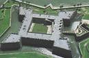
Marcos took twenty-three years to build but, once in place, stood as the town's stalwart defender. Amazingly, the Castillo, although attacked, was never taken by force. Since the beginning of its construction in 1672, the Castillo has played an important role as a strategic military post in the New World, and its‘ history is interwoven with that of Florida. Many flags have flown here during its illustrious history as an active military fortification, including the Spanish, the British , the Spanish again , the United States of America ,the Confederate States of America ,and finally the United States of America again. The Castillo was not the first fort built by the Spanish but was in fact the tenth, with the previous nine forts being built of wood. Following a pirate attack on St. Augustine in 1668, the Queen Regent Mariana made the commitment to have a masonry fortification built to defend the city and port. The founding of Charles Town (Charleston) in 1670 by the British less than two-day's sail from St. Augustine further emphasized the need for a stronger fort. Construction of the fortress that would become the Castillo de San Marcos was begun in October 1672.

For this new fort the engineers chose to use a local stone called "coquina". The name means "little shells" and that is exactly what the stone is made of-- little shellfish that died long ago, and their shells have now become bonded together to form the rock, a type of limestone. The coquina rock was quarried from Anastasia Island across the bay from the Castillo, and after rough shaping had been done, was ferried across to the construction site. The mortar to bond the blocks to each other was made on the construction site by baking oyster shells in kilns until they fell apart to a fine white powder called lime. The lime was then mixed with sand and fresh water to produce the mortar that still holds the Castillo together today. After 23 years of work, the Castillo was declared completed in 1695. It had its first test when British forces laid siege to the city in early November, 1702. At the start of the siege the people of St. Augustine crowded into the Castillo to take shelter. Over 1200 civilians and 300 soldiers of the city would remain within the walls for almost two months as the British troops occupied the town. The British cannon had virtual no effect upon the soft coquina walls, which merely absorbed the shock of the hits with little damage. The siege was finally broken by the arrival of a relief fleet from Havana that trapped the British ships within St. Augustine's harbor and forced the British to burn their ships to prevent their capture by the Spanish. As they withdrew from the area, the British put the city to the torch just as their countryman Sir Francis Drake had when he burned the city in 1586. After the 1702 Siege, it was decided to improve the Castillo and fortifications of the city of St. Augustine itself. With these improvements to the city, coupled with those to the Castillo, St. Augustine became a far more difficult city to attempt to take. In 1740 General James Edward Oglethorpe laid siege to St. Augustine from the newly established English Colony (in disputed territory) of Georgia. Oglethorpe placed troops and cannon batteries on Anastasia Island to fire on the city and the Castillo. He hoped that a sustained bombardment and blockade of St. Augustine would cause the Governor of Florida, to surrender the city and fortress to the British. The English guns fired on the Castillo, but were unable to breech the walls and Oglethorpe was unable to organize an assault on the Castillo. With the dawn of the 38th day of the siege, the citizens of St. Augustine saw that the British had withdrawn from the area.

It was not until 1763 that Spain ceded Florida to England in order to regain the capital of Cuba, ushering in twenty years of British rule in Florida. This period coincided with the American Revolution, during which Florida remained loyal to the Crown. In 1783, under the Treaty of Paris, Florida was returned to Spanish rule for a period of thirty-seven years. The Spanish departed for the last time when Spain sold Florida to the United States of America. At a colorful military ceremony on July 10, 1821, US troops took possession of the territory and Spain relinquished control of Florida forever. In 1845, Florida became the twenty-seventh state admitted to the Union. The Castillo de San Marcos was renamed Fort Marion in honor of a Revolutionary War hero Francis Marion (The Swamp Fox), and the capital of East Florida was moved from St. Augustine to become part of the state capital in the new town of Tallahassee.

The town had finally begun to prosper when the American Civil War broke out in 1861. Although Florida had seceded with the rest of the Confederacy, St. Augustine was occupied by Union troops throughout most of the conflict. When the war ended in 1865, the town was three centuries old. The wars end brought speculators and land developers to Florida along with the beginnings of the visitor industry. The arrival of Henry Flagler in 1885 marked the beginning of a golden era for St. Augustine that extended through 1914. Enticed by the city's temperate climate and unique ambiance, Flagler saw great potential for St. Augustine as a popular winter resort and playground for rich Northerners. A co-founder of the Standard Oil Company with John D. Rockefeller, he immediately put his vast fortune to work building his dream. He constructed two lavish hotels, the beautiful Alcazar, and his masterpiece-the Ponce de Leon. These hotels allowed St. Augustine to accommodate the wealthiest of travelers with luxurious lodgings and a fine array of leisure activities. His Florida East Coast Railway ensured a transportation link between New York and St. Augustine, and he built a two-story depot to properly receive arriving guests. Flagler was also responsible for building the town's hospital, city hall, and several churches. Flagler expanded his dream south toward Palm Beach when he moved there in the early 1900's, but had given St. Augustine an era of prestige and prosperity - the effects of which are still evident today.

Leaving the fort behind, we crossed the St. Johns River and camped at Anastasia State Park. Florida has an outstanding state park system. The facilities are clean, well maintained, and offer a welcome oasis to for weary travelers such as us. We spent a good deal of time walking along the beach, learning about the sea turtle habitat, manatees and enjoying another splendid sunset. The wind was beginning to pick up, and we were told that a cold front was heading our way. We naively assumed that it would mean a bit of morning chill and some clouds. Imagine our surprise the next day when we awoke to winds gusting to over 40 miles an hour and threatening skies. Fortunately it was a north west wind, and we were heading south. If it didn’t rain, it was going to be one fast day down the coast.

Thursday, November 09, 2006

Fountain of Youth

Continuing south from Amelia Island, we followed a route that essentially kept us either on or very near the Atlantic coast, skirting the Jacksonville metro area as best we could. Jacksonville is the largest city (in total area) in the US, and the only way to avoid the sprawl was to pretty much hug the coast, which is how you pass through on the Adventure Cycling route. We soon began to appreciate the value of the state and county parks in the area, because without them it would be one continuous real estate development after another for the next 300 miles. Like every other coastal area we encountered on our expedition, the land was either developed, under construction, or available to those with enough money to purchase their own “piece of paradise”. To be sure, there are pockets of undeveloped tracts to be found as well as a few small communities that appear to have been skipped over or frozen in some sort of 1960s time warp. But overall, construction activity and development seemed to be bustling and the price of real estate, especially along the water, seemed astronomical by our standards.

The ACA map tells you to “expect urban cycling conditions” in the coastal beach towns. What they mean is that in many of these communities you are bicycling through both old and new neighborhoods, down narrow alleys, through parks and beach shopping areas...observing a real oleo of homes, shops, high rise apartments, duplexes, beach rentals...it was truly fascinating. We became enthralled with the town of Atlantic Beach and decided to splurge and spend the night at the pastel painted Sea Horse Motel right on the ocean. The town was more funky than fancy, having an eclectic mixture of restaurants, a few popular watering holes and a good laid back feel. It was a wonderful interlude and a well earned respite to get us ready for our final push south.

The next morning we weaved our way through the towns of Neptune and Jacksonville Beach, and found ourselves pedaling along a beautiful bike path in the posh town of Pointe Vedra with its manicured landscapes, resorts, golf courses and multi million dollar homes. Leaving that behind, we rode through the Guana River State Park for the next 20 miles or so. It brought back great memories, reminding us of our time spent on the Outer Banks of North Carolina, with the surf pounding on our left (east) and the marshes and tidal plains to our right. It was a warm, windy day, and we stopped a number of times to soak up the ambience as well as take a few quiet walks on deserted beaches. We could have stayed there longer, but we knew that we had to get on and visit a bike shop. Olga had developed a severe “creak” in her headset. Matt had been noticing it for quite some time, and would periodically tighten up the bolts, but now he was getting concerned that something “serious” was going on that was affecting the steering and handling, and we needed professional, or maybe supernatural help. St. Augustine was the logical place.
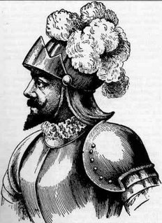
According to tradition, the natives of Hispaniola, Puerto Rico and Cuba told the early Spanish explorers that in Bimini, a land to the north, there was a river, spring or fountain where waters had such miraculous curative powers that any old person who bathed in them would regain his youth. Juan Ponce de Leon (1460-1521), who had been with Columbus on his second voyage in 1493 and who had later conquered and become governor of Puerto Rico, is supposed to have learned of the fable from the Indians. The fable was not new, and probably Ponce de Leon was vaguely cognizant of the fact that such waters had been mentioned by medieval writers, and that Alexander the Great had searched for such waters in eastern Asia. A similar legend was known to the Polynesians, whose tradition located the fountain of youth in Hawaii.

As described to the Spanish, Bimini not only contained a spring of perpetual youth but teemed with gold and all sorts of riches. In that age of discovery, when new wonders and novelties were disclosed every year, not only the Spanish explorers but also men of learning accepted such stories with childlike credulity. Ponce de Leon, like most of the other early Spanish explorers and conquerors, was looking primarily for gold, slaves and other "riches," and no one knows if he actually put much stock in the fable of the fountain of youth, if he had heard about it at all. On March 27, 1513 after searching vainly for Bimini among the Bahamas, Ponce de Leon sighted the North American mainland, which he took to be an island, and on April 2 he landed somewhere on the eastern coast. Nobody knows for certain where he first set foot on Florida soil. Some suppose that it was north of St. Augustine, while others think it was as far south as Cape Canaveral. Either because the discovery was made during the Easter season, or because he found flowers on the coast, or for both reasons, he named the country La Florida. In Spanish, Easter Sunday is la pascua florida, literally "the flowery passover." "And thinking that this land was an island they named it La Florida because they discovered it in the time of the flowery festival."

For over 2400 miles, Olga has been our stalwart companion with nary a complaint. We've subjected her to torrents of rain, mud, sand, grit, salt air, pot holes, curbs, gravel, broken glass and other maladies with nary a complaint on her part. She has performed admirably and has exceeded all our expectations. Her last visit to a bike shop was in Washington DC, and it was time to give her some well earned TLC. And as we would soon discover, it wasn't a moment too soon.

Wednesday, November 08, 2006

Two Different Worlds

There was no marching band to greet us, no ticker tape or F-16 flyover, heck, not even a "Welcome" sign. But nothing could have dampened our spirits as we crossed into Florida at 10:22 AM on our 60th day of riding. The computer told us that we had travelled 2451 miles, and while we were understandably excited, we were acutely aware that the trip was far from over. There were still 10 or more good days of riding left to traverse the 400+ miles to Mom's house.

The first place we stopped was at the Florida State Agriculture inspection station to get a highway map and have the officer take our picture. Throughout the trip, we have taken very few photos of us "together" on Olga. But we felt we needed this one as a momento of an incredible journey. Assuming it comes out ok, it will probably grace our Season's Greeting card for this year.

Officer J. C. Whitten was most gracious, taking our photo and reviewing our maps and route, commenting that we needed to take great care between Callahan and the coast, as there would be lots of trucking (especially logging), congestion, and a high volume of traffic to contend with. We knew that there would be some rough sledding, and realized that our days of pedalling down quiet 2 lane country roads would soon be coming to an end. We just had no idea how abrupt the change would occur. He bid us safe journey, and we pushed off to conquer our 13th and final State.

The route to Callahan was relatively easy going. There were a number of logging trucks to contend with, but they generally gave us wide berth, and since there was little vehicular on the roadway, it was a pleasant introduction into the Sunshine State. All of that changed the moment we pushed off from Callahan onto A1A/200 heading due East. We've been to Florida before and have driven A1A in the southern part of the state along the coast, but this was decidedly different. The next 25 miles were as tense and nerve wracking as any section we've ridden on the trail.

The maps do give you a heads up that traffic will be heavy and shoulders may be "inadequate or non-existant". What they didn't prepare us for was the shear volume of logging trucks...one right after another...that would go whizzing by at 60 mph. More often than not, there was a shoulder to ride on, but often they are strewned with debris, in need of repair, or disappear, changing into a right turn lane into a shopping mall or subdivision. It was like riding a bike in a video game. Vehicles were coming at us from virtually every direction. People were in a hurry and we were in the way. The signs told folks to "Share the Road" with bicycles, but this was one of those segments of the route that were simply about getting from one place to another. Our goal for the evening was the Lofton Creek campground just east of Yulee. We arrived about 30 minutes before dusk with frayed nerves and tired legs. Our greeting came as quite a shock.

Mary Ellen went to check in and returned to the bike with a distraught look. While the map directory showed this to be a campground, she was informed that they didn't allow tents. There were about 40 RVs crammed into a small space and it was apparent that the "campground" was actually more of a semi permanent RV housing "development" located right next the noisy highway. And these were not $300,000 motor homes. It was readily obvious that the folks in this campground were living there, somewhat like a modern day hobo village. The RV's were of many different shapes and sizes. Some where permanently "moored", surrounded by a porch. All had definitely seen better days. This was their "home".

We had virtually no options available. There was no way we were going to get back out on the highway in the quickly fading light. We put on our best puppy dog looks, and asked if it would be ok to simply find a patch off ground, pitch our tent, and be gone with the morning sunrise. We even pulled out the "We rode all the way from Maine and never encountered anything like this" gambit, hoping the owners would have pitty on us. After a few tense moments of silence we were told to find a spot near the rec room and set up camp there. We slipped them $20 cash to consumate the deal, thanking them profusely. We lucked out again.

The next morning we arose a 6 AM and broke camp as quickly as we could. We wanted to get going to beat the traffic. There was already alot of activityin the camp, as people were going about their business, and leaving for work. This was not the Florida vacation home for these folks. As we exited the campground, we rode past three kids who were slowly walking towards the highway to wait for the school bus. We greeting them with a "Good Morning" and received blank gazes in return. Maybe they were tired, maybe grumpy about going to school. We don't know. But it struck us that the sight of two people on a loaded tandem was a foreign concept to them. Their lives were so different from ours. We pondered what it would be like to grow up in the conditions they were living in, and what would become of these kids. It was a harsh wake up call to the day, and we rode in silence for the first 30 minutes or so, deep within our own thoughts.

The map indicated we had about 8 miles to go before A1A split off of highway 200, heading south on Amelia Island. 200 continues east with its terminus at Fernandina Beach, which has two large paper mills and a port which explains why there were so many logging trucks on the road. Mills consume trees...large volumes of them...and the pines of southern Georgia and north Florida seemed like they were being sucked into Fernandina to feed the mills. As soon as we crossed over the North Amelia river onto the island our world dramaticly changed.

Turning right onto A1A, the trucks were gone. We were greeted with a beautiful bike lane and as we rode a bit further, we started to see the manicured greenery of the nearby resorts, golf courses, and homes. We were back on the Atlantic Coast and into a world of retirees, vaction goers, construction workers, and housing for people of means. Since we had left camp before breakfast we were famished and stopped at the first place we found. It was a local deli, serving fresh hot bagels, coffee...all the big city trappings. It was in stark contrast to where we had been just an hour before. This was a dream world compared to what the folks were living in back at the campground. The TV was on in the restaurant. We've been in a number of establishments that have the Weather Channel or ESPN on. But this place had two plasma wall units tuned into MSNBC, with the stock ticker zipping across the screen and the talking heads opining on the next hot stock. It was another wake up call for us. We have seen incredible wealth on our trip, and have encountered some that have been less fortunate. It appears to us that the gap between the "haves" and the "have nots" is widening, and it became more evident as we rode the Florida coast.

Sunday, November 05, 2006

The Land of the Trembling Earth

Outside of Odum, we were in store for a special treat. A little over 5 years ago, through the magic of the Internet, Matt had reconnected with Linda Kline, a childhood friend of his from his summer camp days who has livesd in Atlanta for the past 20 years. They had been conversing back and forth by email, and about 2 1/2 years ago concocted a plan to meet "somewhere in Georgia". We never realized at the time that "somewhere" meant a 4 hour drive from Atlanta, but as the day of the redezvous approached, we coordinated schedules and spent a wonderful evening together with Linda and her husband Walt. It's amazing how easily old friends can reconnect, and even after nearly 40 years feel comfortable and at ease with each other. That night we rode in their van through the Georgia countryside to a local backwoods steakhouse that reminded us of "The Marysville House" near our home in Helena. Down a clay road, no lighting or signs pointing the way...a true local hang out. Conversation came easily as we talked about our trip, their lives, and all of our collective hopes, dreams and desires for the future. It was another one of those special moments that we will remember about our trip, and look forward to hosting them in Montana in the near future.

The Biggest and the Best
The last big "landmark" for us in Georgia would be the Okefenokee Swamp. For two days we rode, observe the subtle changes in the landscape. Farm land and slight rolling hills gave way to scrub pine forests and logging trucks. It looked as if we had gone back into South Carolina, except that the trees were a heck of a lot skinnier, and the trucks were more numerous. We were making a bee line south to Folkston, which is the gateway community to the swamp and national wildlife refugee. We knew we were close when we started seeing billboards and alligator logos on the buildings. Folkston is a pleasant community that for us had special significance because it was the first "real" grocery store we had seen since Statesboro, some 200 miles ago. After chowing down on a hardy lunch buffet (let's just say we got our money's worth) at the local diner, we stocked up on our essentials. We did choose to forgo the alligator tail and frog legs that were on special in the meat department, opting instead for chicken. Anyway, doesn't it all taste like chicken?

The Okefenokee swamp remains one of the oldest and most well preserved freshwater areas 
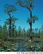
in America and extends 38 miles north to south and 25 miles east to west. Okefenokee is a vast bog inside a huge, saucer-shaped depression that was once part of the ocean floor. The swamp now lies 103 to 128 feet above mean sea level. Native Americans named the area "Okefenokee" the "Land of the Trembling Earth", because of the peat deposits (up to 15 feet thick) which cover much of the swamp floor. These deposits are so unstable in spots that trees and surrounding bushes tremble by stomping the surface. The slow-moving waters of the Okefenokee are tea-colored due to the tannic acid released from decaying vegetation. The principal outlet of the swamp, the Suwannee River(of Stephen Foster fame) , originates in the heart of the Okefenokee and drains southwest into the Gulf of Mexico. The swamp’s southeastern drainage to the Atlantic Ocean is the St. Mary’s River, which forms the boundary between Georgia and Florida. The swamp contains numerous islands and lakes, along with vast areas of non-forested habitat. Prairies cover about 60,000 acres of the swamp. Once forested, these expanses of marsh were created during periods of severe drought when fires burned out vegetation and the top layers of peat. The prairies harbor a variety of wading birds: herons, egrets, ibises, cranes, and bitterns.

Native Americans inhabited Okefenokee Swamp as early as 2500 B.C. The last tribe to seek sanctuary in the swamp were the Seminoles. Troops led by General Charles R. Floyd during the Second Seminole War, 1838-1842, ended the age of the native americans in the Okefenokee. The Suwanee Canal Company purchased 238,120 acres of the Okefenokee Swamp from the State of Georgia in 1891 to drain the swamp for rice, sugar cane, and cotton plantations. When this failed, the company began industrial wetland logging as a source of income. Captain Henry Jackson and his crews spent three years digging the Suwannee Canal 11.5 miles into the swamp. Economic recessions led to the company’s bankruptcy and eventual sale to Charles Hebard in 1901. Logging operations, focusing on the cypress, began in 1909 after a railroad was constructed on the northwest area of the swamp. More than 431 million board feet of timber were removed from the Okefenokee by 1927, when logging operations ceased. It became "protected" in 1937, and it is now one of the largest wilderness areas east of the Missisippi.By this time, numerous squatters and others had come to the swamp and even though they never really owned the property they were on, had to be removed from "their" property by the Federal government. It was a difficult time for all involved.

The best way to see the swamp is from a boat, and we signed up for a guided tour that tooks us through the historic Suwannee Canal drifting through a tangled forest of bay, cypress, pine and shrubs, then out into the open expanse of Chesser Prairie. Our guide Joey was a 6th generation "Swamper", and shared his knowledge of the swamp’s natural and cultural history, regaling us with interesting swamp stories and identify plants and wildlife along the way. We encountered egrets, herons, , red-shouldered hawks, and of course, numerous American alligators.

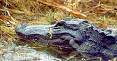
The American alligator is a member of the crocodile family, whose members are living fossils from the Age of Reptiles, having survived on earth for 200 million years. However, the alligator can be distinguished from the crocodile by its head shape and color. The crocodile has a narrower snout, and unlike the alligator, has teeth in the lower jaw which are visible even when its mouth is shut. In addition, adult alligators are black, while crocodiles are brownish in color.

Today, alligators are found throughout the Southeast, from the Carolinas to Texas and north to Arkansas. As during the Reptile Age, alligators live in wetlands, and it is this vital habitat that holds the key to their continued long-term survival. Alligators depend on the wetlands -- and in some ways the wetlands depend on them. As predators at the top of the food chain, they help control numbers of rodents and other animals that might overtax the marshland vegetation.
The alligator has a large, slightly rounded body, with thick limbs, a broad head, and a very powerful tail which it uses to propel itself through water. The tail accounts for half the alligator's length. While alligators move very quickly in water, they are generally slow-moving on land, although they can be quick for short distances. Alligators reach breeding maturity at about 8 to 13 years of age, at which time they are about 6 to 7 feet long. From then on, growth continues at a slower rate. Old males may grow to be 14 feet long and weigh up to 1,000 pounds during a lifespan of 30 or more years.

They'll eat eat just about anything, but primarily consume fish, turtles, and snails. Small animals that come to the water's edge to drink make easy prey for the voracious alligator.
The alligator's greatest value to the marsh and the other animals within it are the "gator holes" that many adults create and expand on over a period of years. An alligator uses its mouth and claws to uproot vegetation to clear out a space; then, shoving with its body and slashing with its powerful tail, it wallows out a depression that stays full of water in the wet season and holds water after the rains stop. During the dry season, and particularly during extended droughts, gator holes provide vital water for fish, insects, crustaceans, snakes, turtles, birds, and other animals in addition to the alligator itself. Sometimes, the alligator may expand its gator hole by digging beneath an overhanging bank to create a hidden den. After tunneling as far as 20 feet, it enlarges the end, making a chamber with a ceiling high enough above water level to permit breathing. This is not the alligator's nest but merely a way for the reptile to survive the dry season and winters.

And although you could have fooled us, the swamp and the entire southeast part of Georgia were in the grip of a rather serious drought. The water level of the swamp is totally dependent on rainfall to replenish itself, as no rivers flow into it, and was down significantly. Normal year to date rainfall is 50 inches, and as of now, heading into the "dry" season, only 35 inches has come down. The lack of hurricanes or major storms to visit the area was a welcome relief to homeowners (and their insurance companies) but had become a serious concern. The locals talked about how "brown" everything seemed to them, although to our untrained eye, it still looked mighty green to us.

We camped that night at a private campground just outside the refuge. We were a bit taken aback at the $25 price tag for the opportunity to pitch a tent, but in a way we had become spoiled. In all the states until Virginia, this would have been slightly belowthe average tariff. Once we left the Cape Hatteras region, prices of $15~$20 became the norm. In most of rural Georgia the prices had dropped to $7~$10, so our sticker shock needed to be put into perspective. After all, we were in a prime "tourist" locale, and with the Florida border just a few hours away, we figured that prices would be rising. The showers were clean, the crickets and frogs serenaded us, and with the moon nearly full, we cooked a meal repleat with fresh vegetables and a hardy ration of wine. We'd be crossing into Florida in the morning, and it began to really sink in that our journey was nearing it's end. The smell of the nearby swamp was noticeable. We had become familiar with, but never accustomed to the smell of "Swamp Gas" over the past month. "Swamp Gas", sometimes called "will-o-the wisp" or "foxfire" and even known in some quarters as "wetland flatulence" is a naturally occurring phenomena caused by decaying organic matter transforming into a gaseous state and on extremely rare occasions takes on certain properties of luminescence. In the 1950's many UFO skeptics used this uncommon swamp gas occurrence to dismiss numerous sightings of weird lights and objects in the sky. It reminded us of the odor we encountered along the banks of the Delaware River in New Jersey and Pennsylvania from the recent floods. It's distinct and definitely not a pleasing smell, put something you get use to (or "tune out) with time.

With standard time now back into effect, the sky gets light enough to start coffee and get breakfast going at around 6:15 or so. We broke camp by 8:00 and headed due south to St. George, located in the middle of the Georgia "panhandle". Actually, when you look at the map, Georgia is seems shaped more like a large kitchen cleaver, with a little finger of land jutting out along the Florida border forming the handle. The aforementiioned St. Mary's River that flows out of the swamp forms the southern border of the state, and after refueling at Rhoda's Cafe on a cheese omelet and grits (along with 38 cent coffee) we turned due east to cross into the "Flowery Land" and our final state of the trip. We were psyched, proud and exhilarated. Florida was ours for the taking! During our journey many folks commented to us that it should be easy, because, after all, from Maine to Florida is all downhill on the map. Now we were beginning to believe that maybe, just maybe, they were right.

Nutritionists have an Uphill Battle


Like all the states visited so far, Georgia has had a rich and colorful history. Spanish and French visited the coastal areas in the 1500s as part of their struggle for supremecy in the New World. However once again, it was the British that established a permanent presence. Georgia was the last of the 13 British colonies established on the Atlantic seaboard. It was founded by James Edward Oglethorpe with 114 original settlers on February 12, 1733, at the present site of the city of Savannah. Oglethorpe was noted as a philanthropist and for his benevolence, including helping children and defending seamen against impressment (being forced into service against one's will). It was his work on the Prison Discipline Committee that brought him in contact with the idea of creating a colony of debtors in the New World. Proposed by a number of writers and in at least one book, the concept gained some acceptance before Oglethorpe became a driving force in the movement. As more people settled in the colony of Georgia, the Spanish in the Florida area became increasingly uneasy at the growing British presence. On July 7, 1742, Oglethorpe, then "General and Commander in Chief of the Forces of South Carolina and Georgia", defeated the Spanish at the Battle of Bloody Marsh on St. Simons Island, removing the Spanish threat to Georgia. In 1743 General Oglethorpe sailed for England never to return to Georgia. During the Revolutionary War, many Georgians still felt loyalty to England. Therefore, the war was fought not only between American and British forces, but also between citizens who became revolutionaries, the Whigs, and those still swearing allegiance to the king, the Tories.

Georgia suffered both a loss of population and considerable physical destruction because of the Revolution. In time, settlers, attracted by the availability of land, moved from the other states-some being lured by an additional tracts of western land opened through a series of treaties with Creek and Cherokee nations. The desire for land, and later gold, created a swift expansion beyond the old frontier, carrying with it increased trade along rivers and migration of people along new roads into the wilderness. The primary basis for this new growth and economic expansion was the production of cotton thorough the slave labor system. In 1860 the national debate over the extension of slavery into new territories reached a crescendo. Following the election of Abraham Lincoln as president, a special state convention voted on January 19, 1861, to secede from the Union. Only a few months later Georgia formally joined the Confederate States of America. Georgia did not suffer direct devastation from the war until 1864 when General William Tecumseh Sherman advanced though Northern Georgia in the previously mentioned March to the Sea. During the war years, Georgia lost nearly 120,000 men and boys in battle as well as much of the state's material wealth. The rebuilding of the state afterwards was a slow and painful process. There were political conflicts between the newly enfranchised black citizens who, for the first time, were allowed to hold seats in the Legislature, and the prewar social structure, which sought to minimize the changes it had to accept in its traditional way of life. Georgia's economy was also crippled because of its heavy dependence on cotton production at a time when world market prices were are historically low levels.

Following World War II, the pace of industrial growth became more apparent. Atlanta, begun in the mid-1880's as a transportation center, gained recognition also as a commercial, financial, and cultural center for the Southeast. New industries developed in Georgia, and others moved from outside into he state. Meanwhile, rural Georgia was revitalized as Georgia's farme
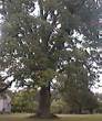
rs, who had been driven from cotton production by the destructive boll weevil, diversified their planting operations and adopted new agricultural techniques. Georgia is a leader in peanuts and pecan production. We spent the good part of two days riding through a landscape of pecan orchards, tobacco farms and cotton that was nearly ready to harvest. It was fall bicycling at it's best, with warm days, cool nights, and little traffic.

Generally speaking, we were riding in a corridor about 30~40 miles from the Atlantic Coast. The small towns we passed through were spread 15~20 miles apart, and there was very little sign of commerce other than the occassional general store or gas station. There were no restaurants to speak of, and the few places we did come across served variations of deep fat fried chicken, pork rinds, or fish. If you wanted something that wasn't fried...well, there always was some form of pulled pork available, served on a squishy white hamburger bun. The "lunch box" special generally contained two pieces of fried something along with a choice of two sides (stewed vegetables like pole beans, cabbage, okra, or lima beans). We also found that in some places, macaroni and cheese was considered to be a vegetable. At the larger food outlets, the menu also featured fried gizzards and livers. Being a nutritionist, Mary Ellen felt compelled to take photos of the menu offerings, along with snapshots of the different "parts" being sold in the few grocery stores we would come across. We couldn't find fresh produce, fruits or any selection of bread to speak of. The diet sure was different than what we were accustomed to. In fact, Matt commented that some of the butcher selections reminded him of his travels in mainland China, where they pretty much consume all parts of an animal, and you're never really sure of what it is that you're eating. Let's just say that we ate a lot of pasta for dinner and oatmeal or grits for breakast.

Many of the stores in these small towns had gone out of business. When we stopped to ask where one could buy groceries, we often were told that the closest place was the new "Super WalMart" about 15 miles down the road. We could see first hand the impact that these supercenters have had on these communities. The commercial center (small as it was) of these towns had disappeared. People voted with their pocketbooks, and took their business down the road. You can't blame them really, and it's a story being played out across rural America. But it felt as if the life blood had been sucked out of those towns and left us with a touch of longing for what used to be. But progress, such as it is, doesn't stand still...and neither did we.

We found ourselves riding at an efficent but steady pace averaging over 11 MPH, which for us was pretty darn good. Having set our sights on Florida, we rode with a sense of purpose and confidence. 12 states down, one to go, and we were still having the time of our lives. Now if we could just find some whole wheat bread for our peanut butter, all would be right with the world.

Peachy Keen In Georgia

Upon entering Georiga, the change in topography was both startling and refreshing. The terrain became much more varied, opening up to reveal irrigated fields of cotton, peanuts, tobacco, hay and even a few cattle ranches. The soil seemed to be a combination of sand and clay, but apparently quite fertile. We had not seen farms of this size since our time in Virginia, and even though the map indicated only a few hundred feet in elevation, it was in stark contrast to what we had been experiencing for the past two weeks. While we still rode by swamps, they were much smaller in size, and far less wooded. We actually encountered a few hills that required some concentrated effort to climb, rediscovering muscles that had not been used for a long, long time. Even so, it was nothing like the "hills" of New England and the mid-Atlantic states. We were making good time, and thoroughly enjoyed the route as it took us on extremely low traffic county roads that were in very good condition. We needed to finish 70 miles before an expected rainstorm would hit, and by 4 PM with clouds building and the wind picking up, rolled our way into Statesboro, home to Georgia Southern University and the largest community we would pass through on our trip south.

Although it is true that Statesboro and Georgia Southern University have historically grown and continue to grow in tandem with one another, the city cannot be considered a true college town where the community is built around a college/university, Statesboro was a well established community whose civic leaders built and continue to build the university to this day. Although the university is run by the state government, it has very strong ties to various citizens of Statesboro. Statesboro-Bulloch County offers a diversified array of employment opportunities in agriculture and industry. However, the "Town-Gown" relationship is very real, although not as intense as it could be since a large portion of the student population are also Statesboro natives. Because Statesboro is like a college town, there are a number of restaurants, bars and a couple of coffee houses where we could actually take care of our "latte" craving for the first time since Charleston. Statesboro may be familiar to music-listeners through the song "Statesboro Blues" written by Blind Willie McTelland covered by many other musicians, including Taj Mahal and the Allman Brothers Band. We found it to be an enjoyable oasis, and opted to spend the night in a motel room so we could spend time walking through the downtown area and splurging on a good old fashioned Southern bording house meal. My, my, those fresh homemade biscuits are sure tasty!

Statesboro was "visited" but not destroyed by Union Soldiers during the Civil War as part of General William T. Shermans' infamous "March to the Sea", which still engenders bitterness even to this day. The Union's goal was to demonstrate to the Conferederate citizens that their goverment was no longer capable of protecting them. It began with the burning of Atlanta on November 15, 1864, and ended with the caputre of Savannah on Dec. 21. It is said that Sherman wired President Lincoln on the next day, offering the city and its many thousands of cotton bales to Lincoln as "a Christmas gift".

The campaign was designed to be similar to Grant's innovative and successful Vicksburg campaign in that Sherman's armies would reduce their need for traditional supply lines by "living off the land" after their 20 days of rations were consumed. Foragers, known as "bummers", would provide food seized from local farms for the Army while they destroyed the railroads and the manufacturing and agricultural infrastructure of the state. The twisted and broken rails that the troops wrapped around tree trunks and left behind became known as "Sherman's Neckties". Furthermore, the army would be out of touch with the North throughout the campaign. Sherman's scorched earth policies have always been highly controversial, and Sherman's memory has long been reviled by many natives of Georgia, but slaves, many of whom left their plantations to follow his armies, welcomed him as a liberator. The March to the Sea is considered by many historians to have demonstrated Sherman's superb command of military strategy, and his commitment to destroying the Confederacy's ability to wage further war may well have hastened the end of the conflict.

That night we decided to forgo a visit to Savannah and continue to travel south. To take the spur road into Savannah would have required two additional days of riding, as well as a day or two for sightseeing. Given that the nights were not getting any warmer, and with daylight savings time soon to end, we opted to continue our "March to the South" and more friendlier climes. Even though we were traveling with no set itinerary or time schedule, we felt that Florida was calling us. So under a blustery and threatening sky we left Statesboro behind and cycled off into the rolling countryside to find out what awaited us around the next bend.

Wednesday, November 01, 2006

Carolina in our Minds

Our final day in South Carolina took us through more of the same...mainly swamps and forests. The morning chill lifted, and it became a brisk but wonderful day for bicycling. There was no traffic to speak of at all, and for the first time in what seemed like eons, there were actually small grades to ride. Nothing that required much effort, but a welcome change from the never-ending flat lands.

Since we had the road to ourselves, we spent a long time discussing our thoughts and feelings about our journey through the Carolina's. One of the wonderful things about a tandem is the ability to easily communicate with your partner. There are times, especially in urban traffic situations when it is difficult to hear each other over the din. But our guess is that for 95% of the ride, we could easily converse in normal tones. There are radio communication sets for tandem riders on the market, but in our humble opinion they serve no real purpose.

We both shared the same observation on the racial diversity of the South. Being from Montana (where 94% or thereabouts of the people are white), we have very little interaction on a daily basis with African Americans. It was refreshing to converse with different people, although we both had difficulty with the increasingly heavy Southern drawl. We often found ourselves asking each other "what did they say?", and generally had to listen two times before we could truly understand. But, we discovered that they had the same problem with our accents, and we had a good laugh with a number of them about the "foreign" language we were speaking. In fact, we found it more difficult to understand the white folks than the black. Don't ask us why. We didn't notice any animosity on a face to face basis...only the occassional "get yer ass off the goddamn road" invictives as a pickup truck sped by. But nothing of concern, really. It seems to us that Southerns don't consider people from Montana as "Yankees", but as some people who talk with a strange accent that happen to live far away. It was an interesting experience.

We also learned that hurricanes play a major role in the lives of folks from Virginia on down the coast. Like forest fires in the West, people remember hurricanes, and know exactly when they occurred, and the damage done. "Floyd, Irene, Ben, Inez"...all have meaning to those who lived through them. All through the lowlands there are "Hurricane Evacuation" route signs, meaning that these storms are not isolated occurances, but an accepted "risk" to living there. People often say to us that they could never live in Montana...it being too cold, or the risk of fire, or being eaten by a bear...that sort of thing. But after witnessing 10 inch downpours, seeing all the houses built on stilts, observing the "high water mark" road signs, etc. , we'll take cold over hurricanes any day of the week. You choose you're risk, and live with the consequences.

We've seen lots of roadkill on the trip, (which is something you notice on a bike) but about 30 miles from the Georgia border, we saw our first armadillo.

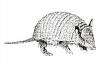
The armadillo first forayed into Texas across the Rio Grande from Mexico in the 1800s, eventually spreading across the southeast United States. Wildlife enthusiasts are using the northward march of the armadillo as an opportunity to educate others about the animals, which during the Great Depression were known as "Hoover Hogs" by down-on-their luck Americans who had to eat them instead of the "chicken in every pot" Herbert Hoover had promised as President. Armadillos are prolific diggers, and many species use their sharp claws to dig for food such as grubs, and to dig dens. The armor is formed by plates of dermal bone covered in small, overlapping epidermal scales called "scutes". This armor-like skin appears to be the main defense of many armadillos, although most escape predators by fleeing (often into thorny patches, which their armor protects them from) or digging to safety.

They have been officially declared, albeit with some resistance, the state small mammal of Texas where it is considered a pest and is often seen dead on the roadside. In the state of Washington, it is illegal to own an armadillo. Armadillos can be kept as pets, although they require moist ground in which to dig and catch insects. They are difficult to fully domesticate. They make common roadkill — jokingly described by some as "possums in a half shell" — and a burrowing nuisance to homeowners, cemetery caretakers and golf course superintendents. Armadillos have short legs but can move quickly, and have the ability to remain underwater for as long as six minutes. The North American Armadillo tends to jump straight in the air when surprised, and consequently often collides with the undercarriage of passing vehicles.

"Climbing" ( a gentle but steady rise) out of the Black Swamp, we crossed the Savannah River into Georgia, where we stopped at the "El Cheapo" (real name) gas station for a quick refreshment and mini celebration of sorts. Georgia had become the 12th state that we would traverse, and with one more to go, we actually began to feel as if the end was in sight.

We had learned a few days back that when asked the question "Where ya headin'?", it no longer sufficed to say "Florida". In 21st century terms, we were actually just a half day's drive on I95 to the Florida border. We found that people were now much more interested about where we came from, rather than where we were going to end up. After spending a brief respite talking with the patrons (who were mainly hunters), sharing stories, and listening to tales of hunting, fishing, and grumblings over federal management of wildlife areas, we bid adieu, mounted up once again and proceeded on.

Baby it's Cold Outside

It was around 2 AM or so when the silence was finally broken. "I don't know about you, but I'm FREEZING". Truly, it was the coldest evening of the journey. We would later come to find that the thermometer dropped to a brisk 34, missing the record cold for the day by just one degree. And, when you figure in the dew point (feels like temperature), it was plenty cold, and it was a damp cold to boot. We had no choice but to put on everything that we owned, including our rain pants and jackets. We spent the rest of the night in a fitful sleep, huddled together with hoods up, burying ourselves deep within our sleeping bags, hoping that the sun would soon come up.

It seemed like forever before the sky turned light enough to venture out of the tent, fire up the propane stove and get the coffee water going. There were still hot coals in the firepit from the night before, and Matt got the fire going again, which was a welcome relief. Being from a softwood state, we're not used to burning oak. It does take a while to get going, but the fire seemingly burns forever, and it gives off a warm, even heat. We were fortunate enough to have scrounged up some discarded pieces of live oak from some other camp sites. While we had seen Live Oak trees in Virgina and North Carolina, we were awe struck by their size, beauty and grandeur in SC.

Live Oak is a large spreading tree of the lower Coastal Plain from southeastern Virginia to southern Florida and to southern Texas. It normally grows in low sandy soils near the Coast but also occurs in moist rich woods and along stream banks. The trees often support many types of epiphytic plants, including Spanish moss (which is neither "Spanish" nor a "moss") which hangs in weeping garlands, giving the trees a striking appearance. Live oak is a fast-growing tree. Sweet edible acorns are usually produced in great abundance and are of value to many birds and mammals including wild turkeys, wood ducks, jays, quail, whitetail deer, raccoons, and squirrels. The yellowish-brown wood is hard, heavy, tough, strong, and is used for structural beams, shipbuilding, posts, and in places requiring strength and durability. This is why they were so valued by the early colonists and European sea powers. In recent times, the trees have been planted in cities. providing incredible beauty and shade from the searing summer sun. Live oak ranks as one of the heaviest native hardwoods, weighing 55 pounds per cubic foot when air dry. This weight or density makes it a good fuel wood although it can be very difficult to split. They grow broad and tall, with canopy spans similar to the Banyan trees found in the tropics.

The Live Oak trees were one of the most memorable aspects of our time in South Carolina. But on the whole, we had mixed emotions about the state. We enjoyed some wonderful solitude riding through the forests and swamps, but at times it became quite monotonous, almost dull if you must know the truth. We encountered warm, friendly people along the route, but also felt (for the first time) uneasy in a few situations. It's hard to put a finger on, but it seemed clear to us that some folks would rather not be seeing bicyclists on their road. We've had very few conflicts with autos or trucks, but in South Carolina we did feel less welcome than some of the other places we have visited.

For our last planned night in SC it was going to be another cold one. We had planned to camp at a KOA in Point South, located next to Interstate 95. Not exactly our ideal choice, but the only campground for miles around. For one of the few times since we left Maine, we were not looking forward to sleeping out and camping. On the frontage road to the campground we passed by an old dilapidated motel named the Budget Inn. It was clear that the last time someone put a dime in the place was around the time the interstate highway was being built. But they only wanted $36 for a room, and since the KOA was asking $32, it was a no brainer. We cooked dinner that night in the parking lot of the motel, and dined by candlelight in our room. It was warm and cozy, and we knew we needed to get an early start to the next day. We had decided to do another "70 miler" to get into Georgia and further south. If we couldn't sleep in the cold, maybe we could out run it!

The next morning, we took off before 8 AM, wearing our winter gloves and beanies. It was like riding in Montana in the early spring or late fall. It definitely was time to be proceeding on.

Tuesday, October 31, 2006

Doin' the Charleston

It was pouring rain (Warm Rain III) but we didn't care. We knew that with any luck, we'd be in Charleston by late afternoon with a roof over our heads and the opportunity for a night on the town. Our route took us directly through the Francis Marion National Forest. We were riding through a corridor of pines, rain splashing down, but with no traffic to speak of, it was rather smooth (albeit wet) sailing.

The Swamp Fox
For those that grew up watching "The Wonderful World of Disney" on black and white televisions, they're sure to recall the story of the man known as "The Swamp Fox". Francis Marion was an American revolutionary war hero, nicknamed the "Swamp Fox" by the British because of his elusive tactics. In 1761 he first distinguished himself as a lieutenant of militia by defeating some ambushed Cherokees. In 1775, Marion was elected to the South Carolina Provincial Congress as a representative. This Congress authorized the formation of two regiments, Marion was captain of the Second Regiment. In 1780 as a lieutenant colonel in the Continental service, Marion led an attack on Savannah. In May of 1780 Gen. Benjamin Lincoln surrendered Charleston to the British.In August 1780, Marion commanded guerrilla warfare against the Loyalists along the Peedee and Santee rivers. Marion chased away three Loyalist groups. Turning upon the British, Marion cut their supply lines, outran Sir Banister Tarleton's dragoons, raided Georgetown, retired to Snow's Island, and then again raided Georgetown.After the Continentals returned to South Carolina, Marion served as brigadier general of the militia under Gen. Nathaniel Greene. Aided by Continental troops, Marion finally seized Georgetown.

At the battle of Eutaw Springs on September 8, 1781, he commanded the militias of North and South Carolina and drove the British back to Charleston.Marion was quiet and moody, yet humane and forgiving. He rose from private to brigadier general because of his intuitive grasp of strategy and tactics. Daring and elusive, he usually struck at night and then vanished into the swamps and morasses of the South. Many believe that the character portrayed by Mel Gibson in the movie "The Patriot" is based on Marion and his exploits.

Arriving on the outskirts of Charleston, the wind picked up and the rain became intense. We sought refuge at a local pizza parlor where they owner took pity and offered shelter from the storm, free coffee, as well as a good slice of NY style pizza. A new bridge links Charleston with nearby Mount Pleasant (complete with a wide bicycle/pedestrian walkway), but to get there, we needed to traverse some 10 miles of urban congestion. Maybe if the sun was shining it would have been fine, but the roadways were flooded and we got out the state highway map to devise plan B which took us on a rather circuitous but very safe route to the bridge. As we pedalled up the ramp entry, the sky finally cleared, and we coasted our way into Charleston and our nights lodging at the "Not So Hostel" hostel.

We chose the hostel because it would be inexpensive and located within walking distance to the downtown historic district. In hindsight, it was not one of the better decisions we've made. Located in a "transition" neighborhood, our room was tiny, the bed matress had more lumps than bad mash potatoes, and we had to share a bathroom with three others. That was somewhat to be expected, but as we discovered after the fact, we could have booked a hotel room two blocks away for $65 and spared ourselves the aggravation. So it goes.

A Bit about Charleston
Much has been written about Charles Town, which was named in honor of King Charles II of England. King Charles was known for many things, but was most notorious for his womanizing and his lifestyle as a hedonistic pleasure seeker. His father was beheaded by the puritans for his exploits. It has been said the King Charles was "the father of his people, or at least, a great many of them." Founded in 1670 at Albemarle Point, early settlers were threatened by Spanish more than Indians, and Albemarle Point provided a vantage point from which to view any approaching vessels.

By 1690, Charles Town was America's fifth largest city. Initially, the population consisted mostly of English settlers, and later added many French Protestants called "Huguenots" as well as quite a few Irish.

Early Charles Town suffered a serious threat by murderous and thieving pirates, most notably Blackbeard. Blackbeard was apprehended and convicted in 1718 but quickly escaped. He was later captured and killed . Also threatened by Spaniards and Indians, it didn't take long for resentment to build against the English Lord Proprietors who were neither willing nor able to protect Charles Town from her attackers. Revolutionary activity began in Charles Town as early as 1719.

In spite of Charleston being referred to as "The Holy City", most likely because of the church steeples that distinguish the skyline, Charles Town was known more for its tolerance and decadence than religious fervor. In fact, the story line goes that there are 179 churches and over 200 bars in modern day Charleston, which seems like a good ratio to us.

Slavery was not a significant part of the first 30 years of Charleston history as she was mostly a trading town. By 1710, part of the very profitable trade and commerce in Charles Town involved the buying and selling of slaves which contributed significantly to early fortunes both from the trade of slaves and from planting using slaves.

Charles Town became one of the largest and wealthiest cities in America as the result of the trading of indigo, rice and slaves. African Slaves brought their knowledge of rice planting with them as well as the ability to survive the heat and disease. The same genes that made them prone to sickle cell anemia, made them resistant to malaria and yellow fever.

Charleston is known most for its charm and history; it's an experience that's difficult to convey. Charleston has a very unique story which there isn't time to tell here. The preseervation and restoration of the homes in the historic district is truly remarkable considering the history of the city. Charleston was devastated by several forces both natural and man-made, but probably nothing took more out of Charleston than the Civil War. With many buildings burned or severely damaged by the sustained artillery siege on Charleston, due to the economic destination that followed the Civil War, there was no money to tear down and rebuild. So Charleston remained in horrible condition for years, but with the original structures still intact. It is these structures that have been transformed into what is now known as one of America's most liveable and beautiful cities.


Trail Angel Marilyn
Good fortune smiled on us once again, as we had the pleasure of a great guide to the city. Our connection to Marilyn Durkee was through Mary Ellen's sister Donna. Mary Ellen had met Marilyn Durkee a few years ago when she was at a cooking school in France, but we were not prepared for her graciousness and hospitality during our stay. She drove us around the city, helping us take care of important chores, and was a fount of knowledge about the town and what it's like living in Charleston. She dedicated two days of her life to us, introducing us to her friends and city, and we were truly fortunate. Thanks Marilyn. You're an angel.

We were suprised at how vibrant the town seemed. There are three colleges located in Charleston, and the place was hoppin' with young folk. There were numerous restaurants to choose from (we did seafood and our first Carolina style barbeque), art galleries, museums...all the trappings of a live and thriving community. Our stay was short but fun filled. We were told that a cold front was coming in, and knew that we needed to continue our journey south. Leaving town by SR61, we rode passed three different historic plantations lined with some of the most spectacular live oak trees drapped with Spanish moss we had seen to date. Our destination for the evening was Givehans Ferry State Park, and we made it to the campsite with the last rays of sunlight in the western sky. The temperature was dropping, and we busily started to scout the area for firewood. It was going to be a cold, clear night, and a warming fire would be most welcomed.

Friday, October 27, 2006

2000 Light Years from Home

Let the record show that at 1:34 PM, 7 miles North of Chubby Checkers hometown (Andrews SC), on our 43rd day on the trip, the odometer registered 2000 miles! We stopped to hug, kiss, and celebrate with a well deserved banana break. Words cannot express the feelings we shared.

To add to the celebration, we were in the midsts of our record setting day. Between Conway and Charleston, the route passes through some of the most rural areas of the South Carolina lowlands. Swamps, bogs, forests and more swamps, punctuated every so often with a small hamlet or rural store. We found that in these communities, the old fashioned country store is THE place that people go. They're not fancy, and they certainly aren't offering specialty coffee drinks. In fact, we discovered the joys of chili dogs and boiled peanuts. The best chili dog to date was in Pleasant Hill, SC. While we saw no evidence of a hill, they sure did make a mean chili dog, with the request onions, cheese and other trimmings. Boiled peanuts are another treat that shouldn't be missed. Soft, tender...we both prefer the cajun over the original style. It is the lunch choice of champions!

Fueled by the local delicacies, we rode over 72 miles that day. It was sunny, the wind was to our back, and it was effortless. Our trial began when we tried to locate our camp site for the evening. The South Carolina highway map indicated that there was a campground near Jamestown, about 50 miles from Charleston. This was perfect as it meant we could be in the city the next day. What we didn't know was that the campground was 7 miles off route, 3 miles down a dirt road, and that it was the last day of deer hunting season with dogs. Apparently, in SC one can still hunt deer using canines in certain districts. We were not about to do "rough" camping in the middle of hunting season, but it still unnevered us to be riding along a road that had significant hunter traffic. Dog hunting seems a bit strange to us. The "hunter" puts a radio tracking collar on their hound and drives up and down the road holding an antenna out the window, trying to pick up the dogs signal. The animals are trained to herd the deer back toward the road, where they can be easy pickin's for the hunter. So much for fair chase.

We pedaled hard and fast, not wanting to be caught in a cross fire of some over anxious rifle man who had not yet filled his quota. Getting to the campground, we found the last site available, and spent a "unique" evening listening to the hum of propane power generators. These folks had enough juice going to light up a ballpark for a night game, but we weren't about to say anything. We spent a rather restless night, never really getting to sleep. After waiting a few hours after sunrise, we donned our brightess colors and rode the heck out of there towards Charleston. It was starting to rain but we didn't care. After all, it was going to be a "warm rain."

Not Identical Twins

You wouldn't think that there would be that much difference between North and South Carolina, but there you would be mistaken. The change became apparent as soon as we crossed the border. First thing we noticed was more litter along the roadside. We can only pozit as to why that might be, but for some reason, North Carolinians keep their garbage in the cars, and their Southern cousins seemingly toss it out the window. We also noticed that the road surface was rougher, and shoulders or accomodations for bicyclists were virtually non-existant (at least in this part of the state. It would change some as we moved southward). We had also started to observe Palmetto Pines in NC, but they were evident everywhere (including on the license plates) in SC. It gives a nice, almost tropical feel to the place.

A Long, Rich and Unique History

South Carolina stretches from the Atlantic Ocean to the Blue Ridge Mountains, containing 31,113 square miles. Fortieth in geographic area among the fifty states, it ranks twenty-sixth in population.

Spaniards explored the South Carolina coast as early as 1514. Spanish fears of French rivalry were heightened when Huguenots led by Jean Ribaut attempted to settle on what is now Parris Island near Beaufort in 1562. After Ribaut returned to France for reinforcements, the soldiers who were left behind revolted, built themselves a ship, and sailed for France the next year. The horrors of that voyage went beyond eating shoes to cannibalism before an English ship rescued the pitiful remainder of the French attempt to colonize here.

The Spanish built Fort San Felipe on Parris Island in 1566 and made the new settlement there, and made it the capital of La Florida Province. This was a good 50 years before Jamestown was settled. In 1587 after Sir Francis Drake had destroyed St. Augustine, the Spanish decided to concentrate their forces there. With the withdrawal from Santa Elena to St. Augustine in 1587, South Carolina was again left to the Native Americans until the English established the first permanent European settlement at Albemarle Point on the Ashley River in 1670.

King Charles II had given Carolina to eight English noblemen, the Lords Proprietors. The proprietors' first settlers included many Barbadians, and South Carolina came to resemble more closely the plantation economy of the West Indies than did the other mainland colonies. By 1708, a majority of the non-native inhabitants were African slaves. Native Americans, ravaged by diseases against which they had no resistance, last significantly threatened the colony's existence in the Yemassee War of 1715. After the colonists revolted against proprietary rule in 1719, the proprietors' interests were bought out and South Carolina became a royal province.
By the 1750s, rice and indigo had made the planters and merchants of the South Carolina lowcountry the wealthiest men in what would become the United States. Government encouragement of white Protestant settlement in townships in the interior and migration from Pennsylvania, Virginia, and North Carolina were to give the upcountry a different character: smaller farms and a larger percentage of German, Scots-Irish, and Welsh settlers. By 1790, this part of the state temporarily gave the total population a white majority, but the spread of cotton plantations soon again made African American slaves the majority.

Charlestonians were strong supporters of their rights as Englishmen in the Stamp Act crisis in 1765, and South Carolina would play a significant role when differences escalated into the American Revolution. Over two hundred battles and skirmishes occurred in the State, many of them vicious encounters between South Carolinians who opted for independence and those who chose to remain loyal to King George.

The first shots of the Civil War were fired in Charleston Harbor on April 12, 1861. Two days later the federal garrison in Fort Sumter surrendered to Confederate forces. Union troops occupied the sea islands in the Beaufort area in November, beginning the move toward freedom for a few of the state's slaves, but few military engagements occurred within the state's borders until 1865. One-fifth of South Carolina's white males of fighting age were sacrificed to the Confederate cause, and General William Tecumseh Sherman's march through the state at the war's end left a trail of destruction. Poverty would mark the state for generations to come.

Rapid expansion of the textile industry in the 1890s began the state's recovery from a share-cropper economy, but the boll weevil gave the Great Depression a head start here in the 1920s. The state’s poverty and racial practices caused many African Americans to seek opportunities in Northern cities; after 1920, South Carolina no longer had a black majority. The expansion of military bases during World War II and domestic and foreign investment in manufacturing in more recent decades have revitalized the state. The Civil Rights movement of the 1960s ended legal segregation and discrimination and began the incorporation of the state’s African Americans into the political and economic power structure of the state. In most recent times, tourism and retirees have become a driving force in the economy.

Our first day in the Palmetto State was quite a challenge. While the terrain was still flat, the headwind made it feel like we were pedaling uphill all day. It was a 3 gear wind, and there was no let up. Our moods turned foul, and tempers flared a bit. We've spent a lot of time together on this trip. In fact, people often comment that you really need to be in love to travel like this. Well, they're right...we are in love, but every once in a while the road gets the best of us. Today's disagreement was over what type of bread to buy. Imagine that, standing in the Piggly Wiggly bakery section in Conway SC, arguing over the merits of store bought bagels vs. squishy rolls. The disagreement was quickly settled when Matt did a 180 and headed to the wine section, letting Mary Ellen to choose. It seems ridiculous to even mention it now, but it's just another way to say that hard riding days take on a life of their own. The spat ended as quickly as it began, and we enjoyed another fine dinner, camping along the edge of the Big Cypress Swap on the outskirts of town, enjoying the stars under a clear, moonless sky.

Capt'n Sez...

A few minutes after we left the dock, Captain Sandy came down to greet us. Besides being a ferry boat captain with over 23 years of experience, he was also an avid bicyclist. We came to find out that he spotted us boarding the ferry, and as was his custom, wanted to personally welcome us aboard. He invited us up to the bridge, where we traded stories about cycling, and also learned about what it takes to become a ferry captain. He gave us a map of Southport (the town we would be docking at) and told us that it was definitely worth a few hours to nose around and visit. While we had not planned on it, when you're on a boat you need to follow the Captain's orders, so there was no argument coming from us. And, make no mistake, the Captain knew what he was talking about.

Southport has always attracted sailors, the earliest visiting the area in 1524 and 1526 were French and Spanish explorers. The first European vessel constructed in the New World was built on these banks of the lower Cape Fear River. The town still reaches out to ocean going vessels and Intracoastal Waterway cruisers. After the Civil War, businessmen tried to create a major southern port here by combining river transportation and railroads. The name Southport was chosen in 1887 as part of that promotional effort. Though the town never became a major port city, it did gain telegraph service and a coaling dock for steamships. It's a town close enough to Wilmington to reach the conveniences of a big city and college campuses, yet just out of reach of the interstate traffic. It has become home to a number of retiree's as well as people just trying to get away from it all. The "inner" city is replete with huge live oaks and other splendid trees, as well as Victorian homes. New housing developments were going in along the port area, but it still had a wonderful small town feel and charm. In fact, it was similar in many ways to towns we visited in Maine. We could have stayed longer, but needed to push on.

Leaving Southport we rode through more swamps and pine forests. We also passed a number of housing developments. At the time we had no way of knowing that for the next 100 miles or so we would see the same story repeated over and over...swamps or forests that were now the homes to retirees or vacationers. It seems that all of the coastal regions that we have visited are destined to be developed. Such is the way of progress, but we wonder where all the people and money come from, and what is being lost in the process.

Around the town of Shallotte, we came back to agricultural land and actually purchased some fresh sweet corn from a local farm stand. The route took us back across the intracostal towards Sunset Beach. There were numerous roadside seafood stands to choose from, and being that it was getting late in the day, it was time to stop and replenish our supplies. We stopped at Captain Jacks, a ramshackle kind of place on our side of the road. The Captain was a man of few words. When we asked a question, he replied with curt "Yep" or "Nope" responses. But he sure knew his seafood, and we left with a pound of sea scallops that turned out to be a real treat.

Our destination for the evening was Calabash, right on the border with South Carolina. We were 20 or so miles from Myrtle Beach, and could already see the influence of the development going on around it. We saw a number of developments that were identical to what you see in south Florida...lush, beautifully maintained golf courses and gated residential communities. In fact at last count, there are over 100 golf courses in the area...a true mecca for the golf inclined.

We camped at Captain Andy's Charter Boat and Campground on the banks of the Calabash (yes, named after the gourd that grows in abundance here) River. Captain Andy doesn't do charters anymore. At 70, he says he doesn't need the headaches. In fact, the developers would love to purchase his property, but as he says "Hell, the world don't need 'nother frickin golf course...and besides, where would I go? I love it here." Captain, we couldn't agree with you more.

We bid adieu to the Captain on the next morn. It was a clear, brisk day. The shrimp trawlers were returning to the near by docks fully loaded. Before pedalling off, Capt'n Andy gave us some of his hmegrown hot "peeter peppers" (use your imagination) and told us to expect 20 knot winds from the south. As our route took us due south the whole day, we figured that we'd be heading right into it. We're not sure how much a "knot" is, but as far as headwinds go, this one was a doozy. It was going to turn out to be a challenging day.

Wednesday, October 25, 2006

The Bike Gods Smiled Upon Us

Sometimes you’re good, and sometimes you’re lucky. Today we were the luckiest people in the world! It poured all night and into the morning. We dawdled getting ready, putting off the inevitable. We were certain that we were in for a good soaking, and with 50 miles to go to Wilmington, and not knowing what the road conditions might be, we were definitely not eager to get back on the bike. But by 9 AM we could wait no longer and suited up for the wet day ahead. As we were packing all our gear (which, by the way, we’ve become very adept at) the rain sputtered and then came to an abrupt halt. Talk about good fortune smiling on us. It didn’t rain a drop the rest of the day. The roads were awfully wet, and we wore our rain suits so we wouldn't get soaked by passing cars, but we were lucky indeed.

It was a hot and steamy day. In fact, we both noted that for the first time it felt like we were in the tropics. Surf City had that tropical feel and smell. We don’t know if that is because the Gulf Stream comes close to shore or what, but it sure felt different. Within an hour we were sweating to beat the band, and had to strip down to summer cycling attire. The rest of the day was spent spinning through pine forests and marshes along little used roads. We really didn’t encounter any traffic to speak of, which was surprising considering that Wilmington is a city of considerable size.

Historic Wilmington & NC's Cape Fear Coast encompasses the city and the island communities of Carolina Beach , Kure Beach and Wrightsville Beach . Its beautiful, uncrowded beaches and nearby estuarine reserves provide a haven for sunseekers, beachcombers and nature lovers, and the tourism folks will tell you that it is a sportsman's paradise for anglers, mariners and watersports enthusiasts.

Wilmington's picturesque riverfront emerges from the Cape Fear River . Gracing its banks is one of the state’s largest historic districts, numbering approximately 230 blocks. Across the river on Eagles Island rests the majestic Battleship NORTH CAROLINA, a restored World War II memorial. There are also other museums for children, fine art lovers, railroad and history buffs, including North Carolina 's oldest history museum.

The Cape Fear River the longest river entirely within North Carolina (202 miles), and it flows into the Atlantic near Cape Fear, from which it takes its name. During colonial times, the river provided a principal transportation route to the interior of North Carolina. Wilmington was also an important Confederate port, and a number of naval battles were fought in the area.

We found the city to be warm and inviting, even more so since we had the pleasure of being hosted by Steve and Mary Ann Mangiacapire. We had met Steve on the ferry from Ocracoke Island to the mainland, and they took us under their wing, invinting us into their lives and home. We had a wonderful dinner, did laundry (which is no small thing for vagabonds like us) and drove us downtown to walk through the historic district and see Wilmington at night. It was a great respite, and even though our visit was short, we had a chance to learn about the allure of the area. The community is growing by leaps and bounds, and there's lots of new housing developments. We can understand why. It's a city that we definitely intend on visiting again.

Steve and Mary Ann's home is right on route, and the next morning we continued our journey south, crossing over to Caroline Beach to catch the ferry that would take us from Fort Fisher back to the mainland and south. We stopped for a while at the fort which was one of the last Confederate strongholds to fall in January 1865. The Cape Fear river was critical for the Confederacy, and blockade runners are still revered in local lore. It is said that a ship captain who could get through the blockade would receive $4000 in gold coin, which must have been quite an incentive for them to risk life and limb.

Once again we needed to make a mad dash to the ferry, as we had lost track of time visiting the fort and the nearby beach. We were the last ones on the boat, and as it was pulling away the first mate approached us and told us that the Captain would want to speak to us.

What had we gotten ourselves into now?

Monday, October 23, 2006

Coast to Coast

We needed to ride for another day to rejoin the main route and continue our journey south to Florida. This section of North Carolina is known as “Down East”, similar in name to the area we passed in Maine. It's also been discovered by tourists and real estate developers. Maybe it's a chicken and egg thing...we wonder which comes first, or if they appear simultaneously. The tourism folks have thought of catching names for their area, and they all seem to end in “Coast”. Just to name a few, we passed through the "Silver Coast, Emerald Coast, Crystal Coast", etc. It was hard to differentiate one from another as they all looked the same to us. We met sports fishermen everywhere we went and came to find that there are over 30 different species of game fish in being sought after in the area. Not to mention the oysters, shrimps, scallops, crabs and other delicacies...we were having a field day stopping at roadside stands to purchase the freshest “catch” for dinner. Not to mention the oysters, shrimps, scallops, crabs and other delicacies...we were having a field day stopping at roadside stands to purchase the freshest “catch” for dinner.

The real estate developers have been extremely busy, and there is a transformation underway. You can ride for 20 miles or so through forests only to come upon clearings where the new cash crop is retirement homes. In those areas, the traffic understandably becomes heavier, and shopping malls add to the congestion.

Yet, it is still relatively level terrain and relatively effortless pedaling as the route takes you through pine forests, marshlands, swamps, the intracoastal, etc.. We were making good time as 50+ miles a day became the norm. We had little trouble finding campsites, and even spent a night in a nice facility in the Croatan National Forest. This is timber country, which seems a bit incongruous to Rocky Mountain dwellers who normally associate national forests with the mountains. But the pines grow straight and tall here, and the growing conditions are ideal. Lumber and paper manufacturing are big business in the South East, and we knew we would be seeing more of it as we headed into South Carolina and Georgia.

We were still 2 days from Wilmington when we awoke to a light drizzle and the prospect of a soggy day. The route takes you directly through Camp LeJeune Marine Corps Base before turning towards North Top Sail Island, a barrier island along the coast. It didn't take long before the heavens opened up, and by the time we got to the MP gate at the Base, it was raining pretty hard and steady.

The MP asked us the standard questions that we've come to expect when we meet people...”where you going, when did you start, how long will it take, et. al.” He then wanted to know what it was like to ride a bike in the rain. This one had us stumped. We never were really asked that before, especially straddling the bike in a downpour at a guard station to a military base. After a long, pregnant pause Mary Ellen replied “Well, it's a warm rain so it's not too bad”. Maybe it felt warm because we were pretty steamy inside our rain suits. We were comparatively dry, all things considered, but still felt like clams in wet suits.

We were informed that there were live firing exercises underway and we would need to take the “short” detour around Highway 172 through the base. Short is relative...in a car it was short, for us it was another 45 minutes of head down pedaling. So it goes. We could hear the sound of mortars and howitzers being fired in the distance, and were glad to be on the safe alternative. We came upon a training area that had buildings which appeared similar to those we've seen on TV in Iraq. The sign said it was an “Urban Tactical Training Area”. It is beyond the scope of this blog to expound upon the war and the world situation, but we both were deeply moved by what we observed. We are a nation at war and witnessing the training exercises of those being sent into harms way. This was serious business and gave us pause. Reflecting on what we were observing, we wished all the Marines Godspeed as they perform their service. It was a somber day, and the incessant rain only added to the mood.

It seemed like forever before we exited the base, crossing the bridge over the New River. It had been over 10 days since we had used our small chainring, and it became a matter of personal pride that we not have to gear down. We made it up and over in the middle ring with a gear to spare and enjoyed the "freebie" ride down the otherside of the causeway.

After stopping for a well earned soft served Dairy Queen, we headed back out into the storm for the final 15 miles to Surf City. Crossing the Intracostal Waterway for the umpteenth time onto North Top Sail island when the rain finally ceased. Instead we were greeted by a strong headwind for the final 8 mile push to Surf City. There would be no camping tonight. Even though it was a "warm rain", we were cold, tired, and needed a roof over our head.

At first glance, North Top Sail seemed like all the other beach resort towns we had seen...new expensive homes on stilts interspaced with some older, delapidated trailers or vacant lots. But it quickly became apparent that all was not well on the island. Virtually every property we passed had a "For Sale" sign on it. The island should have been named For Sale, not Top Sail. The real estate "boom" had busted here, and we found that there was a tremendous glut of housing on the market. Which was too bad, because we actually found the island as one of the less commercial and more interesting ones that we had seen to date. But we couldn't concern ourselves with the state of the Top Sail economy just yet. We yearned for a dry room and a hearty meal.

There were plenty of motel rooms available, and we ended up staying at the Islander Inn, complete with a picnic table, microwave and fridge. Bingo! We quickly unloaded and headed to the local seafood shack where we purchased 1/2 peck (that's two dozen for you land lubbers) of oysters and a pound of shrimp. We spent the better part of the night dining on our "catch" and enjoying a suprisingly crisp North Carolina chardonay. It was a splurge night but we had earned it. The rains and winds returned, continuing to pour down on the roof. We didn't know if the rain was ever going to stop, but it didn't matter. We were warm and snug and as we drifted off to sleep, reflected on another incredible day, full of wonder and discovery.


Friday, October 20, 2006

Pirate Lore Galore

The 12 miles from the ferry to the National Park campground was an epic ride. The only access on or off the island is by ferry, so once we got off the boat, we had the road virtually to ourselves the whole way. The sun was warm,with the Atlantic surf pounding on our left (east) and the birds of the salt marshes chirping and singing to our right. We were pedaling along a ribbon of highway without a care in the world. It had been our intention to use the National Park facilities throughout our Outer Banks tour, but were disappointed to learn that all but one site had closed for the season on Columbus Day. Ocracoke was still open, and believe us, it was well worth the effort to get there. We pitched our tent along the dunes, with the Atlantic Ocean breaking just a 100 yards or so away. The night was moonless and the Milky Way put on a spectacular display. The winds of Hatteras had kicked into gear, and it was bit of a challenge to cook dinner. We fashioned a makeshift windbreak with available materials, but can tell you that our campstoves really are not designed to operate at peak efficency in 20~30 mph gusts. It was also one of the coldest nights we had experienced on the trip. Our sleeping bags have been fantastic, but were truly put to the test that evening. They are rated as being comfortable down to 40F, which is true when you have virtually all your clothes on along with wearing a beanie cap. But we came through with flying colors and awoke the next morning to take a leisurely 4 mile spin into the only town on the island, enjoy a cream cheese danish and cup of stout coffee before catching the ferry that would take us back to the mainland.

Ocracoke is a small harbor village, reminding us of places we have visited in the San Juan and Gulf Islands of Washington and British Columbia. It has retained much of it's early charm and character, serving as a home for fishermen. It is now a quiet tourist town, where people walk or ride the flat streets on ballon tire bikes. But it has a notorious history as a hiding place for pirates. Blackbeard often escaped his pursuers by fleeing to shallow waters near Ocracoke Inlet.

During The Golden Age of Piracy (1689-1718), numerous rogues pursued their lawless and murderous trade throughout the New World. Restrictive laws passed by the British Parliament had made smuggling acceptable and even desirable in North Carolina and the other American colonies. Preying upon lightly armed merchant ships, the pirates seized their contents and sometimes killed those who resisted. Because of its shallow sounds and inlets, North Carolina's Outer Banks became a haven for many of these outlaws in the seventeenth and eighteenth centuries. Blackbeard was the most notorious pirate in the history of seafaring. With a beard that almost covered his face, he would strike terror into the hearts of his victims, according to some early accounts, by weaving wicks laced with gunpowder into his hair, and lighting them during battle. A big man, he added to his menacing appearance by wearing a crimson coat, two swords at his waist, and bandoleers stuffed with numerous pistols and knives across his chest. The sight of Blackbeard was enough to make most of his victims surrender without a fight.

If they gave up peacefully, he would usually take their valuables, navigational instruments, weapons, and rum before allowing them to sail away. If they resisted, he would often maroon the crews and burn their ship. Blackbeard worked hard at establishing his devilish image, but there is no archival evidence to indicate that he ever killed anyone who was not trying to kill him. Blackbeard's lawless career lasted only a few years, but his fearsome reputation has long outlived him. Blackbeard was killed in a bloody battle at Ocracoke Inlet on November 22, 1718. During the action, Blackbeard received a reported five musketball wounds and more than 20 sword lacerations before dying. Blackbeard had captured over 40 ships during his piratical career, and his death virtually represented the end of an era in the history of piracy in the New World.

We met no pirates that day. Instead, on the ferry ride to the mainland, we encountered 3 cyclists from the Cape Fear Bicycle Club who were out for a "leisurely 100 mile training ride" who proved to be a wealth of information about the trail ahead. Before alighting, Steve (one of the cyclists) invited us to stay with him in the Wilmington area...another random act of kindness that has come our way. It was a most gracious offer, and one we simply couldn't pass up. We bid "adieu", promising to call once we knew our schedule more precisely, and proceeded on into the "Down East" Country of the North Carolina mainland.

When we started out onto the Outer Banks, we were wondering if we had made the right choice. It took the better part of two days to get there, and the traffic was more than we have come accustomed to in rural areas. During tourist season, it would have been a nightmare. But the night in Ocracoke and the ride through the National Seashore area was definitely worth all the effort, providing memories that will surely last a lifetime.

Thursday, October 19, 2006

Dunes, Lighthouses and Shipwrecks

How are sand dunes formed? Geologists belive that strong water currents from hurricanes and storms wash sand from large offshore shoals onto the beach. Over many years, the wind picks up this sand and blows it inland. These tiny grains of sand evolved into a systome of dunes which now strentches for many miles along the coastline. The dunes are constantly moving, in essence rolling over on themselves. While a number of dunes along the Carolina coast have been "stabilized" with vegetation (to prevent erosion) or housing developments, there still are examples of dunes in their natural state.

Jockey's Ridge State Park is a 414 acre park and is home to the largest sand dune on the East Coast, about 140 feet high. The trek to the top of the highest dune allows a spectacular view of both Nags Head and Kill Devil Hills, as well as the Roanoke Sound and the Atlantic Ocean on opposite sides of the narrow stretch of land. It is an example of a medano- a huge hill of shifting sand that lacks vegetation. There are serveral prominent sand dunes in the area, but Jockey's Ridge attracts visitors of all types-kite flyers, hang gliders, sand surfers, and nature lovers. We spent a good 2 hours walking the dunes and learning about the unique microclimate and the plants and animals that prosper in this harsh environment.

It was 2:30 PM before we took our leave of the Park and realizing that we had about 30 miles to go before sunset, we needed to pedal hard down the rode. Within a few miles we left the housing developments behind and finally found the Outer Banks experience we had anticipated...grand vistas of ocean and sound unspoiled by development. Blessed with a tail wind, we rode strong and hard, covering 34 miles in less than 3 hours. It was bicycling at it's best.

About Cape Hatteras
Cape Hatteras National Seashore is at the ocean's edge, but no well-defined boundary marks where the sea ends and the land begins. It stretches north to south across three islands - Bodie, Hatteras, and Ocracoke. The islands are linked by State Highway 12 - a narrow, paved road - and Hatteras Inlet ferry. Some of the special natural and historical features that you can visit along the way are described briefly below. The highway also passes through eight villages that reflect the nearly 300-year-old history and culture of the Outer Banks. Here land and sea work together in an uneasy alliance. They share many valuable resources. But the sea fuels the barrier islands and there are few places that escape its influence. Dwarfed, odd-shaped trees often caught our eye. Severely pruned by salt-laden winds, these trees are just one example of how the sea affects living things. Closer to the sea, shore birds patrolling the beach for food are interesting to watch. Some catch small fish or crabs carried by waves, while others probe the sand or search under shells for clams, worms, and insects. There are also maritime forests where you leave the sea behind briefly. These woodlands of oak, cedar, and yaupon holly grow on the island's higher, broader, somewhat protected parts. In the protected waters west of the islands you can find excellent opportunities for crabbing and clamming. The ocean also harbors a bounty of life, which includes channel bass, pompano, sea trout, bluefish, and other sport fish. Wintering snow geese, Canada geese, ducks, and many other kinds of birds populate the islands. The best time for observing birdlife are during fall and spring migrations and in the winter. Salt marshes are a source of food for birds and other animals year-round. Here sound waters meet the marsh twice each day as tides come and go, exchanging and replenishing nutrients. At the ocean's edge, you are always on the threshold of a new experience.

The Graveyard of the Atlantic
Bright red holly berries and wildflowers offer a brush of color that enlivens the mostly green, brown, and blue landscape. It is a landscape that is unusually peaceful - but not always. Storms sometimes batter the islands with fierce winds and waves.

To many people, the Outer Banks are synonymous with shipwrecks. Indeed, one would have trouble finding a more representative or fascinating aspect of local history. Just as the sea has always been an integral part of life on these barrier islands, so too have been its many victims. A countless number of ill-fated vessels as well as many of the courageous seafarers who manned them have succumbed to the local "perils of the sea."

Why have so many ships been lost, after the lethal dangers of the "Graveyard of the Atlantic" became widely known? Unfortunately, avoiding these navigational hazards is much more difficult than recognizing them. In days gone by, it was the wooden sailing ship carrying goods and passengers that kept the nation's commerce afloat. To follow coastal trade routes, thousands of these vessels had to round not only North Carolina's barrier islands, which lie 30 miles off the mainland, but also the infamous Diamond Shoals, a treacherous, always-shifting series of shallow, underwater sandbars extending eight miles out from Cape Hatteras. While many believe that navigating Diamond Shoals is the only challenge, there are several other complicating factors.

First, there are two strong ocean currents that collide near Cape Hatteras. Flowing like massive rivers in the sea, the cold-water Labrador Current from the north and the warm Gulf Stream from the south, converge just offshore from the cape. To take advantage of these currents, vessels must draw close to the Outer Banks.

Ordinarily following this course would not lead to trouble, but the storms common to the region can make it a dangerous practice. Devastating hurricanes and dreaded nor'easters overwhelm ships with raging winds and heavy seas or drive them ashore to be battered apart by the pounding surf. Since the flat islands provide no natural landmarks, ships caught in storms often ran aground before spotting land and realizing their predicament.

Combined, these natural elements form a navigational nightmare that is feared as much as any in the world. Pirates, the American Civil War, and German U-boat assaults have added to the heavy toll nature has exacted. The grim total of vessels lost near Cape Hatteras is estimated at over 1000.

While hundreds of these "dead" ships now reside in the Graveyard of the Atlantic, their legacy lives on in many ways. Mariners stranded on the islands often chose to remain, establishing families and a heritage, which continues to this day. Many island residents made a substantial part of their living salvaging cargoes (a practice known as "wrecking") and dozens of local buildings were built entirely or in part from shipwreck timbers. Due to the frequent storms and many other navigational hazards resulting in great loss of vessels, the U.S. Lighthouse Service, U.S. Lifesaving Service (1874-1915), and U.S. Coast Guard (since 1915) have kept a steady watch for almost 200 years.

Cape Hatteras Lighthouse is definitely the most famous lighthouse in the area. Authorized by Congress in 1794, it was first lit in 1803. At that time it was 90 ft. tall, made of sandstone, with a lamp powered by whale oil. The current lighthouse was designed in the 1870's and measures 210 feet tall. The height was needed to extend the roange of the light, which can be seen 12 miles out. The area around the lighthouse was constantly eroding, and after much study and debate, it was determined to move the structure in 1999. It took 23 days to moveit 2,900 feet where it now presently stands. During the summer months visitors can climb to the top to see the view. We weren't able to take advantage of that, but enjoyed it still the same.

The winds had picked up and we needed to set out towards the town of Hatteras to catch the ferry to Ocracoke Island. The headwind was strong and we pedalled hard, but it never seemed like we were making any ground. To get to our chosen campsite before sundown, we needed to catch the 3:30 ferry. It was a race against the clock, one of the few times we felt rushed on our trip. We made it with a scant 3 minutes to spare, and had a chance to catch our breath a relaxing passage across the Sound to Cedar Island and new adventures.


Bicycles Do Fly

No trip to the Outer Banks is complete without a visit to the Wright Brothers National Memorial.

Wind, sand, and a dream of flight brought Wilbur and Orville Wright to Kitty Hawk, North Carolina, where after four years of experimentation, they achieved the first successful airplane flights in 1903. With courage and perseverance these self-taught engineers relied on teamwork and application of the scientific process

They had seemingly settled into respectability as proprietors of a small business. But the Wright brothers of Dayton, Ohio nurtured a barely respectable dream; the possibility of flight. Wilbur, four years older than Orville, was quiet and intense -- a dreamer who could lose himself in books. Orville was outgoing, talkative, and an immaculate dresser. Both combined intuitive mechanical ability with analytical intelligence.
In 1892 they opened a bicycle shop and prospered, but they were restless, especially Wilbur. Their energies were focused by two events of 1896; the death in a flying accident of Otto Lilienthal, the celebrated experimenter with gliders, and the successful launching of powered models by Samuel Langley. The Wright's serious work in aeronautics began in 1899 when Wilbur wrote the Smithsonian for literature. Dismayed that so many great minds had made so little progress, the brothers were also exhilarated by the realization that they had as much chance as anyone of succeeding. Wilbur took the lead in the early stages of their work, but Orville was soon drawn in as an equal collaborator. They quickly developed their own theories, and for the next four years devoted themselves to the goal of human flight.

Many of the components used on their "flying machine" were fashioned from parts they had lying around in their bike shop; chains (to control the rudders and wings), spokes wires (for the wings), gears, hubs, and bike frames (used as braces between the two wings). Unable to find a suitable lightweight commercial engine, the brothers designed their own in their shop.

The brothers were dressed in coats and ties the morning of December 17, 1903-a touch of private ceremony for an event that would alter the world. The pools around their camp were icing up, and the break in the weather might be their last chance of the season. Words were impossible over the engine's roar, so they shook hands and Orville positioned himself on the flyer. The 27-mph wind was harder than they would have liked, since their predicted cruising speed was only 30-35 mph. The headwind would slow their groundspeed to a crawl, but they proceeded anyway. With a sheet they signaled the volunteers from the nearby lifesaving station that they were about to try again.

The stick that moved the horizontal elevator controlled climb and descent. The cradle that he swung with his hips warped the wings and swung the vertical tails, which in combination turned the machine. A lever controlled the gas flow and airspeed recorder. The controls were simple and few, but Orville knew it would take all his finesse to handle the new and heavier aircraft.

"They have done it!" Damned if they ain't flew!"
At 10:35 he released the restraining wire. The flyer moved down the rail as Wilbur steadied the wings. Just as Orville left the ground, John Daniels from the lifesaving station snapped the shutter on a preset camera, capturing the historic image of the airborne aircraft with Wilbur running alongside. Again, the flyer was unruly, pitching up and down as Orville overcompensated with the controls. But he kept it aloft until it hit the sand about 120 feet from the rail. The flight had lasted only 12 seconds, and the distance of the flight was less than the length of an airliner. For the first time, a manned, heavier-than-air machine left the ground by its own power, moved forward under control without losing speed, and landed on a point as high as that from which it started. The brothers took turns flying three more times that day, getting a feel for the controls and increasing their distance with each flight. Wilbur's second flight - the fourth and last of the day - was impressive 852 feet in 59 seconds.

This was the real thing, transcending the powered hops and glides others had achieved. The Wright machine had flown. But it would not fly again; after the last flight it was caught by a gust of wind, rolled over, and damaged beyond easy repair. With their flying season over, the Wrights sent their father a matter-of-fact telegram reporting the modest numbers behind their epochal achievement.

Taking our leave of the Memorial, we wheeled our way south on Route 12. The Kitty Hawk area is quite congested, filled with beach homes, shopping, and all the trappings you associate with modern coastal living. The houses sit on stilts, testimony to the power of the hurricanes that periodically come ashore in these parts. After all, we were on a "barrier" island, so wind, rain, flooding, etc. is par for the course. It is amzaing to see so many high priced homes abutting each other. We could only imagine what a zoo the place must be during the height of the tourist season. Fortunately, the traffic along route 12 is slow moving, and there is a good bike lane to boot. Again the riding was very easy. Most of the bicycles we saw in the area (and there were quite a few) were single speed beach cruisers; wide tires, upright handlebars, the kind of bike that used to be called a "Newsboy" bike because that's what the kid who delivered the morning paper would ride. We were blessed with a great tail wind, and put in a good pace as we headed south to Hatteras Island and the National Seashore.

Tuesday, October 17, 2006

On to the Outer Banks

The ACA route gives riders two options through North Carolina; the inland route which stays on the mainland, generally meandering south through a number of small communities that sit along coastal sounds or waterways, or the Outer Banks option. We opted to ride the Outer Banks in order to visit the Cape Hatteras National Seashore, with the idylic notion that we would have carefree pedalling through the sand dunes, with the ocean breaking on one side, and wildlife abounding in the marshes and bays of the inland side. We actually did find that kind of riding, but it took us two solid days to get there. We needed to ride about 50 miles due East to get close to the barrier islands, and it was early that morning when we crossed the Intracoastal Waterway for the first time.


The Intracoastal Waterway is a 3,000-mile recreational and commercial waterway along the Atlantic and Gulf coasts. Some lengths are natural, others manmade. The waterway runs from its northern terminus in New Jersey, where it connects with the Atlantic Ocean at the Manasquan Inlet, to Brownsville Texas. It is also toll-free, but commercial users pay a fuel tax that is used to maintain and improve it. The creation of the Intracoastal Waterway was authorized by Congress in 1919. It actually consists of two non-contiguous segments: the Gulf Coast Intracoastal and the Atlantic Intracoastal Waterway. The two segments were originally intended to be connected via the Cross Florida Barge Canal, but this was never completed due to environmental concerns. The Intracoastal has a good deal of commercial activity, but it is also used extensively by recreational boaters. On the east coast, some of the traffic in fall and spring is by snowbirds who regularly move south in winter and north in summer. The waterway is also used when the ocean is too rough to travel on.

Our route to Florida will take us back and forth across the Intracostal a number of times, over all types of bridges. This was the first of numerous crossings. As we continued on we came across the first active roadside farmstand since Maryland. Most of the harvest was in, but it is sweet potato season, and we purchased them as well as some collards. We hoped that we would be able to buy some seafood when we got to the coast, as we had been told that the shrimping season was now in full swing.

The terrain to the Outer Banks (locally known as OBX) was flat and non-descript. It dawned on us that we had not used the small chainring on our bike for over 2 days. In fact, the riding here was like being on an exercise bike. While Olga is equipped with 27 gears, we only needed 3 or 4 of them, and that was because of the ever present and shifting wind. There's an old saying among cyclists that no matter which way your going, it's into a headwind. It sure felt that way to us.

To get to Kitty Hawk and Cape Hatteras, you need to ride along US 158 which is a high traffic 4 lane that has a marginal shoulder. The North Carolina DOT has done a good job in placing "Share the Road with Bicycle" signs, but it is little comfort when you're riding a narrow shoulder with cars/trucks speeding by at 50 MPH. Sometimes you just need to put the "pedal to the metal" and ride through it, and this was one of those days. Our image of a quiet coastal ride was shattered (for now) as all we saw were billboards, tacky gift shops, and the ever present (in tourist areas) antique malls. We simply wanted to get the day over with, and after traversing the 3 1/2 mile long bridge over Currituck Sound, we rode past the Wright Brothers Monument (which had closed for the day) and limped into our campground. It had been a somewhat grueling day, our first 60 miler to be precise, but the worst of it was over. That evening we enjoyed a lovely sunset, a few cold beer sand freshly caught shrimp , and looked forward to a good nights sleep.

Everyday is an adventure...and some are better than others. But when all is said and done, we wouldn't trade it for anything in the world. And besides, tomorrow we see the ocean again. The last time we caught a glimpse of the Atlantic was crossing the border between Maine and New Hampshire. The route had taken us west, southwest, and now some 1000 miles later turned back east to the coast. And we would find that we would be amply reward for our efforts as we proceeded on.

Monday, October 16, 2006

The Great Dismal Swamp

Once again we were greeted to a warm and beautiful morning. Humidity hung in the air, and our tent fly was soaked, but the interior was still nice and dry. Our clothes have begun to take on the odor of the surrounding swamp lands, and we resolved to do laundry on a more regular basis. Most of the commercial campgrounds have coin washer/dryer set ups, so this shouldn't be too much of a problem. As an interesting note, the price for an overnight campsite has dropped considerably. We were generally shelling out over $30 a night in the mid Atlantic states, but now the average is around $20 (with better facilities), and even less. It does seem a bit excessive to us that a number of campgrounds charge the same for a tent site as they do for an RV, but you take what the road dishes out.

We continued on South, wheeling through the picturesque lowlands of Southern Virginia. Sometime near midday we crossed the state line into the Tar Heel State, North Carolina.

The Carolinas began as a land grant from King Charles I of England to eight lords in 1629. It was later split into two colonies, North and South. Tobacco has been the chief crop through the state's history, and it still ranks as one of the largest producers of broadleaf tobacco in the world. Peanuts, soybeans and cotton are also important crops, and are grown extensively in the lowlands through which we were riding. Interestingly, there are now over 60 vineyards in the state, producing a number of varieties of wine; indigenous sweet grapes in the coastal regions, and European varieties in the more mountainous region. North Carolina received the moniker of "The Tar Heel State" because for more than a century it was the world's largest producer of tar.

We were struck by two things upon crossing the border. First, the roadside litter had virtual disappered. This was in stark contrast to what we saw in Virginia. Number two is that we noticed a large number of Baptist churches...virtually on every main intersections. We've ridden by numerous churches since our journey began, and have noticed how certain sects dominate a particular region. While we saw a number of churches in the Pennsylvania Dutch country, right now rural NC is the winner, hands down. These folks take their religion seriously.

This section of the route brought us smack dab into the Great Dismal Swap. Scientists believe the Great Dismal Swamp was created when the Continental shelf made its last big shift.

People are not sure who discovered the Great Dismal Swamp but there is archeological evidence which indicates human occupation began nearly 13,000 years ago.

By 1650, few American Indians remained in the area, and European settlers showed little interest in the swamp. George Washington, (yes, that George) visited the swamp and then formed the Dismal Swamp Land Company in 1763, which proceeded to drain and log off part of the area. A five-mile ditch on the west side of the current refuge there still bears his name. In 1805, the Dismal Swamp Cana began serving as a commercial highway for timber coming out of the swamp.

Before and during the Civil War, the Great Dismal Swamp was a hideout for runaway slavesfrom the surrounding area. Some people believe there were at least a thousand slaves living in the swamp. This was the subject of Dred: A Tale of the Great Dismal Swamp, Harriet Beecher Stowe's follow-on to Uncle Tom's Cabin.
While all efforts to drain the swamp ultimately failed, logging of the swamp proved to be a successful commercial activity. Regular logging operations continued as late as 1976. The entire swamp has been logged at least once, and many areas have been burned by periodic wildfires. The Great Dismal Swamp has been drastically altered by man over the past two centuries. Agricultural, commercial, and residential development destroyed much of the swamp, so that the remaining portion within and around the refuge represents less than half of the original size of the swamp.

We camped that night at a state park near the Swamp and had our first serious encounter with mosquitoes. As Lewis and Clark would say in their journals "the moskito's were most trublesome". We hid out in the tent for most the afternoon and into the early evening. We finally ventured out after the sun went down, covered ourselves with DEET, and built a large, smoldering fire to create smoke to drive them away. Our efforts at chemical and biological warfare paid off, and we spent a wonderful evening sitting around the fire, gazing at the stars and Milky Way above.

Trail Angels Abound

Since we had detoured off of the ACA maps to visit Williamsburg, we improvised our own route and found ourselves on County Road 617 on a warm and golden morning, wheeling through the multiple peanut fields and pine forests. We found that the riding in Southern Virginia to be nearly the antithesis of what we encountered in the DC metro area...two lane country roads with virtually no traffic to speak of, and when we did encounter folks, they waved or politely tooted their horns. As we rode along, we observed that a number of fields were still flooded. Even though the rains had subsided two days ago, the creeks were swollen, and evidence of flooding was everywhere. In fact, a number of the bridges we road across had just recently been reopened. Debris, logs, and muck were everywhere, but the yellow police barrier tape was down and it appeared that we had clear sailing ahead.

We stopped to photograph a fully loaded peanut truck, which for us was quite a novel sight. A gentleman stopped to ask us what we were doing, as it probably isn't everyday that two people on a tandem bike are parked along side the road gazing at a truckload of peanuts. We never got the fellows name, but he was a "peanut buyer", purchasing peanuts for one of the three large companies that control peanuts in this part of the world. We knew that peanuts grew beneath the ground, but had no idea how they were harvested or processed. He explained that during harvest season, machines dig up the whole plant and basically turn them over upside down, exposing them to the sun. They are left to dry in the fields for 5-7 days, at which time another piece of machinary "vaccums" them up, separates the peanuts from the plant, and thats what we were seeing in the peanut trucks. An acre yields about 4000 pounds of peanuts, and the farmer gets around 22 cents a pound for their effort. When you consider that a pound of roasted "ballpark" nuts sells for about $3.00 in the store, somebody other than the farmer is making the money off of them. In fact, since subsidies have been lowered, a number of the growers have switched to cotton as a new cash crop.

Sadly, the rain had wreaked havoc on the cotton in this part of the county. The fields looked like soggy tissue paper, with the cotton no longer in puffy balls, but dangling limply from the plants. This had been a costly storm.

We got back on the trail at White Marsh Road. We knew that we were in a wetter part of the world, with names for roads like "White Marsh", or "Middle Swamp". No mention of hills here. Our route took us southward through Isle of Wight county and on towards the Great Dismal Swamp (more about that in the next entry). We were celebrating our good fortune for having weathered the storm in relatively good style, but soon had a startling and totally unexpected obstacle placed right in our way. We crested a small hill only to find that the road was gone...washed out, completely underwater for at least 500 yards. There was no way getting through this one. Homes were flooded, and people were using flat bottomed bass boats to save what belongings the;y could from their homes. There were a few trucks stopped ahead of us and we found out that Isle of Wight county had 10 inches of rain. Apparently, no one had seen anything like this since Hurricane Floyd back in 1999. We later learned that the "Nor Easter" we experienced in the area was one of the worst in the past 30 years. With all the devistation and misfortune, our dilema seemed trival, yet we were in a pickle. It seemed that the only solution to get around the washed out road and stay on course was to backtrack to Smithfield and go around the flooded area. Apparently, there were a heck of a lot more roads in the county washed out, and there would be no getting through for 2 or 3 more days.

Cowabunga! What a mess. The "backtrack" meant 30 miles, and even then we still didn't know if we would be able to get through. It was already 2 PM, and we were at a lost for options. And then our Trail Angel appeared.

Adeventure Cycling gives an award each year to a "Trail Angel". He or she is an individual that does something extraordinary to help bicyclists. Our Angel is Billy Cofer. Billy works as a mechanic for logging equipment and was on his way home when we caught up with him at the washed out bridge. We spent around 5 minutes pouring over maps together, trying to figure a way around the floods. He shook his head a number of times as we came up with alternatives, as nothing would seem to work. Finally, he just shrugged and told us.."Heck, if y'all are willin' to chance it, let's throw that bike of yours into my pickup and see if we can get through". And that's exactly what we did. Billy took us on a course that somehow circumvented the washed out roads, and delivered us exactly on the route we needed to be, one mile south of the impassable road. If ever there was a knight in shining armor, it was Billy. So many people have been good to us along the trail, but Billy is our prince. We shook hands and reloaded BOB and Olga to continue our journey southward. We also gave Billy one of our cards and took down his address. With the latest trial behind us, we continued to proceed on.

Billy, if you're reading this, we are deeply in your debt. It's people like you that make this trip so special. And yes, you'll be getting a postcard from us when we reach Florida.

Sunday, October 08, 2006

Sopping Wet in the Historic Triangle

The 6 mile ride from the campground to Historic Williamsburg was most memorable. The wind was howling, and the rain was coming at us in horizontal sheets. Roads were beginning to flood, and we knew full well that we had made the right decision. We were going to have to sit this one out, as there was no way to bicycle any further. And has fate would have it, if you're going to get stranded in torrential downpour, it might as well be in the heart of Virginia's historic triangle.

They say that "Virginia is for Lovers", and that may well be true. But it is also a place rich in American history. From the first British settlement at Jamestown up and through the Civil War, there are numerous opportunities to visit historic homes, battlefields, plantations, and interesting sites. The state even has a "Department of Historic Resources", which shows the importance they place on preservation and interpretation. It is said that there are over 2000 interpretive signs along Virginia's highways, and we've stopped to read a good number of them.

As we wheeled into the Colonial Williamsburg visitors center, we once again had good fortune smile upon us. Even though the town was supposed to be full for the christening of the new aircraft carrier named in honor of George Bush I, they had a few rooms left at the inn. We started to burn a hole in the credit card, and it didn't let up until the rain did, which was 3 days hence.

Colonial Williamsburg was conceived in the 1920s by a group of citizens that wanted to preserve and portray life in Virginia around the time of the American Revolution. Major funding for the effort came from one of the Rockefeller's, which if you're trying to do historic preservation is a darn good benefactor to have on your side. Over the years the town has been recreated, and there are numerous displays to visit, re-enactments to witness, and taverns to dine at. It was a bit over the top for us, but an interesting visit nonetheless. And considering our options, it was a darn good place to be. We had a fine time learning about colonial life, talking to the different craftspeople and "townfolk", and some excellent meals. Another big "plus" for us was that there was a shuttle bus service to all the attractions, meaning we could get to all the local sights without needing to ride through the rain.

We also took a side trip to Yorktown, which if you remember your American history, secured victory for the Americans in 1781. The battle of Yorktown was actually a 3 week seige, and it's outcome was decided by the firepower (naval and land) provided by our allies, the French. It is readily apparent that without their help in blockading Chesepeake Bay as well as providing seige guns and troops, there would have been little hope for the Americans to overwhelm Cornwalis and the Brits. The next time our Congress decides to rename French Fries as "Freedom Fries", they need to take a side trip to Yorktown to reflect on the invaluable contribution the French people made towards securing our freedom.

With the rains finally letting up, we decided to try our luck and head out back on the trail. The newspapers reported that over 8 inches had fallen in two days, with more rain reported in the surrounding areas. It would take us another day to appreciate what that meant. The route our of Williamsburg took us directly passed Jamestown, the first permanent British colonial in North America. As a refresher, in June of 1606, King James I granted a charter to a group of London entrepreneurs, the Virginia Company, to establish a satellite English settlement in the Chesapeake region of North America. By December, 108 settlers sailed from London instructed to settle Virginia, find gold and a water route to the Orient. Some traditional scholars of early Jamestown history believe that those pioneers could not have been more ill-suited for the task.

Because Captain John Smith identified about half of the group as "gentlemen", it was logical, indeed, for historians to assume that these gentry knew nothing of or thought it beneath their station to tame a wilderness. Recent historical and archaeological research at the site of Jamestown suggest that at least some of the gentlemen and certainly many of the artisans, craftsmen, and laborers that accompanied them all made every effort to make the colony succeed. On May 14, 1607, the Virginia Company explorers landed on Jamestown Island, to establish the Virginia English colony on the banks of the James River 60 miles from the mouth of the Chesapeake Bay. By one account, they landed there because the deep water channel let their ships ride close to shore; close enough, to moor them to the trees. Recent discovery of the exact location of the first settlement and its fort indicates that the actual settlement site was in a more secure place, away from the channel, where Spanish ships, could not fire point blank into the Fort. Almost immediately after landing, the colonists were under attack from what amounted to the on-again off-again enemy, the Algonquian natives. As a result, in a little over a months' time, the newcomers managed to "beare and plant palisadoes" enough to build a wooden fort. Three contemporary accounts and a sketch of the fort agree that its wooden palisaded walls formed a triangle around a storehouse, church, and a number of houses. While disease, famine and continuing attacks of neighboring Algonquians took a tremendous toll on the population, there were times when the Powhatan Indian trade revived the colony with food for copper and iron implements. It appears that eventual structured leadership of Captain John Smith kept the colony from dissolving. The "starving time" winter followed Smith's departure in 1609 during which only 60 of the original 214 settlers at Jamestown survived. That June, the survivors decided to bury cannon and armor and abandon the town. It was only the arrival of the new governor, Lord De La Ware, and his supply ships that brought the colonists back to the fort and the colony back on its feet. Although the suffering did not totally end at Jamestown for decades, some years of peace and prosperity followed the wedding of Pocahontas, the favored daughter of the Algonquian chief Powhatan, to tobacco entrepreneur John Rolfe. The first representative assembly in the New World convened in the Jamestown church on July 30, 1619. The General Assembly met in response to orders from the Virginia Company "to establish one equal and uniform government over all Virginia" which would provide "just laws for the happy guiding and governing of the people there inhabiting."

The other crucial event that would play a role in the development of America was the arrival of Africans to Jamestown. A Dutch slave trader excanged his cargo of Africans for food in 1619. The Africans became indentured servants, similar in legal position to many poor Englishmen who traded several years labor in exchange for passage to America. The popular conception of a race-based slave system did not fully develop until the 1680's. The Algonquians eventually became disenchanted and, in 1622, attacked the out plantations killing over 300 of the settlers. Even though a last minute warning spared Jamestown, the attack on the colony and mismanagement of the Virginia Company at home convinced the King that he should revoke the Virginia Company Charter. Virginia became a crown colony in 1624. The fort seems to have existed into the middle of the 1620s, but as Jamestown grew into a "New Town" to the east, written reference to the original fort disappear. Jamestown remained the capital of Virginia until its major statehouse, located on the western end of the APVA property, burned in 1698. The capital was moved to Williamsburg that year and Jamestown began to slowly disappear above ground.

Taking our leave of Jamestown, we crossed the James River on the free ferry and rode on towards our nights stay at Chippokes State Park. It was obvious that the wind and rain had down considerable damage on the south side of the river. Road crews were everywhere cleaning up debris from the the storm. In fact, they told us that they had just opened the roads a few hours early, so our timing was quite fortuitious. We camped that night under a waning full moon at Chippokes. It's a beautiful, well maintained facility. In fact, we've found that state parks provide the best camping value...spacious campgrounds, hot showers, clean restrooms, and generally for $20 or less.

Chippokes Plantation State Park is one of the oldest working farms in the United States. Chippokes is a living historical exhibit located in a rural agricultural area along the James River in Surry County. In addition, the park has a wide variety of traditional park offerings, including a swimming complex, visitor center, picnic facilities, and hiking and biking trails. The plantation has kept its original boundaries since the 1600s and has a variety of cultivated gardens and native woodland. The formal gardens surrounding the Chippokes Mansion are accented by azaleas, crepe myrtle, boxwood and seasonal flowers. The plantation grounds are also home to the Chippokes Farm and Forestry Museum. The next morning we awoke to warm sunshine and visited the plantation and museum. As we continued our journey south, we passed peanuts growing in the field for the first time. We were back on the road and feeling full of ourselves, having weathered a near record storm in relative comfort. We had no idea of the trials that awaited us around the bend...


Saturday, October 07, 2006

True Southern Hospitality

With the days continuing to get shorter, we are finding that it’s hard to break camp much sooner than 8:30 or 9 AM. Today was no exception. It was already warm and muggy when we set out on the route. We had to cover 55+ miles to get to Richmond, and we wanted to get an early start to avoid any potential rush hour traffic as we approached the city in the late afternoon.

The route was decidedly different from what we had been pedaling for the past few days. In many ways, it reminded us of our ride trough New Jersey…deep forests that occasionally opened up into fields, very low traffic roads, courteous drivers…a big change from the chaos we experienced approaching Fredericksburg. We found the terrain to our liking. There were still hills to climb, but they were spaced further apart and we could maintain a comfortable gear and cadence. Our average speed was increasing, and as the day progressed, we found ourselves in very good spirits. The countryside we passed through was quite rural. The houses we saw were not as large or as well kept as others we had seen, and it was obvious that we were riding through a section of the countryside that was unquestionably poorer than we had previously experienced. The major crop in the area was soybeans, hay and silage corn…basically the same as we have observed since the Mid-Atlantic States. We had anticipated that we would see tobacco being grown. After all, Virginia became the richest of the original 13 American colonies because of tobacco. But this was not the case. The last tobacco barn sighting was in the Pennsylvania Dutch country, and we wondered when we would come upon one again.

The temperature continued to rise, along with the humidity, and the day was as hot as we had experienced since the trip began. We drank prodigious amounts of water to stay hydrated, but the sweat was pouring out of us like we were in a sauna. While cycling along in Hanover County, we were passed by a sheriff’s patrol car going in the opposite direction. We found that in this part of Virginia, people do in fact wave at each other when passing in a vehicle…just like Montana…and we gave a wave and a “howdy” to the officer in the car. About a minute or two later we noticed that he had pulled up along side of us with his blue light flashing. Wondering if we had somehow committed a traffic violation or other impropriety, we kept pedaling and gazed at him as he rolled down his window. In his right hand he was holding a bottle of ice water and called out “You got enough of this? It’s a hot one today and I wanna make sure y’all are alright.” We assured him that we were fine, and thanked him for his kindness. It kept us smiling the rest of the day.

We’re told that the Richmond area is home to nearly a million people, but you could have fooled us. The approach that we took to town was decidedly rural, the traffic manageable, and even though we arrived during the rush hour, we had absolutely no problems. We found the neighborhoods to be well kept and the housing in good shape. The city, which became the capital of Virginia in 1780, is located on the fall line of the James River. The falls and rapids attracted early industry to the potential of harnessing power with water wheels, and later hydroelectric generators. The James is navigable up to Richmond, and is on the edge of the Atlantic Coastal Plain. A little geography lesson is in order as way of explanation.

The Atlantic Coastal Plain extends from Florida to Cape Cod. It varies in width from 100 to 200 miles, and it is like a sloping beach, it’s clays and sandstone sediments deposited and flattened thousands of years ago by an ancient Atlantic Ocean. In Virginia, the coastal plain is often referred to as the Tidewater region. The Chesapeake Bay has formed deep tidal estuaries at the mouths of the James, Potomac, and other major rivers which cut deeply into the Tidewater. The James bisects and in many ways defines the nature of the city.

That night, we had a special treat. During our stay in Washington DC, we had received via email two different invitations from individuals we had never met, inviting us to stay with them while in Richmond. We made connections with John and Lee Emory. John has been an Adventure Cycling member for a number of years, leading trips and teaching some of the touring classes the organization offers. He and his charming wife Lee share a passion for bicycling and life, and they treated us royally…feeding us, housing us, and giving us a chance to do our laundry. We swapped cycling stories over a fine pasta dinner and some excellent Virginia grown wine. It was an evening we will never forget.

We had made the decision to go off route to visit Colonial Williamsburg. Our thought was that even though it was about 30 miles out of the way, we didn’t know if we would ever be through here again, so what the heck. And besides, we’re on vacation. John mapped a route for us that took us along Route 5, basically following the James River. Before taking our leave of their house, we read in the local paper that a storm was brewing in the Atlantic that was scheduled to head inland sometime in the late afternoon or early evening, so we wanted to get to our campsite and set up before the fun began.

We did spend time visiting the battlefields near Richmond, but decided that we needed to get going and began pedaling in earnest around 10 AM. While Route 5 does parallel the James River, the tree cover is such that you don’t see much of anything…only woods. Periodically you would come to open fields, home to stately plantation mansions and farms. We did see cotton growing in one field and had to stop for the perfunctory photo of a field covered in white. Indeed, it looks just like cotton balls.

In reality, the only plantations we saw up close were of trees. This was tree farming country, and we were passed by numerous logging trucks along the way. While the terrain was gentle, we were battling a headwind from the East, which was an indication that the storm was on its way. It actually became a taxing day for us, and after 56 miles we reached camp around 5:30, tired but relieved to be at our destination.

With daylight gone by 7:15, we ended up cooking by candlelight, and called it an early night. So far, no storm. Maybe the weather forecasters got it wrong this time. Decidedly, this was not the case. Around 2 AM, all hell broke loose. Thunder, lighting…crack, boom…the rain coming down in a torrent. We lay awake, listening to the cacophony all around, and watched the water stream off the rain fly. We had no idea what the morning would bring, but we knew it was going to be WET.

We finally had to answer natures call and get out of our still warm, dry sleeping bags and dive into the maelstrom. The “high ground” we had pitched our tent on had become surrounded by a lake. Running to the restroom was like jogging on a bowl of jello. The land was so saturated that we were sinking with every step. Then and there we made a decision. It was time to pull up stakes and get our bodies out of there and into a motel to wait this one out. The radio was calling it a “N’or Easter”. We had heard about these in Maine, but apparently they can happen anywhere along the Atlantic coast. The rain was coming off the ocean with winds of up to 40 MPH. It was pouring down in sheets, with absolutely no end in sight. We had stowed everything the night before and were prepared to make a quick getting. Stuffing the sopping wet tent into its stuff sack, we walked the bike through the muck to the road and pedaled off to a room with a roof over our heads and a nice hot shower.

Our Momma’s didn’t raise fools.

A Chicken couldn't live on that Field

Fredericksburg sits on the western bank of the Rappahannock River, and by all appearances is a charming community. There is a historic downtown district that looks similar to Alexandria, with a variety of well kept shops, restaurants, and all the trappings of a vibrant tourist economy. Approaching it from the east as we did, you can see the church steeples rise high into the azure blue sky, and homes dotting the hillside. But behind this tranquility lies a bloody and horrific past. For the first encounter at Fredericksburg between the Union and Confederacy was one of the deadliest, one sided battles of the Civil War, and forced the North to alter their strategy to a scorched earth policy that ultimatley led to the Souths defeat. Briefly, the story goes as follows:

Embarrassed by General McClellan's repeated defeats and apparent lack of commitment in prosecuting the war, Lincoln replaced him on November 7, 1862 with General Ambrose Burnside. Burnside launched a winter campaign against the Confederate capital, Richmond, by way of Fredericksburg, a strategically important town on the Rappahannock River. The Federal Army of the Potomac, 115,000-strong, raced to Fredericksburg, arriving on November 17. There were only a few thousand Confederates on hand to challenge them, yet the Federal advance ground to a halt on the eastern bank of the Rappahannock, opposite the city. Burnside's campaign was delayed for over a week when material he had ordered for pontoon bridges failed to arrive. Disappointed by the delay, Burnside marked time for a further two weeks. Meanwhile, Lee took advantage of the stalled Federal drive to concentrate and entrench his Army of Northern Virginia, some 78,000-strong, on the high ground behind Fredericksburg.

With the arrival of the pontoons, Burnside crossed the river on December 11, despite fierce fire from Confederate snipers concealed in buildings along the city's river front. When the Confederates withdrew, Federal soldiers looted the town, from which the inhabitants had been evacuated. By December 13, Burnside was prepared to launch a two-pronged attack to drive Lee's forces from an imposing set of hills just outside Fredericksburg.

The main assault struck south of the city. Misunderstandings and bungled leadership on the part of the commander of the Federal left, Major General William B. Franklin, limited the attacking force to two small divisions - Major General George G. Meade to lead; Major General John Gibbon in support. Meade's troops broke through an unguarded gap in the Confederate lines, but Jackson's men expelled the unsupported Federals, inflicting heavy losses. Burnside launched his second attack from Fredericksburg against the Confederate left on Marye's Heights. Wave after wave of Federal attackers were mown down by Confederate troops firing from an unassailable position in a sunken road protected by a stone wall. Over the course of the afternoon, no fewer than fourteen successive Federal brigades charged the wall of Confederate fire. Not a single Federal soldier reached Longstreet's line. After the battle, Lieutenant Colonel E. Porter Alexander of the Confederate Army is reported to have told General Lee that "A chicken could not live on that field when we open on it." Lee's reply was short and poignant..."It is well that war is so terrible; else we would grow too fond of it".

On December 15, Burnside ordered his beaten army back across the Rappahannock.The Union had lost 13,000 soldiers in a battle in which the dreadful carnage was matched only by its futility. Federal morale plummeted, and Burnside was swiftly relieved of his command. By contrast, the morale of the Confederacy reached a peak. Their casualties had been considerably lighter than the Union's, totaling only 5,000. Lee's substantial victory at Fredericksburg, won with relative ease, increased the already buoyant confidence of the Army of Northern Virginia, which led subsequently to the invasion of the North the following summer.

Visiting the battlefield, one can only imagine the carnage that occurred at that place. Fredericksburg was one of many battlefields that we visited, but the impact of seeing the graves, the trenches, the Sunken Road from where the Confederates rained down their deadly fire upon the hapless Union soldiers stirred up strong images and emotions. The rest of the day was spent bicycling along country lanes, through forests and fields. Often times we were riding along the trenches dug by the Confederacy, some of which seemed to stretch for miles. We were both lost deep in our own thoughts, reflecting on what we had seen, and began to come to a greater appreciation of the enormity and horror of our nations Civil War.

Y’All Crazy?

We pulled out of Washington DC on a bright, clear Sunday morning to resume our journey south. Well fed and rested, we were eager to get back on the bike. While we enjoyed our interlude in the nations Capitol, somehow we missed the rhythm of riding. After nearly 30 straight days of waking up and getting on the bike, it felt odd in a way to spend four days away from the routine we had grown accustomed to. We’ve heard stories about long distance cyclists nearing the end of a trip, only to find that they just wanted to keep going. In the back of our minds, we wonder if the same will happen to us.

We rode along the Capitol Crescent trail through Georgetown, and by the Kennedy Center, crossing over the Potomac River on the Arlington Bridge into Virginia. At that point, we were on the Mount Vernon trail, which is a 14 mile route that takes you all the way to Martha and George Washington’s plantation. The trail was being well utilized, filled with Sunday joggers and bicyclists. We passed Regan Airport, and realized you could actually bike directly from the airport to the heart of the city without worrying about traffic. In a way, it reminded us of cycling in Holland. If there is a country on this earth that is designed for bicyclists, it’s Holland. The Dutch have integrated cycling into their transportation system and their lives, and have developed a nationwide system of paths, trails, and byways that allow you to go virtually anywhere without worrying about high speed traffic. The DC trail system also gives you the ability to bicycle safely through the urban landscape, meandering along the river, through marshlands, and periodically running parallel to the freeways...but separated from traffic. On the whole, we enjoy traveling and sharing the roads with auto traffic, but once we reach the city, the bike lanes make it much less stressful, and a far more enjoyable experience.

We stopped in Old Town Alexandria for a quick snack. As bicyclists passed by, we invariably had people stop to ask us questions about our bike, our trip, and what we are doing. Traveling with Olga and BOB sure make it easy to start a conversation with strangers. We left the bike trail a few miles short of Mount Vernon and started our journey through Virginia. Leaving DC, we were still skirting the Potomac and the Chesapeake Bay drainage. The landscape was a mish mash of shopping malls and new housing developments, interspaced with a few quiet roads. As mentioned previously in this blog, getting in and out of urban areas is no fun. In fact, it took us nearly two days to get beyond Washington DC’s grip. The official state bird of Virginia is the Cardinal, but if you ask us, it’s the Ccrane…the Building Crane that is. Construction was going on at a feverish pace. Everywhere we looked we saw more malls being built, and new housing developments popping up in forests and fields. We could only surmise that this part of the “Old Dominion State” was being swallowed by the Washington DC metroplex. We passed developments announcing that new homes were available “starting in the $800,000”, or that they were “active adult communities.” We wondered if we qualified as active adults. The roads seemed in good shape, and we found them to be remarkably well signed. However, for reasons we cannot comprehend, there were virtually no shoulders to ride on. Every once in a while a separate bike path would appear, and simply disappear after a few short miles. Also, we periodically found ourselves on a separate bike lane on the road way itself, which was a wonderful way to navigate through urban congestion, but they were few and far between. The other curious thing we noticed is that Virginia, by far, has the most roadside liter that we have encountered to date. Road signs proclaim that it is illegal to liter, but they obviously don’t have much of an impact. When we discussed this with the people we meet, all they do is shrug their shoulders and agree that it is an issue, but no one has an answer.

Getting a few miles away from the Potomac, we noticed a decided difference in vegetation. New types of trees dotted the landscape…white oak, pines, hickory, sycamore, holly, and others that we simply were not familiar with. We also passed through some swamp lands or bogs, with the road bed built up to navigate through them. The route took us around the border of the Quautico Marine Corp reservation towards the Rappahannock River and Fredericksburg. Along one section we could see the Blue Ridge mountains far off to the west. It was a beautiful fall afternoon, with temperatures in the 70s and little humidity to speak of.

This part was quiet and rural in appearance, although traffic was heavy for a narrow two lane road with no shoulders to speak of and a modicum of hills to contend with. As we neared Fredericksburg, the housing developments reappeared. Even though we were 50 miles from DC, this was still within the commuting zone, and the country roads were simply not designed to handle this volume of traffic. Our goal that evening was a campground…frankly, the only campground we could find, on the outskirts of town. The map directed us to turn east and travel approximately five miles off route. It didn’t tell us that we would end up on a road filled with rush hour (at 4:30 PM) traffic and high speed gridlock in every direction. Cars were moving alright, but were right on top of each other, and everyone was trying to get where they were going with almost total disregard to two people on a bike. We really had no business being on that road at that time, but as we say in Montana, it was “time to either fish or cut bait”. We either were going to keep going, or…well, there was no “or” option available. Pausing at one of the traffic lights, a fellow next to us in a pick up truck eyed us rather curiously. He rolled downed the passenger side window and hollered out “Whereya goin?” “Florida” was our reply. He looked at us quizzically, shook his head and proclaimed “Y’all crazy or somethin’?”

Yes, we were certainly crazy to be riding on that road at that time of day, that’s for sure. But crazy to us is people living 50 miles away from their job, commuting back and forth each day in white knuckle traffic to live in look alike homes “starting from the $800s”. Crazy is building one look alike mall after another, for what end and what purpose. Crazy is being in bumper to bumper traffic and noticing that virtually every single vehicle has only one occupant. Crazy is all relative. Yeah, we are probably crazy, but we wouldn’t have it any other way.

We never made it to the campground that night. We spyed a Super 8 motel and quickly bailed out of the traffic, which was one of the best moves we made that day. We ate supper at a Mexican restaurant, enjoyed a good night’s sleep, and awoke recharged to tackle the day. This time, we knew enough to not get out on the road until after 9 AM. The traffic had abated, and it was actually an easy, enjoyable ride onto Fredericksburg.

Saturday, September 30, 2006

Reflections

At the mid point of our journey, we’ve had a relaxing four days to recharge our internal batteries, do preventive maintenance on Olga, send some unneeded items home, and replenish supplies. We also spent time sorting our photos as well as catching up with emails from family, friends and surprisingly, total strangers who had come to find out about the blog. Apparently, Adventure Cycling ran a notice about our trip in one of their publications, and we have been both amazed and slightly overwhelmed by the response.

Arriving in DC having regular access to a computer, we were stunned to find nearly 20 emails in our inbox from individuals we’ve never met. Many offered encouraging words, some invited us to stay with them, and one asked us to meet with their bike club when we were passing through their town. WOW! It still gives us goose bumps thinking about it. We answered all the best we could, and realized that in the electronic age we live in, people can connect in new and unexpected ways.

While getting caught up on our chores, we’ve had time to reflect on the experiences of the past few weeks. For what their worth…

- The people of our country are kind and generous. We’ve been treated well everwhere we’ve been, and folks have gone out of their way to help us out.

- We live in a land of incredible wealth, both material and natural beauty. We know that there is poverty and suffering all around, but traveling at 8~9 miles per hour, we’ve looked into peoples homes and lives. We can see how they live, the cars they drive, what the roads and communities look like. And we like what we see.

- Traveling by tandem is a special treat. We’re able to communicate and work together, tell jokes, and enjoy the small triumphs of conquering each hill as a team. We laugh, sweat, and work as one. It is an extraordinary experience to share.

- There are lots of lawns to be mowed in the East. In fact, if you had to ask us what the most common sound we’ve heard on the trail, it is that of lawnmowers…riding, power, push mowers, you name it, we’ve seen and heard them. There are even stores where all they sell are lawnmowers. This is not something you see back from where we come from.

- The New England and Mid Atlantic states are exceptionally green and rich in foliage. Some rain was to be expected, and on the whole we have been prepared for it. What has come as a surprise is how damp everything is. New Jersey seemed tropical, with morning dew so heavy that it soaked our tent fly like a steady rain storm. Sometimes we rode through mist…not rain, but mist. The air would feel like an oversaturated sponge, dripping its excessive moisture on us. While we haven’t had to use moisturizers or skin lotion like we do back home, this would take some getting used to on a regular basis.

- As we had hoped, America’s colonial history and early beginnings have come alive for us. We’ve learned so much about our countries origin, and anticipate learning even more as we travel south through the Virginia plantation region and Civil War battlefields. Every place, every town, has a special story. It’s a treat to see it from our bike.

- It's been a pleasant surprise to spend time with some of our relatives. It's not something we had really planned on, but their support and interest in us has been uplifting and we appreciate the effort they made to spend time with us. Thanks.

- The ACA route is a gem. The route selection has been superb, and in those situations where we have had to ride in traffic, they’ve done a good job on directing us to the safest roads possible. However, as our suburban areas continue to expand, it will be a challenge to find roads that maintain their rural characteristics.

- Related to that, many folks in the rural East are concerned about growth. In a number of communities we passed through, we saw signs and placards declaring “No to Expansion”, or “Smart Growth” or “Maintain our Rural Character”. Heretofore we had never given any thought about growth issues in the East, assuming that this was more a Western phenomena. But people are rightly concerned about how they are beginning to loose their rural nature, and seem to want to do something about it. There are a surprising number of public land and farm trusts. We saw numerous examples of tracts of land that had been preserved in perpetuity, for future generations to enjoy. It will be interesting to see how all this plays out.

- A great number of people we meet talk about their own dreams and aspirations. What we know is this…you gravitate to what is uppermost in your mind. Five years ago we decided to take a long distance bike trip, and it became our driving force. And here we are, at the mid-way point of fulfilling that dream. Our advice is to live your dreams. Think it, plan it, and alter it as need be, but live it. Approaching life with a positive mental attitude and sense of purpose makes it happen. Like they say in the Nike commercial…Just Do It.

Tomorrow we head back out on the trail. We intend to ride on to Richmond and then take a detour to Colonial Williamsburg, Jamestown, and Yorktown. Even though it is not on the route, it’s an opportunity too good to pass up. We’ve enjoyed our respite, spending time with Donna, Brian, as well as our niece Lauren and nephew Mark. They have been marvelous hosts, and have helped make us feel right at home. But we’re anxious to get going again. Olga is in fine shape, with new brake pads and shift cables. All of BOB’s nuts and bolts have been tightened, and it’s time to be moving on. We’re venturing into uncharted territory for the two of us, and look forward to what we will discover down the road. It’s time to once again proceed on.

The March on Washington


Maryland is classified by the U.S. Census bureau as a South-Atlantic state. It was the seventh state to ratify the Constitution, and is nicknamed the Old Line State and the Free State. Its history as a border state has led it to exhibit characteristics of both the Northern and Southern regions of the United States. For the first time, we start hearing what sounded like Southern accents. It was the third distinctive change in pronunciation we have noted; New England, NY/NJ, and now this. It will be interest to see how it changes even more as we pedal further South. Most of our route took us through Northern Maryland, which is famous as horse country.

In fact, we were riding on part of the designated National Scenic byway known as “Steeplechase Country”. The valleys and vistas of this route create the illusion that this byway has taken you into the English countryside. Fox hunting is still popular here, and the hunt races, as they're called, attract the country's best steeplechasers.

We also found the roadways to be in excellent shape, in fact the best we encountered so far. The terrain continued to become more “biker friendly”, although there were a few climbs on each day that tested our mettle. A curiosity for us was that Maryland's plant life is abundant and healthy. A good dose of annual precipitation help to support many types of plants, including seagrass, bamboo and various reeds at the smaller end of the spectrum to the gigantic Wye Oak, a huge example of White Oak, the state tree, which can grow in excess of 70 ft tall. This part of the state gets ample rain, and we had our share of it.

Curiously, even though we were skirting the city of Baltimore by only 20~30 miles, there were virtually no options available for overnight lodging. The dilemma, which we faced before, was that designated campsites were non-existent. Furthermore, we could not find any B&B’s in the area. The motels that did exist were 10 or more miles off route and would take us into heavily populated and high traffic areas. We opted to stay on the trail and try our luck. Around 5 PM we arrived in the small village of Corbett which is located at the bottom of a ravine along the aptly named Cold Bottom Creek. We went door to door, trying to find someone and ask for permission to camp on their land. No one answered. Finally, we took matters into our own hands and found an old trail that followed the creek. We pushed our bike down the trail until we couldn’t see the road any more, and called it good. Technically, we were trespassing, but our rationale was that we had indeed tried to ask permission, and if perchance the local officials found us, at least we would spend a night under roof at the expense of the county. Thankfully, the evening passed uneventfully (except for rain) and we arose early the next morning to make good on our getaway.

Two days earlier we had located an inn in the village of Brookville, which is about 25 miles north of Washington on the bike route. We toyed with the idea of riding the 80 miles to DC, but decided that it simply wasn’t worth it. Although the inn was full for the evening, the owners were kind enough to let us pitch our tent in their backyard. Once again, the kindness of total strangers saved us from a difficult situation.

After enjoying our breakfast, we set out for what we believed to be an easy ride to DC. The first 5 miles were simple enough, pedaling along a country lane with the occasional car passing by. And then we came to the intersection of Highway 108, and met the DC rush hour traffic head on. We only needed to ride on 108 for a tenth of mile and then turn left onto another country lane. But there was no way we could navigate into the turning lane without risking bike, life and limb. So we dismounted and walked the bike along the roadside up to the traffic signal, and planned to walk across the intersection. We finally got into the left turn lane and while waiting for the turn arrow to appear we witnessed the first vehicular collision of the trip. WHAMMO, CRUNCH. A Toyota RAV4 stopped for the light as it was changing to red, and was rear ended by some monster pick up truck. In the confusion, the light turned green, and with everyone focused on the accident, we seized the opportunity and got the heck out of there…only to discover that a sign was warning that 3 miles ahead, the road was closed to all but local traffic. The map indicated that we had to cross a creek, and we supposed that the bridge was closed for repair. Once again we had to make a choice…we could either go back to the major highway and follow the detour in the height of rush hour traffic, or we could ignore the warning signs and hope that the bridge was closed to vehicular traffic, but maybe we would be able to walk the bike across. We rode the 3 miles in silence, each keeping to our own thoughts, but thinking the same thing…there was no way we were going back to 108. There had to be a way across the bridge. The road was empty (after all, it was supposed to be closed) and the miles went by. Two miles, one mile, 1500 feet, 500 feet to the road closure…and when we rounded the bend we saw a newly repaved bridge with workmen and trucks on it. We approached cautiously and asked if a bike could get by. “No problem” they said. All that angst for nothing! Another bullet dodged, but there was still one more obstacle in our way before joining the Rock Creek Trail and the 14 mile bikeway into the city...we needed to ride on Highway 115 for 1 ½ miles and then down a country lane for ½ mile to the trailhead.

115 appeared to be a feeder route to the city, and as we prepared to turn on to it, we came upon a traffic jam of monumental proportion. Cars were stopped in the middle of the intersection and no one was moving. The light changed from green to red to green, but we were in the midst of complete gridlock. Speaking to a driver in the car next to us, we came to find out that there had been a fatal accident earlier in the morning, and traffic was backed up for miles. So there we were, a mere 2 miles from the bikeway, and stuck in the middle of a traffic jam the likes of which we had never seen. Once again the Bicycling Gods smiled upon us. Matt observed that there was a sidewalk ahead and proposed we ride on that for awhile. The walkway lasted for about ½ mile and then ended nearby an elementary school. The shoulder on 115 was only about 2 feet wide, but it was big enough for us to maneuver on. While it is usually never advisable to pass vehicles on the right (you never know when they plan to turn), we recognized that no one was going anywhere, and that a divine pathway had opened in front of us. It was like the Red Sea parting for the Israelites.

We slowly made our way along the shoulder, avoiding truck and SUV mirrors as they were inching along. We were traveling at about 5 MPH, but it was faster than the vehicles around us. Ironically, the traffic tie up had actually made it safer for us to ride. Cars were creeping along, not whizzing by at 40~50 MPH. After about 45 minutes, we turned into the entrance of Rock Creek Regional Park and with a sigh of relief and big high Fives all around, wheeled ourselves onto the bikeway for the last few miles into DC.

We arrived at Donna and Brian’s house to a royal greeting and warm hugs. We did it! In 26 days we had ridden over 1000 miles, enduring all types of terrain, weather, highs and lows. We were healthy, happy, excited…no, make that elated, and proud of what we had done. With the trip now 40% complete, we dismounted Olga and took a deep breath. At least for the next few days we didn’t have to ponder about where we were going to sleep. We were looking forward to some well earned R & R, and a chance to recharge our internal batteries. If the second half of our journey was to be anywhere as enjoyable as the first, then truly, we were going to have the time of our lives. It’s been grand!

Crossing the Mason Dixon Line

Leaving the Pennsylvania Dutch country behind, we spent the next few days in the Susquehanna River drainage. The Susquehanna is the 16th largest river in the country, and it is the largest river located entirely in the US that drains into the Atlantic ocean.

Geologically, the river is extremely ancient, often regarded as the oldest or second oldest major system in the world. It is far older than the mountains through which it turns - the flow of the ancient Susquehanna was so strong that it was able to cut through the mountains even as they were forming from the collision of Africa and North America some 300 million years ago. Remarkably, the river's age means that it actually predates the Atlantic Ocean. What all this means to a bicyclists is that the river is wide, and has carved a deep gorge through the surrounding mountains. We climbed in and out of the river valley three times, and also had to negotiate more hills in the surrounding fertile plateaus. But the vistas were sweeping and grand, and served as a sweet reward for all our efforts.

Crossing the river we encounter our first Civil War site. During the 1863 Gettysburg campaign, the Union commander resolved that Robert E. Lee’s Confederate army would not cross the Susquehanna. Militia units were positioned to protect key bridges in Harrisburg and Wrightsville (along our route), as well as nearby fords. Confederate forces approached the river at several locations, but were recalled when Lee chose to concentrate his army to the west at Gettysburg. Just to be on the safe side, the Union forces burned the one mile long wooden covered bridge between Columbia and Wrightsville. It must have been quite a sight, and you can still see the remnants of the bridge pilings in the river.

It was in Wrightsville that we needed to give Olga some attention. The chain that connects the pilot to the stoker (known as the “timing chain”) had been ridden over 800 miles and had stretched to the point that it was beginning to slip. For those who don’t ride a bike, chains do stretch, causing performance issues with pedaling and shifting. Our hero of the day was Travis at the “Cycle Works” bike shop. He took us on as an emergency repair, dropping everything that he was doing to help us. He also gave us some great local knowledge of the route ahead, and let us browse the internet to find info about lodging in Maryland. Travis my man, you are truly a “Trail Angel”.

A day later, we rode into Maryland, “offically” crossing the Mason-Dixon line. Although the Mason-Dixon Line is most commonly associated with the division between the northern and southern (free and slave, respectively) states during the 1800s and American Civil War-era, it was delineated in the mid-1700s to settle a property dispute. The two surveyors who mapped the line, Charles Mason and Jeremiah Dixon, will always be known for their famous boundary.

It all began back in 1632. King Charles I of England gave the first Lord Baltimore, George Calvert, the colony of Maryland. Fifty years later, in 1682, King Charles II gave William Penn the territory to the north, which later became Pennsylvania. A year later, Charles II gave Penn land on the Delmarva Peninsula (the peninsula that includes the eastern portion of modern Maryland and all of Delaware). The description of the boundaries in the grants to Calvert and Penn did not match and there was a great deal of confusion as to where the boundary (supposedly along 40 degrees north) lay.

The Calvert and Penn families took the matter to the British court and England's chief justice declared in 1750 that the boundary between southern Pennsylvania and northern Maryland should lie 15 miles south of Philadelphia. A decade later, the two families agreed on the compromise and set out to have the new boundary surveyed. Unfortunately, colonial surveyors were no match for the difficult job and two experts from England had to be recruited.

Charles Mason and Jeremiah Dixon arrived in Philadelphia in November 1763. Mason was an astronomer who had worked at the Royal Observatory at Greenwich and Dixon was a renowned surveyor. The two had worked together as a team prior to their assignment to the colonies. After arriving in Philadelphia, their first task was to determine the exact absolute location of Philadelphia. From there, they began to survey the north-south line that divided the Delmarva Peninsula into the Calvert and Penn properties. They precisely established the point fifteen miles south of Philadelphia and since the beginning of their line was west of Philadelphia, they had to begin their measurement to the east of the beginning of their line. They erected a limestone benchmark at their point of origin.

Travel and surveying in the rugged "west" was difficult and slow going. The surveyors had to deal with many different hazards, one of the most dangerous to the men being the indigenous Native Americans living in the region. The duo did have Native American guides although once the survey team reached a point 36 miles east of the end point of the boundary, their guides told them not to travel any farther. Hostile residents kept the survey from reaching its end goal. Thus, on October 9, 1767, almost four years after they began their surveying, the 233 mile-long Mason-Dixon line had (almost) been completely surveyed.

Over fifty years later, the boundary between the two states came into the spotlight with the Missouri Compromise of 1820. The Compromise established a boundary between the slave states of the south and the free states of the north (however its separation of Maryland and Delaware is a bit confusing since Delaware was a slave state that stayed in the Union). This boundary became referred to as the Mason-Dixon line because it began in the east along the Mason-Dixon line and headed westward to the Ohio River and along the Ohio to its mouth at the Mississippi River and then west along 36 degrees 30 minutes North. The Mason-Dixon line was very symbolic in the minds of the people of our young nation struggling over slavery and the names of the two surveyors who created it will evermore be associated with that struggle and its geographic association.

The route had turned south again, and Washington DC was just two days worth of riding ahead. There really wasn’t anything standing in our way, except of course, we needed to find a few places to stay, and no services were listed anywhere on the map. It proved to be a very taxing two days.

Pennsylvania Dutch Treat

We spent a fascinating couple of hours visiting Valley Forge. The bike/pedestrian path system is excellent, and it was a great way to see the area. We met a number of people either jogging or walking along the trail, and as you can imagine, we answered a number of questions about our trip. On the outskirts of Valley Forge there are large business parks and shopping malls, so the Park sits like a tranquil oasis amid its urban surroundings. It was a glorious morning, blue skies and crisp early fall air, making for incredibly enjoyable cycling.

The bikepath is actually part of the route, and after viewing Washington’s headquarters, we mounted our trusty steed and headed west. Still traveling mainly in a westerly direction, we continued on the arc that was to take us towards the west side of Chesapeake Bay, and on to our respite in Washington DC. Most of the day was spent in rural areas. While this part of Pennsylvania seemed lush, the foliage was less thick than what we encountered in New England. After each climb, we were afforded a good view of the landscape, and a few miles of rolling hill country. Then we would descend into a river or creek valley, only to begin the climbing process again.

Even though we were physically stronger after nearly 3 weeks of steady riding, our pace was slowing. While we had averaged nearly 10 miles per hour in New England, we were now at 8. This may not sound like much of a difference, but if you’re riding 50 miles a day, it means that it takes at least another hour of saddle time to go the same distance. We had been told to except more hills in the Pennsylvania Dutch country, and indeed it was true to form.

We spent the best part of 3 days riding through the productive farmlands of the area. We also had a chance to learn more about the people who lived there. Their story is not unlike others we have encountered since our trip began; people being persecuted for their beliefs setting out to the New World to live and worship as they saw fit.

Although Lancaster Amish are Pennsylvania Dutch, all Pennsylvania Dutch are not Amish. The Pennsylvania Dutch are natives of Central Pennsylvania, particularly Lancaster and its surrounding counties. Unlike the Amish, they are not all one religion. Instead, their common bond is a mainly German background (Pennsylvania Dutch is actually Pennsylvania Deutsch, or German). They also have Welsh, English, Scottish, Swiss, and French ancestry. The Amish have their roots in the Mennonite community. Both were part of the early Anabaptist movement in Europe, which took place at the time of the Reformation. The Anabaptists believed that only adults who had confessed their faith should be baptized, and that they should remain separate from the larger society. Many early Anabaptists were put to death as heretics by both Catholics and Protestants, and many others fled to the mountains of Switzerland and southern Germany. The Amish and Mennonites both settled in Pennsylvania as part of William Penn's "holy experiment" of religious tolerance. The first sizable group of Amish arrived in Lancaster County in the 1720's or 1730's. Here began the Amish tradition of farming and holding their worship services in their homes rather than churches.

The Amish are a private people who believe God has kept them together despite pressure to change from the modern world. They are a religious group who live in settlements in 22 states and Ontario, Canada. The oldest group of Old Order Amish, about 16-18,000 people live in Lancaster County, Pennsylvania and stress humility, family, community, and separation from the world.

Old Order Amish women and girls wear modest dresses made from solid-colored fabric with long sleeves and a full skirt (not shorter than half-way between knee and floor). These dresses are covered with a cape and apron and are fastened with straight pins or snaps. Men and boys wear dark-colored suits, straight-cut coats without lapels, broadfall trousers, suspenders, solid-colored shirts, black socks and shoes, and black or straw broad-brimmed hats. Their shirts fasten with conventional buttons, but their suit coats and vests fasten with hooks and eyes. They do not have mustaches, but they grow beards after they marry. The Amish feel these distinctive clothes encourage humility and separation from the world. Their clothing is not a costume; it is an expression of their faith.

The farms are well kept and appear to be productive, although we saw a disturbingly large number of them that were slated for public auction. We don’t know if this is the preferred way of selling farmland in this area of the country, but it made us wonder if urban encroachment and sprawl are not too far behind. We passed by a number of dairies , and as you can imagine the smell of manure, both in the barns and in the fields as fertilizer, was pungent and strong. As one of the locals told us, “You know you’re in Lancaster County by the smell.”

This area of Pennsylvania is also the boyhood home of Floyd Landis, the defrocked winner of the 2006 Tour du France. We don’t know if Floyd used performance enhancing drugs or not, but we gained an appreciation for the place where he developed his bicycle hill climbing skills. While the Lancaster valley is relatively easy to ride across, the surrounding hills and mountains are as steep as we have encountered. In fact, it was at the end of our 2nd day in the region when we had to resort to using our lowest, lowest granny gear. Some sadistic individual located their campground in a forest at the top of “Furnace Hill”, and we had not bargained for a 3.6 mile climb at the end of a 50 miler. But you take whatever the road throws at you, and we grunted and gritted our teeth all theway to the top. It teemed down rain that night but we didn’t care. The tent was dry, we were well fed, and tomorrow we’d be crossing the Susquehanna River as we continued to proceed on.

Friday, September 29, 2006

Washington Never Slept Here

Continuing south, we set our sights on Lamberstville NJ. We had arranged to meet our relatives for dinner, and for the first time since the trip began, we actually had to be somewhere at a specific time. There would be no dilly dallying along the trail this day. All morning we biked along the river, witnessing the impacts from the flood. There still was lots of clean up work still going on, and the odor of decaying vegetation and muck was strong in the air. We observed a number of homes being raised up on stilts, in some instances 20 feet off the ground. We’re uncertain as to why someone would want to remain in such a flood prone location. We had learned that the Delaware had left its banks 4 times in the past 10 years, so the deluge of 2006 was far from an isolated occurrence. Again, we were pleasantly surprised that the roadway was in relatively good shape, and we did not need to detour from the route at all.

Periodically, we climbed out of the river valley into the surrounding farmlands. At this time of year, the silage corn was being harvested, and for the first time we encountered soy beans in the fields. Roadside farm stands had virtually disappeared, and those that we found no longer had much produce to sell; only offering pumpkins, flowers and gourds. Apparently, we had reached a point where the harvest had been complete. It will be interesting to see if we find more produce as we venture south.

In Frenchtown NJ we left the route and took the bike path alternative, riding atop the old tow path of the D&R Canal (Delaware and Raritan rivers) for the next 17 miles.

During the early nineteenth century, when the United States entered into the industrial revolution, canals were built as transportation routes to link resources, manufacturing centers and markets. The D&R Canal was built across central New Jersey to provide an efficient and safe route for transporting freight between Philadelphia and New York. Since boats could navigate the Delaware River to Bordentown and the Raritan River to New Brunswick, those two cities were selected as the canal's two terminuses. To supply water to the main canal at its highest elevation in Trenton, a feeder canal was dug from Bull's Island on the Delaware River south to Trenton. Construction of the D&R Canal began in 1830. Laborers - the majority of whom are believed to have been migratory Irish immigrants - were hired to dig, mostly by hand, the main canal and its feeder.

By the end of the 19th century, canal use was declining throughout the country. The speed and power of the railroad overtook the romance of the canal era. The D&R Canal's last year of operation at a profit was 1892, but is stayed open through the 1932 shipping season. After the canal closed, the State of New Jersey took it over and rehabilitated it to serve as a water supply system - a purpose it still serves today. In 1973, the canal and its remaining structures were entered on the National Register of Historic Places. In 1974, over 60 miles of the canal and a narrow strip of land on both banks were made a state park. A portion of the Belvidere-Delaware Railroad corridor from Bull's Island to Frenchtown was added to the park in the 1980s. The park's trail system was designated a National Recreation Trail in 1992.

The trail consists of hard pack crushed stone, and it is literally a corridor between in between the trees, with views of the canal and river along side. It’s easy, if not somewhat monotonous pedaling, and it quickly brought us to our evening’s destination, Lambertsville. That night we enjoyed a wonderful dinner and reunion with our cousins as we dined at a fine restaurant in town, enjoying the fine food and pleasure of each others company.

The next morning we awoke early and headed across the Delaware for the last time, crossing into Pennsylvania and Buck’s county. For the first two hours of the day we pedaled along wooded backcountry lanes that periodically opened up to grand vistas of the surrounding countryside. The architecture showed a marked change, as most of the homes were made from stone. Old historic homes are still to be seen, although they are being overshadowed by the mansions of the newer “settlers” that have popped up everywhere. Bucks County is a relatively short drive to Philadelphia, and we speculated that many of the new landowners were either commuters or part time residents. It was obvious that their wealth was not being generated from working the land.

Countryside gave way to suburban sprawl, and we found this to be the most taxing and difficult day of the trip. Navigating this map section required no less than 17 major changes of course, as the route attempted to guide us safely through the increasingly congested area. Periodically we found ourselves on major roadways that were crowded with cars heading towards the numerous shopping centers that dotted the landscape. It was like riding a bike in a video game, with unseen obstacles and danger lurking around every turn. Our goal for the day was to simply follow the map as best we could, and get as far away from the mess as possible. Unable to locate a campground anywhere in this suburban setting, we set our goal for Norristown PA. The map indicated that there were at least two hotels where we could find refuge, and we figured that we could get a good nights rest and head out the next day for Valley Forge.

Arriving into Norristown, we took a left on Main Street and headed downtown towards the first hotel on the list. It became very evident that Norristown had seen better days. Urban, inner city type decay was evident everywhere. Bars and cages on shop fronts indicated that we were not in the most genteel neighborhoods. Mary Ellen inspected the only room available at the first hotel listed and declared it unfit for human habitation. Before venturing much further, we called the second listing and inquired of availability. We were told that all rooms were “smoking”, located above the bar, and we had the option of renting them by the hour, day, or week. Thanks but no thanks.

Up to this point, it had been a trying day. Now it was just plain ridiculous. We reviewed our options. There were a number of hotels out on Route 202, but they were on 4 lane hi speed roads, unreachable by bike. Philadelphia was only 12 miles away, and could be reached by the Schuykill River Bike trail, but it had no appeal to us. This was no place for us to be sleeping outdoors. Finally, we just stopped where we were and went into a local gift shop to ask for suggestions and advice as to where to stay. We’ve learned that when all else fails, we could rely on the wisdom and kindness of strangers to guide us along.

Describing our dilemma to the local shopkeeper and her customers, it was suggested that we head directly to Valley Forge, which was only a few miles to the west on the bike trail. There were plenty of places to stay there. It was easy to get to, and we could be there in 30 minutes. You could have knocked us over with a feather. How come we didn’t think of that? Well, the answer lies in the fact that we have been totally reliant on using the Adventure Cycling maps. The map for section 2 ends in Norristown and had no information about Valley Forge (which is on section 3, a different map). The section 3 map was buried deep within our waterproof packs, and we had never even considered that we would need to look at it until the following day. Also, we never bothered to carry a state highway map with us, as we felt that all we needed to know was on the ACA map. Suffice it to say, we now carry our maps where they are easily accessible, and we pick up a state roadmap as soon as we cross a border. A hard lesson learned.

Checking into the Radisson in Valley Forge, we figured that we would be paying a bundle but at that point, beggars couldn’t be choosers. Matt stood outside while Mary Ellen checked in. She came out of the door with a big grin on our face. The room charge was only $79, and because we were traveling by bike, they gave us a free upgrade, declaring that Mary was “Queen for a Day”. We stowed Olga and BOB in the bell captains closet, and took the elevator to the top. We then walked up the stairs to the “penthouse” floor where we were struck by a most curious sight. The rooms to each door had paintings on them depicting some sort of fantasy theme. We saw the “Shogun” room, with a demure geisha smiling at you, “Gilligan Island” room with the prerequisite palm tree and tropical isle, etc. Ours was the “Elizabethan” room, with the Queens coat of arms promonently displayed. Inserting our key into the slot, we were dumbfounded upon entering the room. We had been given a honeymoon suite, complete with a mirrored Jacuzzi in the bedroom, as well as an oversized king sized canopy bed complete with a mirror on the ceiling. We laughed and laughed until our sides hurt. How ironic…here we were in the shadow of Valley Forge where Washington and the Continental army endured a winter of unspeakable hardship and suffering, having been anointed King and Queen for the day. The folks at the front desk had a damn good sense of humor. While there are many locations in the mid Atlantic states that housed our first president for a night or two, we think that we can say with certainty that Washington never, ever, slept here.

Olga and BOB cross the Delaware

The towns of Riverton PA and Belvidere NJ sit right across the river from each other, connected by an old metal bridge. We had been told a few miles back that there was a B& B in Belvidere, so we thought we’d give it a try. After all, the town wasn’t that large, and it couldn’t be that hard to find.

Dismounting, we walked the team over the bridge. Metal grated bridges are unsafe for cyclists. The one time we mistakenly rode across one in New Hampshire, Matt said it felt like he was steering a car on ice, and it was all he could do to keep Olga going straight. We only needed to be taught that lesson once.

Reaching the NJ side, we stopped at the first house we saw that looked like a B & B. It was perched along the river, had a nice big deck, and there were folks sitting on it enjoying an adult beverage of some sort. Since our kickstand left us miles ago in Maine, Matt needs to stay holding the bike, while Mary Ellen goes and knocks on the doors to ask for directions/information. After a few minutes she returned with the news that there indeed is a B & B, but it’s back on the PA side of the river. We turn the entourage around, and trek back across the bridge.

We spot the B & B right away (in fact, we had passed by it the first time we crossed the bridge) and figured that our day’s journey was coming to an end. Good thing too, because it was nearly 6:30 and there was not much daylight left. Once again, Mary Ellen goes to knock on the door. No answer. She goes around back to look for someone, anyone to talk to. Nothing. Finally, she goes to the house next door and we come to find that the innkeeper is away. But, the kind lady offers that there may be a room available to rent back on the NJ side, and if that doesn’t work, there is the hotel. Hotel???????? Why didn’t we just go there in the first place?

So back we go across the bridge a third time. The Hotel Belvidere was actually quite easy to find…it just was a matter of asking the right question. In fact, it was one of the nicest places we have stayed. Originally built in the 1830s, it has been wonderfully restored and the hosts are most gracious. We sat on the 2nd floor porch, eating our hero sandwich we had purchased earlier, chasing it down with an ice cold brew. Once again, all was right with the world, and we drifted off into a wonderful, hard earned sleep.

A Garden State Delight

When people in the West find out that Matt grew up in New Jersey, their typical comment is “What exit?” The general image of the “Garden State” is one of dense population, traffic, refineries, pollution, and more traffic. Indeed, New Jersey has the highest density of population in the US, with an average of 1,030 people per sq. mile, which is 13 times more than the national average. (As a contrast, Montana has about 6 people per sq. mile) It is the only state in the nation in which every single county is classified as “metropolitan areas.” She also holds the honor of having the densest system of highways and railroads in the country.

And even though Matt was born and raised there, he knew virtually nothing about the area of the state that the route would take us. “Heck, we never went to that part of Jersey”, he would say. “Why would you?” So you can imagine how surprised we were to discover that we found some of the most rural and idyllic areas to bicycle in that we had yet to encounter. If you learn nothing else from this blog, know this...New Jersey is the hidden gem along this route. The route basically follows the Delaware River from the New York border to Lambertville, approximately 120 miles. We found ourselves on tree lined rural roads that we literally had all to ourselves. There was one section in which we rode nearly 10 miles on a county highway without seeing a car, building or human being. This definitely was not the New Jersey depicted in the media.

The route took us through the Delaware Water Gap National Recreation area, mainly on the Old Mine Road, so named because in American colonial times Dutch settlers carried copper ore from rich mines located in the area. Houses along the road became vital refuges and forts for settlers during the French and Indian War. George Washington's soldiers used the road and John Adams and Ben Franklin were frequent travelers. During the mid 19th Century part of the Old Mine Road became links in the Underground Railroad. In fact there are 90 sites in the DWGNRA that are on or eligible for the National Register being stabilized and restored for a wide variety of uses.

All of this was slated to be underwater. The National Recreation Area was originally conceived as an adjunct to "management" of the Delaware River. In 1960 the Army Corps of Engineers set upon a mission to build a dam at Tocks Island, just north of the Water Gap. This dam would control water levels for hydroelectric power generation and create a 37 mile lake for use as a reservoir. A smaller surrounding recreation area, to make a more "cost effective" dam, would be administered by the National Park Service.

Tens of millions of dollars were appropriated and work began to prepare the area for flooding. Three to five thousand dwellings were demolished. Some fifteen thousand people were displaced, many of whom represented 300 years and 13 generations of history and culture in the Upper Delaware Valley. A serene region of farms, hamlets and villages along a free flowing river was systematically dismantled as part of a plan that was eventually shelved. There was passionate opposition from many corners to the government's agenda. Some of the more visible historical homes were temporarily spared only to be destroyed by squatters and arsonists. For 18 years the valley was the site of a bizarre free-for-all with an unpredictable outcome.

Finally, in 1978 the project was deemed economically & environmentally unsound, and the government, instead of selling back the remaining 83 homes to original owners, transferred the properties to the National Park Service. The Delaware River was placed under the protection of the Scenic Rivers Act.

Most of the riding was gentle and rolling, save for one gut busting climb up and over to Millbrook Village (a preserved 1840s mill town) that sits in the shadow of the Kittaitinny Mountains. From there it is a gentle downhill run of about 10 miles to Delaware Water Gap, where we crossed the river for the first time into Pennsylvania, escorting BOB and Olga across the pedestrian walkway on Interstate 80. Route 611 on the PA side is much safer for bicyclists, and follows the river for 10 miles where it crosses back into New Jersey.

We came upon the town of Portland, PA. and intended to buy our evenings groceries, only to find that nearly every store on Main Street was closed or out of business. Curious, indeed. We went into one of the few open buildings, (which was the post office) to ask for suggestions of where to shop. We came to find out that Portland had been submerged in the flooding that occurred in July of this year. In fact, the post office had only reopened that very day, nearly 2 ½ months after the flooding occurred. Thousands of people had been evacuated from the area along the river, and there were a number of deaths linked to the flooding. And there we were, blithely rolling into town virtually unaware of the magnitude of the damage and destruction. Amazingly, the roads were still in adequate shape, although we feared for what we might encounter downstream. Not being able to find provisions close by, we ended up purchasing a foot long hero sandwich which we stowed for our supper. This was one of those days in which we didn’t have a clue where we would be staying. The map said that there was a campground near the river, but after calling their number we found that they had closed for the season. The next town was Belvidere NJ, and our hope was that maybe, maybe there was some lodging to be found there. The only hotel listed on the map seemed to be out of business. The sun was setting, we had ridden another 50+ mile day, and the prospects looked dim.

Thursday, September 28, 2006

The War between the States

As we proceeded to the south west, we began to climb out of the Hudson Valley drainage to cross over into the Delaware river country. Hills became longer, and those that were short were exceedingly steep. In many ways, it reminded us of our first week in Maine, except that the vistas were broader, and the farmlands looked far more productive.

We cycled out of Ulster County into the neighboring Orange County, and noticed that the communities we passed through were less well kept, and that the ethnic makeup had changed. For what it’s worth, most of our riding has been through areas where the vast majority of the population is Caucasian. But in this locale, 30 or so miles from the Big Apple, we noticed a large number of Hispanics and African Americans. We are not making a social commentary here, just reporting on what we observed along the route. In Middleton NY we entered from the north, and as we rode into town, the streets became lined with what we could only describe as tenement style housing. The neighborhood was decidedly different…run down, ill kept, yet just a few blocks away there were stately Victorian style homes with freshly mowed lawns and well tended flower gardens. The dichotomy was striking and somewhat disturbing to us. We have since learned that this would not be an isolated incidence, as we have seen the same pattern repeated in other communities that once had an industrial base of some sort, but now serve as a place where cheap housing can be found somewhat near a metropolitan area. It gave us pause to reflect…we’ve seen incredible wealth on our journey. Mansions, horse farms, resort areas, affluent suburbs, and now this. While we have seen areas of rural “poverty”, the disparity in Middleton hit us right between the eyes and still haunts us today.

Leaving Middleton, the climbing began in earnest as this was our last pull “over the hump” from the Hudson Valley. We crested somewhere outside of Otisville and enjoyed a bell ringing 2 mile downhill to the town of Cuddlebackville where we crossed the Neversink River and the region of the New York-New Jersey Line War of the 1700s.

The Civil War is undoubtedly the greatest conflict between states that our nation has ever faced. However, border wars were not unusual in the early days of settlements of the colonies and originated in conflicting land claims. Because of ignorance, willful disregard, and legal ambiguities, such conflicts arose involving local settlers until a final settlement was reached.

The New York–New Jersey Line War refers to a series of skirmishes and raids that took place for over half a century between 1701 and 1765 at the disputed border between them. What precipitate this “war” was that the northbound extension of New Jersey was not respected by settlers from New York who moved westward from Orange County. The resulting conflict was carried out by settlers from both sides. In addition, these settlers had to fight off Native Americans who also raided the area during the French and Indian War.

The last fight broke out in 1765, when the Jerseyans attempted to capture the leaders of the New York faction. Because the fight took place on the Sabbath, neither side used weapons. The New York leaders were captured and kept briefly in the Sussex County jail.

The conflict was eventually settled. The King of England appointed commissioners to establish what would become the permanent and final border that runs southeast from the Delaware River near Port Jervis to the Hudson River. The New York and New Jersey legislatures ratified the compromise in 1772, and the King approved it in 1773.

All along this section of the route were historic markers commerating the "Line War" or the hostilities of the French and Indian War. We turned onto a lovely county road at Hugenot, and rode the 5 or so miles into Port Jervis without seeing another soul. Crossing the now undisputed line into New Jersey, we were anxiously anticipating arriving at the campsite designated on the map. This was a long, tiring day...59 miles to be precise, and with the sun setting earlier each day, we needed to get situated, camp set, and dinner cooked. The map was indeed accurate (again) and we pulled into camp around 6 PM. It was a long haul, and after taking showers we hit the air matresses before 9 for a well earned rest.

The "Gunks" and the Wine Country of NY

Crossing the mid-Hudson bridge at Poughkeepsie, we were struck by a couple of things...
  • The Hudson is big and wide. 3/4 mile wide to be precise. We know that because we had to walk BOB and Olga across the bridge on the pedestrian walkway and clocked it on the odometer. As an aside, there is a 24/7 help line telephone in the middle of the bridge. This is not for broken down motorists, but it's a suicide prevention hotline for those that are considering taking the plunge into the river below. It's the only phone we saw and posit that those bent on taking their own lives tend to do it from the middle of the bridge.
  • Indeed, there were mountains visable to the West. We were in the foothills of the Catskills, and quickly understood that our climbing days were far from over.
  • We were no longer in New England. Somewhere, sometime over the past few days, the accents had become decidely different. In fact, we had entered the land of "How ya doin', how ya doin". It sounded like we were on the set for the HBO series "The Soprano's". This was the real deal.
  • We could eat breakfast anytime as diners were to be found in nearly every town. Some were shabby, but most are bright, shiny, clean, and serve some of the best omlettes around. Matt became hooked on Greek omlettes with Feta cheese!
  • People were still friendly and courteous to us. The image of the brash, rude New Yorker simply wasn't part of our experience. Indeed, the volume of the conversation was louder than we have grown accustomed to, but Matt fit right in.
  • Trees, shrubs, greenery are everywhere. The mid Atlantic is truely a good place for hardwood trees. The farms we saw have no visable irrigation, and seem to make due with the ample rainfall.
  • Traffic seemed to be a bit heavier. While we were still 40~50 miles north of New York City, there was no doubt that the population density (at least in this part of the state) was heavier. It would become more rural as we moved west, and then congested again as we headed more southerly to the New Jersey border.

The day broke warm and clear, beautiful late summer weather. While the leaves had not begun to change in earnest, the shrubs were starting to show their color. Reaching the other side of the Hudson, we began pedalling due west to New Paltz. Passing through the town of Highland, we came across a celebration for the local rail trail. We stopped and chatted with the folks, listened to music, drank some fine apple cider, and heard about their hopes and plans to expand the trail to New Paltz in the west and Poughkeepsie to the east. They were excited to have us ride the trail, and we were equally as pleased to pedal on a smooth surface without needing to think about the road ahead. It was a pleasant interlude.

Tranquility gave way to congestion as we entered the town of New Paltz. Home to a campus of the state university system, New Paltz is the gateway to some of the most popular rock climbing areas on the East Coast. The Shawangunk Mountains (locally known as "The Gunks") form a compact ridge extending from the New Jersey state line north to Rosendale, New York. Within a roughly 70 mile radius of New York City, it seems an unlikely spot to find a unique, wilderness environment. But the Shawangunks loom above the surrounding valleys, their silhouette dominating the skyline. Here there are clear glacial lakes and plummeting waterfalls. Lofty crags and deep crevices where snow and ice may linger long into summer. Located between the Catskill Mountains and the Hudson River, the Shawangunks are one of the most important sites for conservation in the northeastern United States. They support more than 35 natural communities, including one of only two ridgetop dwarf pine barrens in the world, chestnut oak forests, hemlock forests, pitch pine forests, lakes, rivers and wetlands. Twenty-seven rare plant and animal species have been documented in the area.

New Paltz is the nexus of the social and climbing activities in the area. Cafes, restaurants, pubs, art stores, all the kind of things you associate with college and tourist areas can be found there. While we were happy to replenish our supplies and stock up for dinner, we were glad to leave the congestion and hubbub behind.

The route took us out of town and south along the Walkill River valley. We found the riding to be effortless as we cruised along side of the river. While we would need to cross the Shawangunks or their cousins at some point, it wasn't today. As we rode we notice a number of signs proclaiming the area to be on the "Ultser County Wine Trail." New York has always produced a lot of wine, but until recently, it had not been known much for quality. Apparently that has changed, with new grape varieties and skilled vinters, New York wines are developing a following. We visited one of the wineries (Rivendell) where a festival was taking place under a huge tent. We must have been quite a sight, pedalling Olga and BOB up the steep dirt road to the tasting room that sat atop the ridge. We took part in the festivities as best we could, albeit restraining ourselves because we still had some miles to put in and the need to set up camp. We're aware that there are bike tours that take people from one winery to another, but imagine that they aren't hauling 100 pounds of gear along for the ride. We took our leave and pulled into camp with time to spare to lay the tent out and thoroughly dry it out before setting up our "home" for the evening. Truly, another spectacular day on the East Coast Route.

Mid Hudson River Valley

Historically a cradle of European settlement in the northeastern United States and a strategic battleground in colonial wars, the Hudson River valley now consists of suburbs of the metropolitan area of New York City at its southern end, shading into rural territory farther north. As our route took us through the northern part of the valley, it was akin to experiencing chapters of an American history textbook first hand.

At the time of the arrival of the first Europeans in the 17th century, the area of Hudson Valley was inhabited primarily by the Algonquian-speaking people. “Discovery” of the area is credited to Henry Hudson, who in 1609 was looking for a a quick passage to China when he came upon the river that is named for him. Hapless Henry didn't find the Northwest Passage, and in fact was set adrift in a dingy by his mutinous crew two short years after, never to be heard from again.

The first settlement was in the 1610s with the establishment of Fort Nassau, a trading post south of modern-day Albany, with the purpose of exchanging European goods for beaver pelts. During the 1600s, the Hudson Valley formed the heart of the New Netherland colony operations, with the New Amsterdam settlement on Manhattan serving as a post for supplies and defense of the upriver operations.

The valley became one of the major regions of conflict during the American Revolution. Part of the early strategy of the British was to sever the colonies in two by maintaining control of the river.

In the early 1800s, popularized by the stories of Washington Irving, the Hudson Valley gained a reputation as a somewhat gothic region inhabited by the remnants of the early days of the Dutch colonization of New York.

Following the building of the Erie Canal, the area became an important industrial center and remained so until the mid 20th century, when many of the industrial towns went into decline.

It also was the location of the estates of many wealthy New York industrialists, such as the Rockefellers and Vanderbilt’s, and of old-moneyed tycoons such as Franklin Delano Roosevelt, who was a descendant of one the early Dutch families in the region. The area is replete with historic mansions, wineries, horse farms, museums and little hideaways. It is also home (in Hyde Park) to the Culinary Institute of America (CIA), which is one of America’s premiere institutions for training chefs. Given our interest in food, wine, and history, it was a place worth spending time in.

We decided to forgo the camping experience and just ride 20 some miles and stay in a motel. We did this to have time to enjoy the sights, as well as recover from the previous day’s forced march through the ongoing downpour. The rain continued on and off during the day, but this time we were adequately prepared, and knew that there would be roof over our head for the evening, so we didn’t fret (much). This section of the ride was rolling and gentle. Traffic was a little heavier on Route 9 they we had been used to, but the shoulder was wide and adequate, and we had plenty of opportunities to turn off onto the back roads when the opportunity presented itself. We spent a good hour on a guided tour of the opulent Vanderbilt mansion, and also visited the home of FDR. The difference between old and new money was startling. Those that have “had it” for a long, long time appear not to need to flaunt it, while the “new” money folks needed to show how wealthy they were by building excessively large and somewhat garish monuments that they called “homes”. In some ways, it is similar to what we see in our home state of Montana, where new outside money comes in and builds palatial, lavish homes that they only reside in for part of the year. It gives one pause.

As we were riding, we noticed a huge number of “Hot Rod” type cars on the road. We thought nothing much of it at the time, figuring that there was some sort of rally going on. Little did we know that the “rally” was 2500 cars that were being displayed at the fairgrounds in Rhinebeck. What that meant was every motel/hotel we stopped at was already full for the weekend, and it was only 2 PM! We luckily snagged the last available room at the Roosevelt Motel which was a flash back to the 1940s…knotty pine paneling (the real stuff), all smoking rooms…but hey, beggars can’t be choosers. We took it without thinking twice. We spent a good deal of time talking with the hot rod folks. They were just as amazed by our mode of transportation as we were in theirs. By now, we had traveled over 500 miles, and to folks who don’t ride a bike, that fact seemed beyond comprehension. We spent a great deal of time talking with them, sharing each others passions if you will, and realizing that indeed, there are “different strokes for different folks”. But each of us loved what we were doing, and that’s the most important thing, isn’t it?

Not having made any reservations, we knew that trying to get to have dinner at the CIA would be a fruitless (pardon the pun) endeavor. Fortunately, there was a restaurant named “Twist” a short walk from the motel that was run by a CIA graduate, and the menu looked tantalizing as well as intriguing. As former restaurateurs, we always enjoy going into a place and sitting near the kitchen, watching the operation and seeing how it is run. Much of the help at the restaurant are students at the CIA, and it was an efficient, well run facility. We had good conversation, a great meal, and a fitting end to a damp but relaxing day.

.

Wednesday, September 27, 2006

And on the 12th day, it rained on our parade

The ride from East Canaan CT to New York went something like this…

“Boy, that sky looks threatening. Let’s put on the raingear.”
“Do we need to put on the rain pants and booties?”
“Nah, it just looks like a drizzle. We’ll be fine”.

30 minutes later, sitting in the café having breakfast

“It doesn’t look like its letting up, does it?”
“No, it’s coming down harder every minute we sit here. How much more coffee can we drink before they throw us out?”
“Time for the rain pants?”
“Probably a good idea, but I don’t think we need the booties just yet. My feet are still pretty dry”.

30 minutes after leaving the café

“Are your feet soaked? Mine are.”
“Yeah, I’ve got water squishing between my toes. I guess we were wrong about the booties. Too late now, we’re already wet. This rain can’t keep up.”
“Aren’t we supposed to be crossing the Appalachian Trail real soon?”
“I thought so, but I can’t see a freckin’ thing. How about you”?
“I can’t see out of my glasses either. I’m better off without them.”
“Glad we have disc brakes. They worked well on that downhill. It was a steep one.”
“Hey, there’s the AT sign. Let’s stop for a photo. I wonder if it will come out.”
“Who has the camera? Which pack is it in?”
“I thought you had it. Keep looking”
“No, I gave it to you. Check that mess in your handlebar bag. I’m sure it’s there”.
“OK, found it. Let’s take the shot and get the hell out of here. I can’t believe that’s its coming down harder”.

Crossing the NY border

“I think we’re finally into New York. Wait, there’s the sign. We’re so wet it doesn’t matter. Time for another photo opportunity.”
“Ok, got it. I sure hope that the BOB bag and Ortlieb packs are as waterproof as advertised. Otherwise, we’re going to be cold, wet pups this evening.”
“The map says that there is a B&B in Pine Plains, about 10 miles from here. It’s the only hotel listed. Otherwise we need to go another 20 miles to a campground near Taconic State Park.”
“I vote for the B&B. Let’s get outta here.”

On the front porch of the B&B

“Nobody’s home and they’re not answering the phone. Let’s walk around back and look in the windows.”
“Met a workman and he said they are closed and there is no where else to stay in town.”
“Hey, I think it’s letting up. Let’s buy groceries and get our butts to the campground. I’ll call ahead to see if they have a laundry so we can dry our stuff.”

10 miles from the campsite

“It’s raining harder than ever, isn’t it?”
“Yeah, but it can’t do this much longer, can it?”
SPLOOOOOOOOOOOOOOOSH

"What the hell was that?"
“I can’t believe that school bus just totally soaked us. That was like riding through an automatic car wash. You ok?”
“That camp better have a place we can dry off.”

At the Interlake RV Park, 6.5 miles E of Rhineback NY.

“You two sure look wet.”
“Yeah, it was a rough day”.
“Feel free to use the Rec Hall to cook in. The dryers are located there as well. By the way, we have a special rate for our bicycling friends, only $10 for the night.”
“Thanks so much. Maybe it will let up and we can pitch the tent without getting that wet too.”
“The news said that the rain should end this evening, and just be intermittent showers tomorrow.”
“One can always hope.”

The rain did let up a bit, the bags did their job and while everything was damp, it was relatively dry. We spent the night listening to the rain beat against the fly, building to a crescendo and then a mere drip, like the Chinese water torture you used to talk about when you were a kid. We spent a fitful night, staying huddled together in the tent. Morning broke with an intermittent drizzle, but we were taking no chances. We donned our full raingear; jackets, pants, neoprene gloves and booties. Today we maybe would be clammy, damp, and uncomfortable, but we had no intentions of getting soaked again.

Sometimes it comes easy…and sometimes you just gotta work at it. But we knew there was a latte and bran muffin waiting for us somewhere in Rhinebeck, and it was time to head on down the road and proceed on.

Conneticuts' Western Highlands

Well, after 400+ miles it was bound to happen...we made our first wrong turn and got "sidetracked" (we wouldn't call it lost) for a short while. Leaving Windsor Locks, we turned left at an intersection we should have been going straight through, and after about one mile realized that something was amiss. We have a compass that is built into our handelbar bell, and it has proved to be the best $5 buck investment we've ever made. Studying the map, looking for the next intersection that wasn't there, we checked the compass and realized we had headed off in the wrong direction. When in doubt Magellan, check the compass! Some people have asked if we considered taking a GPS with us on the trip. Our feeling is that a lot of the joy in traveling by bike is figuring out how to get from place to place with the maps. We enjoy looking for road signs, deciding if this indeed is the intersection we need to turn on, and the sense of discovery. A GPS is just one more gizmo that needs batteries and when something goes wrong, you're SOL. What we have found is that whenever we're stopped along side of the road, pouring over the maps to figure out which way to go, someone invariably pulls over and asks if we need help. Part of the fun is talking with these folks, finding out about local things to see, and even just exchanging pleasantries. Using a GPS, you don't get that type of interaction. Call us old school, but we think you need a GPS on this type of road trip like a hole in the head.

Back on route, we began a long steady climb out of the Conneticut River valley, and wheeled are way into the western highlands of the state. The western highland, with the Taconic Mts. and the Litchfield Hills, is more rugged than the eastern highland. A few isolated peaks in the west are over 2,000 ft high. There were a few steep ups and downs, but the majority of the day was spent spinning in a middle gear up long gradual inclines. We rode in and out of some storybook communities, but what struck us most was the mill towns we passed through like Winsted.

The City of Winsted was formed at the junction of the Mad River and Still River, and was one of the first mill towns in the state. Manufactured products started with scythes at the Winsted Manufacturing Company in 1792. Winsted, along with New Haven was a center for the production of mechanical clocks. The Gilbert Clock Company, located along the Still River north of town, was founded in 1807 and became one of the largest clock companies in the world at turn of the century.

In 1955, Huricanes Connie and Diane passed over Connecticut within one week, flooding the Mad River and Still River through downtown. Mad River, which parallels the South side of Main Street, caused flooding up to 10 feet deep through the center of town. This damaged the buildings between Main Street and the river such that all buildings on that side of Main Street through the center of town were subsequently removed and Main Street widened to 4 lanes which is the way it is today. Further downstream, Still River flowed between the buildings of the Gilbert Clock Company. The flooding caused extensive damage to their buildings, and this was the final blow to a company which was already in poor financial condition.

Today, Winsted is a city with a much lower median household income than neighbors to the east. The town of Winchester has made efforts to remodel Main Steet by renovating building façades, replacing sidewalks, and other small-scale beautification attempts. There is limited employment in the town, and many residents work in surrounding towns. Here was an example of a town that had been through hard times, suffered a number of blows, but yet refuses to die. It is a story that is being played out throughout New England and the mid Atlantic states, and we realized that we would be seeing many more "Winsteds" before the trip was over.

We continued our slow uphill journey to the village of Norfolk, which is probably the quintesential example of a classic New England town. Beautiful church with historic cemetery, classic homes, and a lovely stone public library. One could easily spend an afternoon there, but we had been told that rain was on the way, so we wanted to get to our campground in East Canaan before nightfall. Stopping at a farm stand, we purchased our provisions for the evenings supper and sped downhill to a wide open valley in which we actually had vistas all around. For folks like us from Big Sky country, it was a sight for sore eyes. We finally had a sense of openness, and could see that this part of the state was decidedly different from whence we came. We set up camp and got to bed early to rest up for our next days ride over the border into New York to take on the mountain ranges of the Hudson River drainage.

Rolling Along

Connecticut may be one of the smaller states in the nation, but it is rich in history and has a suprisingly diverse landscape. The ACA route hugs the border between Massachusetts and Connecticut, and took us through a variety of small towns as well as rich agricultural areas. For those that know their American history, it comes as no suprise that the Connecticut River valley was one of the most fertile areas that the early northern colonist encountered. Ample water, relatively good transportation, and good soil provided for a bounty of agricultural products to be grown. The area on both sides of the river still maintains much of that rural character today.

The Connecticut is the longest river in New England, 407 mi long, rising in the Connecticut Lakes, N N.H., near the Quebec border, and flowing S along the Vt.-N.H. line, then across Mass. and Conn. to enter Long Island Sound at Old Saybrook, Conn. The river is navigable to Hartford. The Connecticut Valley is one of the best agricultural regions in New England. It's water power led to the rise of industrial cities along the river in the 19th cent., and the valley became a manufacturing region; large centers include Holyoke and Springfield, Mass., and Windsor, Conn. Agriculture accounts for only a small share of state income; dairy products, eggs, vegetables, , mushrooms, and apples are the leading farm items. Truck farming (local produce) is also important.We rode by numerous fields of corn that was in the process of being harvested, dairies, tree farms and nurseries, and most suprisingly of all, tobacco. One generally thinks of tobacco as a southern crop, associating it with Virginia or the Carolinas, but Conneticut has a long history of growing broadlead tobacco.High-grade broadleaf tobacco, used in making cigar wrappers, has been a specialty of Connecticut agriculture since the 1830s. Largely shade-grown in the lower Connecticut Valley, it remains a valuable crop. We passed by numerous tobacco barns where the leaves had been gathered and hung up to dry. These barns are unique in that they are designed to allow maximum airflow; every other slat on the side is propped open during the day to speed the drying process, and shut at night to keep out the moisture and dew. The smell of drying tobacco leaves is actually aromatic and somewhat enticing. Not seductive enough to start smoking, but it was a sight to behold.

Heading into East Windsor (on the east side of the river), we stopped to take photos of workers harvesting the leaf in the fields. The work is still done by hand, and the crew all appeared to be from Central or South America. We paused to take a few photos of the activity, and noticed that the workers would not face the camera. They eyed us nervously, wondering what this couple on a fully loaded tandem were up to. While fidgeting with the camera adjustments, a man who we assumed to be the crew chief got off the tractor and warily approached us. "Are you from immigration?" he asked in somewhat fractured English. It was then we began to understand why they workers were so nervous about our presence. Our guess was that many of the laborers were working "without proper documentation", and strangers stopping in the middle of the road taking photos was a bit suspicious to them. The fact that we were fully dressed in bicycle regalia; helmeted, wearing Camelbacks, and sitting astride an 11 foot long tandem with a trailer named BOB obviously did nothing to assuage their paranoia. We smiled to the gentleman and tried to assure him that no, indeed, we were not undercover agents working for the Border patrol, and simply that we were fascinated in watching for the first time, the process of tobacco being harvested. We doubt that this eased his consternation, but it was the best we could do.

Taking our leave and waving with our best cowboy "Adios" we rode off into the sunset, crossing the Conneticut river to spend a pleasant evening in Windsor Locks at a hotel. Matt relatives (Barry and Ruth Ann) live near New Haven and were kind enough to drive up and meet us for dinner. We spent a wonderful evening together, and being refreshed and restocked with critical supplies (camping gas cannisters-here's a tip-believe it or not, the best price is as Wal Mart) we awoke the next morning to proceed on in our westward journey across the "Constitution State".

Thursday, September 21, 2006

Bigelow Hollow

Crossing the Mass/Connecticut state line, the route changes in character. First of all, the roadway on the Conn. side is in much better shape. It is interesting how the road surface differs between each state, and even each county. Maine backroads were in rough shape...lots of frost heaves, crumbling shoulders, etc. NH roads were the best until now. But in Conn., the roads (on the whole) were in pretty good shape. The other change we noticed is that the towns were even older than the ones we saw in upper New England. Many had been founded in the late 1600s or early 1700s. Historic signs made references to locations of mills, mines, and the importance of a town or a building in colonial America. Climbing up short, steep hills and then rocketing down the other side, we could imagine what it was like to ride the stagecoach between the villages of the day.

The countryside continued to be highly wooded, and you ride along as if you're in a tunnel of trees, ferns, and other foliage. For those unfamiliar with the East Coast, you'd be surprised at how dense the forest are, and the variety of vegatation. Every once and awhile we'd come across some old growth Maple or Oak trees that were huge...similar to redwoods in diameter. You can only imagine what the first settlers thought when they came upon the virgin forest. You couldn't get a real feel for the area because of the tree cover. There were no vista points or lookouts, except where someone had recently cleared a lot as a building site. There you could catch a glimpse of the topography and get a sense that there was more of the same as far as the eye could see. We imagined that clearing the trees and rocks from the fields must have been backbreaking work. As for us, we were thankful that Olga had 27 gears, because pulling us and BOB up some of the inclines we were on required nearly all of them.

Passing through North Woodstock, the hills got longer, but the downhills came faster. So far so good. If this was all that Conneticutt had to offer in hills, than bring it on. BOB and Olga had to work, but it was nothing that they couldn't handle. Taking a pause to change the map panel, we noticed two things...First, there were a heck of a lot more contour lines on map 14 versus map 13, meaning that there was more challenging "terrain" ahead. Next, we saw that Bigelow Hollow State Park was located just a mile or two ahead.

Neither of us know what a "Hollow" is. We talked about Washington Irvings "Legend of Sleepy Hollow" or places in Tennessee where people made moonshine and shot at revenuers. Our consensus opinion was that a Hollow is a low point in a mountainous area where strange things happen. The entrance to the state park was located at the bottom of a steep downhill, but nothing steeper than we could ride up. It was a beautiful little oasis with a gorgeous lake and the hint of fall in the air. We took a short break, fueling up with granola bars and fruit and then headed back out on the trail.

The climb began innocently enough...we were prepared for it mentally and had the bike in a good, low gear. After about .3 miles of spinning the road leveled off and we both began to wonder what all the fuss was about. As the road flattened out, Matt shifted Olga into a higher gear, and we continued to work our way up the hill. Wrong move. Rounding a corner the route took a dramatic and unexpected rise. We found ourselves in the wrong gear going up the steepest thing we have seen heretofor, and had to just keep on pushing, listening to the chain grinding on the freewheel as it struggled to get into a lower gear. This rise kept going and wasn't getting any easier. A car went by and Matt called out between huffing and puffing that we still had a long way to go. You can tell by the sound of an autos engine as it works its way up a hill as to how steep it is. Their transmissions whine as they shift into low, and as we are the engines of our mode of transportaion, we felt their pain. In situations like this, minutes can feel like hours, but you just keep pushing on, hoping that around the next bend the road will flatten out ever so slightly and you can catch your breath. We almost came to a standstill once...in fact we thought we saw a snail moving faster than us...but we kept at it, and after about another 1/2 mile we crested the ridge, stopped to catch our breath and give each other a hug. We did it!

While there will undoubtedly be other challenges on this trip, we climbed to the top of Bigelow Hollow hill without getting off the bike, and it's something we'll always remember. Flying down the road into Stafford Springs, we set our sights on to Windsor Locks and the Conneticutt River Valley country. The day was warm and bright, the sky clear, and we felt like we had conquered the route. Nothing was going to stop us now.

Monday, September 18, 2006

Chris and Ann

Heading west south west out of the campground near Littleton, MA. we knew we were in for a long day. The next campsites down the road were either too short a distance for a day's travel, or too far to get to before dark. The map told us that there was a youth hostel in Dudley, which is on the Mass./Conn. border. A hostel is not just for "youth" but any traveler seeking a roof overhead, and willing to share sleeping, cooking, and bath facilities. We've stayed in hostels before and have generally found them to be an enjoyable experience. However, in this instance we had no street address, no locator, nada but a phone number to call . Our plan was to start out and call around noon for directions. We broke camp at 8:00 which is a good start. The terrain became increasingly hilly. We found ourselves in low gear for long periods of time, as we inched our way up through the foothills of the Berkshires. In Northbridge, we started to encounter a bit more congestion, and "latte'd" up before tackling the hardest part of the day. We gave the hostel a call and all we got was an answering machine saying, "sorry, we're not home, but leave a message and we'll be sure to get back". That's all well and good, except that we have not figured out how to get a message on our borrowed cell phone, so there was no use leaving one for them. Alternate plan B was to call them from Oxford, the town closest to Dudley, and try again.

One climb begat another, and as the day wore on, we began to discuss our options. We called the hostel two more times but never got through. Finally, around 5:30 PM we found ourselves in Dudley Mass., on the campus of Nicholls College. We stopped and asked a number of people for directions to the hostel, but no one had ever heard of it, or knew of its existance. We had come to rely on the Adventure Cycling listings, but were beginning to think that this time, we were led astray. With daylight fleeting, and very tired legs, we need to revaluate our options, which by this time were poor and none. There were no hotels, B and Bs or campgrounds for miles. The campus police would not let us pitch a tent on the ball field. There was no park nearby. We either had to continue on and find a field or backyard to pitch our tent, or...well, there was no other option. With a shrug of our shoulders and a "what the heck, we've got nothing to loose" approach, we phoned the hostel one more time.

The bicycling Gods were smiling on us, because this time someone answered. "Hi, I'm Chris. Yes, this is the hostel...Where are you?...Nichols College?... heck, you're only a few miles from us. Let me give you directions." Matt listened carefully..."go three stop signs and you'll see Marsh Road. Turn there, and we're right up the hill." So off we went, flying down one of the steepest downhills of the trip, save and secure knowing that lodging was just down the road. One stop sign, two stop signs, and then...well, and then we biked another two or three miles and saw no sign of Marsh Road. In fact, when we stopped at an intersection to look at a map, we noticed that all the cars going by us had Conneticutt license plates, and the hostel was supposed to be in Massachuesetts. The sun was dipping below the horizon, and we had no idea where we were. People stopped and asked where we were going, and when we mentioned the hostel all we got back were blank stares. We called the hostel again, and got Chris back on the line. "What road are you on? Huh???????? Why are you in Conneticutt? Heck, you went the wrong way". Apparently Matt assumed that the directions Chris was giving him were for us to travel west, when in actuality, we had needed to backtrack 5 miles to the east, as we had passed the hostel two hours earlier and hadn't even known it. Exhausted and loosing daylight we weren't sure what our next move was, until Chris calmly said "Just stay put, I'll come get you."

2o minutes later, an old Chevy pickup came by with an elderly man waving at us. "Throw your bike and stuff into the back. My, my, it's a bicycle built for two. Her name is Olga you say? Nice to meet you." Olga was too long for the pick up bed, so we had to improvise. Mary Ellen rode up front with Chris, while Matt sat in the bed, hanging on to BOB and the panniers so they didn't fly out.

It turned out that Chris is a spry octogenarian who lives on a farm with his lovely wife Ann. It so happened that Ann was celebrating her 76th birthday on the day of our visit, and the next day was their wedding anniversary. Their farm sits on a hilltop with wide open views in every directions. They used to milk cows, but as Chris put it..."Now that I don't move around as well as I used to, I've given that up and just grow hay which we sell to the local horse folks." The hostel is in the old milk shed, and is something that they do on the side. They love meeting folks from all around the world, and sharing their special place on earth with them. They were kind, gracious, and unassuming. Because it was Ann's birthday, a number of visitors dropped by to wish her all the best. Chris had to take them to the barn to show them BOB and Olga and have us talk about our journey, but we felt that the real magic was in these two special people. Chris is well into his 80s, Ann is 76, yet they remain active, engaged, and obviously loved by those who come in contact with them.

Making that desperation phone call in Dudley paid off in ways we could not have imagined. Refreshed after a good nights rest, we headed out at the crack of dawn to tackle the hills of Conneticut. Right before leaving, John (Chris and Ann's son) was pulling into the driveway to do some chores around the farm. He asked us about our route, and when we showed him the map, he commented that we were going to see some big hills ahead, especially between North Woodstock and Stradford Springs. "Heck, you'll be going pass Bigelow Hollow" he said. Now, that's a hill. We had 30 miles of climbing and pedalling to figure out what he meant.

Wednesday, September 13, 2006

Pizza by the Slice

The way you know that you are crossing the Massacheusetts/New Hampshire border is that there are shops selling cheap cigarettes on the NH side. Apparently the taxes are less in NH...sorta like Joe's Smoke shop on the edge of the reservation on Evaro hill outside of Missoula. Anyway, wheeling into Mass., we continued to enjoy stellar weather. It cooled down into the 60s, which is perfect for riding. The terrain is a bit more rolling than NH, and we started to see fields of corn, squash, cukes...actual commercial farms. It is also orchard country, and we've been treated to some excellent apples and pears. Flowers abound everywhere, and it's pretty clear to us that these folks don't have deer problems. In fact, we still haven't seen a deer. Wild turkeys, raccoons, skunks, tons of squirrels, birds, but no deer. I think they all moved to Helena, because they are certainly not here.

Every town has a pizzeria, even the smallest berg. It's been years since we've eaten a real East Coast pizza. Yeah, people talk about Chicago deep dish, and McKenzie River comes up with some nice concoctions, but nothing beats a piping hot slice of thin crust, eastern pizza. It's also served in the traditional manner, meaning no fork or knife. Pizza is meant to be eaten with your hands, and lots of napkins. We've found that a slice of pizza is a great belly filler that tides us over to dinner, and at 3 bucks for a quarter pie, it can't be beat.

The route has taken us within 30 miles of Boston, meaning we are traversing through more bed room communities. In many ways, it reminds Matt of the area he grew up in New Jersey, with wooded lots, nice towns, and people making a living by commuting every morning to "The City".

Yet even with all the population, there seems to be plenty of space. Homes (in the area of the state we've been in) sit on 1-2 acres, and there are still a number of wooded areas. We're still able to find campsites, although it is a bit incongurous to be lying in a tent and listening to truck traffic whiz by on the way to Boston. More about campgrounds in a later blog.

Our time in Mass. will be short, as the route continues to take us southwest. We'll have one more day of riding, and then its on to Conneticut and the "dreaded" hills.

People continue to be very encouraging and gracious. We are still stopped and questioned wherever we go, and people say we're "awesome" or "an inspiration". Some say they look forward to seeing us on TV, although our thought is that if we're in the news, it won't be because something good happened. We're happy just to be with each other, awake each day and ride on to another bend in the road. We really didn't have expectations before starting out, other than to have a good time, but it's above and beyond anything we've ever experienced or known. Life is grand.

Live Free or Die

You gotta like a state that has the motto "Live Free or Die". Our time in New Hampshire was short but most enjoyable. When you consider that the state is smaller than Beaverhead County (you can say that about a few of the New England states), but has a population greater than Montana, it is surprisingly rural. Much of our riding in NH was rolling through one small town after another. Each community was founded in the late 1600s/early 1700s, are neat and orderly, and have that picture post card cemetery and church. Old stone walls abound, delineating the property lines of the early settlers. Southern NH is horse country, and we saw numerous riding stables, hay fields, and of course, more antique shops!

The route took us through a number of bedroom communities, and kept us away from urban congestion as much as it was possible/practical. We did have about 3 miles of nightmare riding, avoiding WalMart shoppers and others that were zipping in and out of Malls with little concern for two people on a bike. But overall, we must say that the route selection has been fantastic. Where Adventure Cycling found some of these back roads and country lanes...well, we don't know, but we sure are thankful.

The weather held. In fact, we experienced the hottest day of the trip to date, in the high 80s. BOB and Olga continue to get along, and are behaving nicely. One mishap...our kickstand snapped in two, meaning that we now have to lean the bike against appropriate buildings, hitching posts, walls, and anything else we can fine. Also, Mary's computer wire got severed somewhere along the line, but we still have one functioning bike computer, and that continues to keep us on target. The computer is a necessity, because it's the only way to keep track of the mileage on the maps for knowing where to turn. So far, we've never made a wrong turn. There have been some differences of opinions, but once resolved, we proceed on.

For the next 5 days or so we'll be headed in a west south westerly direction, going inland to bypass the congestion of New York City and suburban New Jersey. Everyone says to expect "lots of hills" in Conneticut. We thought that Maine had plenty of hills, so it will be interesting to see. Time will tell...

Saturday, September 09, 2006

Marvelous Maine

After all, this is a bicycle adventure...so this entry is about our ride through Maine. We simply had a blast. The terrain was varied and challenging, the route was extremely well chosen, and the people were kind and gracious. And for the most part, the weather was extremely cooperative, with daytime highs in the 70s, and nights in the 50s. We did experience rain, but never when we were on the bike. The storms were kind enough to hold off until we had pitched our tent, and when it did rain, it ended in the early morning before we set out to ride again. Indeed, we were most fortunate.

Riding Conditions

Acadia National Park is ideal for bicyclists of all types. The paved loop roads have low traffic volume (at this time of year) and the system of carriage trails provide nearly 40 miles of traffic-less cycling. The Rockefellers financed the creation of the carriage roads back in the 1920s and created a lasting legacy that allow people to enjoy the Park in a non-motorized way. It reminded us of riding in Holland...carefree, easy terrain, and seeing bicycles everywhere. The surface is not paved, but the crushed gravel creates a wonderful road surface that was smooth and rut free. Getting off the carriage trails required a lot more strenuous effort, as Mount Dessert island is extremely hilly and the roads are in various stages of disrepair. It must be a harsh climate, as frost heaves were encountered on all but the newly paved sections of road. Acadia sees enormous tourist traffic, and even though we were there at the end of the season, we encountered lots of out of state vehicles. We mention this because we found that the drivers in Maine were most accomodating to bicyclists, while those with out of state plates (mainly NJ and MA) tend to speed and give cyclists less leeway. We spent two days in the Park, biking to all the sites, visitings some of the harbor towns, and getting our legs back in shape for the road ahead.

Leaving Bar Harbor, route 233 takes you on a killer climb right outside of town that left us huffing, puffing, and wondering what we got ourselves into. In fact, the route from Bar Harbor to Bath (approximately 100 miles) was quite up and down. Hills were plentiful, steep, but thankfully much shorter than climbs we experience out West. We began to learn how to anticpate our gear shifts, and use momentum to our advantage. When we did encounter some of the steeper sections, we simply geared down and spun our way up to the crest and over to the other side. This section took us through dense woods, picturesque villages and a variety of towns that have been "discovered" by the tourist trade. Tourism is a big, big part of Maine's economy, at a level that were not used to seeing in Montana. Towns like Camden, Searsport, Damariscotta, Bath, Freeport (LL Bean world!), are clean and tiddy, filled with art dealers, clothing shops, and numerous restaurants. And again, out of state cars were in the majority. It was on the back roads connecting these towns that we found the "real" Maine.

Once we got past Sebago Lake (the water source for Portland which was 200 miles from Bar Harbor) the hills disappered and the biking became smooth and relatively easy. We sped down to Kennebunk and on to the coast where we were treated to 50 miles of basically riding between beach towns with the Atlantic Ocean to our left. We were both amazed at the level of development...very remenescient of what we've seen near Ocean City Maryland, but far more tastefully done. A local told us that lots along the beach can go for $1 million...and that's without the house. The old homes are majestic, the new ones are cute, and the poor folk stay in semi-permanent trailer parks (which is where the campgrounds are generally located). The bulk of the people are visiting from Massacheusetts, with a smattering of license plates from Florida (reverse snow birds, no doubt). As we write this, we've crossed into New Hampshire and are staying in Portsmouth which is a fascinating place. Portsmouth is one of the oldest towns in North America, with nearly 400 years of history. The town has done a wonderful job in preserving its history, and being located one hour from Boston and Portland, has become a weekend tourist mecca. If you're in the east, it's a must see...and the beer at the local brewery is pretty good to boot.

Maine is a changin'

In many ways, Maine is like Montana in that it is going through an economic transformation from a resource based economy (timber, fishing, mining, agriculture) to a service economy. The stark contrast between the "new money" and the traditional economy is startling. In the countryside we saw well kept houses in the traditional style (barns or garages are attached to the main home by a mud room so people don't need to go outside during the inclement weather), but the new money homes were huge, with manicured landscapes and elaborate rock fences. Help wanted signs were everywhere...not just for tourist jobs, but building trades, landscaping and the like. After the first few days of riding we came up with the following observations:

  • Most of this section of Maine is for sale. For sales signs are everywhere, and the real estate secton of the newspaper is bigger than the news.
  • With all the antique stores, no one has anything left in their homes. Everywhere you turn, there's another antique shop. It's like a 200 mile long garage sale.
  • There are numerous farms, but very little evidence of anything being grown of commercial value. We saw hay fields with no hay, pastures with no animals, orchards with nobody picking apples. Outside of some few fields, we really didn't see commercial farms until we got to the Brunswick area.
  • The "offical" state truck is the dump trunk. We rarely encountered any other type of heavy vehicle. Dump trucks are ubequitous, scurring to and fro hauling gravel or dirt for unknown purposes. The drivers were courteous and gave us wide berth, especially when we were coming to the crest of hill. We were most thankful.
  • "Redemption" in Maine doesn't mean personal salvation, but recycling. Maine has a mandatory deposit on bottles and cans, and redemption centers are conveniently located near stores so folks can get their money back. What all this means is that the roadways and countryside are virtually litter free. We were impressed with how clean the state was, and think there is a lesson to be learned here. We've also saw a number of areas held in conservation easements. This section of Maine has few public land, but there does seem to be an effort to preserve certain areas in their pristine state for future generations to enjoy.
  • Most of the small towns we passed through had a "Grange" hall for public meetings. Cemeteries are numerous, and many of the communities we passed through have been there for more than 300 years. It is not uncommon to see houses 200+ years old. We were also surprised about the number of towns. Much of our route took us on old stage coach or post roads, and villages seemed to be spaced every 5-10 miles. Even rural Maine is far more densely populated than what we're used to in Montana.
  • The woods are lush. Some of the trees are beginning to turn, but we are probably a few weeks early for "leaf peeping" season. Mushrooms and ferns abound, and the flower gardens in peoples yards are outstanding. All sorts of flowers are still in bloom. Mary Ellen is having fun identifying all the different varieties. Insects are minimal, although along the coastal tidal flats mosiquitoes were a minor nuisance.

Weather

As mentioned previously, the weather gods have been most cooperative. We would be remissed, however, not to share our experience in Searsport. We arrived at the campground under threatening sky's. Hurricane Ernesto had been downgraded to a tropical storm, loosing power as it journeyed up the eastern seaboard. We can only imagine what it must of been like as a hurricane, because as a tropical storm it was plenty powerful. That night we were pelted with rain the likes of which we've never camped in. All night, relentlessly, the rain came down, sounding like hailstones hitting the tent fly. It was a fitful night of sleeping. By early morning, the storm let up and we emerged from our coccoon damp but not soaked. The tent did it's job and we were most thankful that all was intact.

The humidity is much higher than what we are used to, and things are damp. We generally can dry out our tent and other equipment during the day, but the fact of the matter is we're in a part of the world that gets a lot more moisture, and it's something we need to get used to.

Proceeding On

As we leave the Atlantic coast (next encountered in North Carolina) and head inland (west), we believe we are prepared for the hilliest sections of the route that lie ahead. We'll be in New Hampshire for just two nights, Massacheusetts for 4, and then on to Connecticut. We've come over 260 miles to date, meaning that we've completed more than 10% of the trip. Like the people keep saying to us..."It's all downhill to Florida". Time will tell.

Friday, September 08, 2006

We've looked at Blogs from both sides now

Blogging is a great way to keep people informed as to what we're up to, but it has its downsides as well. Before departing, we looked at a number of bicycle blogs to get an idea as to what people write about. It's amazing to us that a person will ride 60~80 miles a day and still have energy left over to enter their thoughts. Also, as we have been camping everyday, we're finding that computer access is not as simple as we had first envisioned. With the advent of WI-FI and the popularity of portable computers, there are far fewer internet cafes to be found. That doesn't mean it's impossible, just more difficult. So until we develop a different routine, our entries may be a bit sporatic, but we will try our best. With that said, we don't intend to become a slave to the blog or computers, as that is the antithesis of why we're on the trip.

A Day in the Life of BOB and Olga

We generally wake up between 5:30~6 AM with the early morning light and bladders that need to heed natures call. Preparing breakfast, breaking down the campsight, and packing the bike takes about 2 hours, so we hit the road between 8-9 AM. Our initial plan called for us to average 40 miles a day, taking a rest every 5 days or so. What we've found is that the distance we travel is predicated upon the location of the next logical campground. Sometimes that's 30 miles down the road, sometimes 50. We've also discovered that we're stronger than we thought, and we haven't had the need or desire to take an extended rest day. For instance, today we rode a scenic 30 miles along the Maine coast to Portsmouth NH, getting into town around noon. We checked into a hotel, did laundry, went to a museum and wandered through the picturesque town for the remainder of the day. We pigged out on a lobster feast and are resting comfortably in an overstuffed bed. Tomorrow, we'll check out around noon and ride another 30 miles to a campground in Kingston NH. In essence, that is a "rest" day for us, and right now it feels fine. But we digress.

We generally shoot for arriving at our nights lodging around 4:00 PM. This gives us time to set up camp, prepare supper, clean up, shower (to date, all campgrounds have had shower facilities, some free but most charging 25 cents for 2~6 minutes of hot water), sit around the campfire and just plain relax. The sun has been setting around 7:45 PM and for us lights out has been between 9~10 PM. Sleep comes easily and quickly. The nights have been mild, and the tent stays dry and cozy for the most part. (more about that in a later entry...Tropical storm Ernesto was a doozie!).

Each day we shop for food, generally in the afternoon. We also pedal by a number of farm produce stands that have a coin box and operate on the honor system. Currently, the corn, cukes, and tomatoes are in season and are outstanding. The day's routine is predicated on the length of the ride. Like we said, a 30 mile day gives plenty of time for sightseeing, goofing off, lollygagging and the like. A 40 mile day means 4+ hours in the saddle, so breaks are a little shorter, or we don't stop at every historic site. A 50 miler means we're riding, just taking seat breaks, food stops, and shopping for the next meals. 60 miles? Well, we haven't gone there yet, and hopefully won't need to, but you never know.

Now that we're out of Maine, there will be less camping options, meaning more motel or B&B stays. That will translate into more free time, but we truly enjoy the camping. This time of year, the campgrounds in New England seem to be empty. We've stayed in locations that have 60 or 70 sites, and only 3 campers. But there's more to this story. Stay tuned...

The Journey Begins...Sort of

It was a most unauspicious start. Sitting on the tarmac in Helena, waiting for the mechanic to show up to fix the plane, we wondered if we were ever going to get started. We ended up missing our connection in Salt Lake, resulting in being re-routed through Boston, where we spent the better part of 5 hours wandering through Terminal A and drinking Dunkin Donuts coffee. We called ahead to the Bar Harbor shuttle, and they were dutifully waiting for us when we arrived in Bangor. Alas, our luggage decided to take a different route, so we headed off to our motel with the clothes on our back and trusting that Delta would find a way to deliver our equipment to us the next day. Luckily, we had decided to ship BOB and Olga ahead, so we knew, at least, that they were safe and sound.

After a night of fitful dreams and anticipation, we awoke to a glorious sunrise in Bar Harbor Maine. The town is the gateway to Acadia National Park, which is one of the smallest national parks, but accomodates nearly 4 million visitors a year, making it much busier than Yellowstone or Glacier. The town is right on the water, and totally geared to a large tourist trade. Art galleries, T shirt shops, eateries, souvenier stands...the normal thing you'd expect to see, but more upscale than we are accustomed.

We spent the better part of the morning at the Bar Harbor Bike shop, getting the bike set up and ready for the road. Not knowing where our luggage was certainly did put a crimp in our preparations, but luckily, it arrived at our motel while we were at the bike shop. All was well with the world.

It took about 2-3 hours to get our food shopping and final supplies purchased before finally setting out to the Park. Something we noticed right away...BOB and Olga sure are eyestoppers! Everywhere we went, people would gawk, stare, point, take pictures...it was like we were a tourist attraction of sorts. Our rig is also a conversation starter. People were either amazed, energized, bemused, or in disbelief that we are going to ride to Florida. It's a pattern we've seen repeated virtually everyday, and we're getting very good at giving our 15 second sound bite answers to the same questions. We know that they mean well, and are curious, but it can get tiring at times. We also have found that many folks feel the need to tell us about their adventures or dreams of what they would like to do some day. Our bike and trip become a way for them to relieve something in their own life. It's suprising the number of people that approach us who have taken a long distance bike or hiking trip, and just want to share that experience with us. We listen, we smile, we nod in agreement...we know what it's like to live out a dream.

One such person is Helen. She's the co-owner of the Villager Motel where we stayed in Bar Harbor. Helen had never really been bike touring, but decided she needed to do something to challenge her, and ended up on an Adventure Cycling tour on the Southern Tier route. She gushed about the trip, what it meant to her, and how she can't wait to go on another trip. It literally changed her life. It's a story we've heard repeated since then, but talking to Helen brought us full circle. We moved to Montana 30 years ago when Matt went to work for Bikecentennial, which has morphed into Adventure Cycling. Matt has been involved with the organization ever since, and it was both reassuring and uplifting to know of the impact and the difference it has made in people's lives...people like Helen. And here we were, at the beginning of our own great adventure. With butterflies in our stomachs, but faith in our own abilities, we waved goodbye and pedaled off down the road.

Monday, August 21, 2006

Have Card, Will Travel

With less than 2 weeks to go before departure, we're putting the final touches on our trip prepartions. It's like Christmas Eve around the house in that we've completed our tasks, made our final preperations, and now all we can do is anxiously await for the arrival of the big day. It's lonely without BOB and Olga. Last we checked, they were somewhere east of Chicago enroute to Maine. If everything works according to plan (fingers crossed) they'll arrive safe and sound in Bar Harbor on Friday the 25th, reassembled, and we'll be reunited the following week.

We've been spending our time visiting with friends, putting up garden produce and getting the house ready for our "sitter". A friend of a friend will be living in our home for the months we are away, and it works out perfectly for all involved.

We've had so many people ask us about our journey and the blog that we decided to make a business card to hand out to folks we meet along the way. A copy of the card is below. Don't know if it's a good idea or not, but we'll see how it goes.

Monday, August 14, 2006

The View from Taiwan

Our dear friend Mei Mei who lives in Taipei sent this as a tribute to our trip. You can click on the picture to see a larger view. We like the 3 wheeled tandem, as well as the vegetables and fish hanging out the back. We hope that we have as much fun as the characters in her drawing.